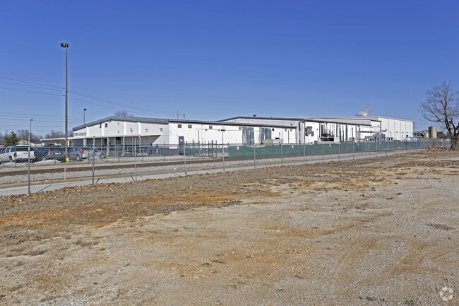
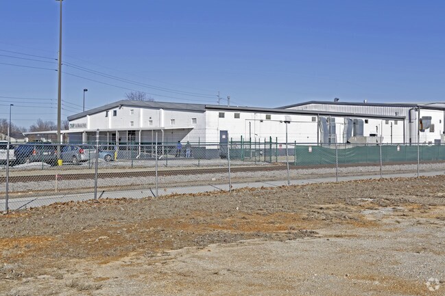
Property Record
750 W Easy St, Rogers, AR 72756

Save to a Folder
{{folder.Name}}
{{folder.ListingIds.length}} Properties
{{folder.ListingIds.length}} Property
Create a New Folder
Property Detail
750 W Easy St
Fayetteville-Springdale-Rogers, AR
ALL NW SE N &E OF RR ROW LESS & EXCEPT BEG NE/C W212 S165 E80 S165 E80 E8 RDS N20 RDS POB
02-00788-000
Benton
Lightindustrial
Arkansas
B and X Area of moderate flood hazard, usually the area between the limits of the 100-year and 500-year floods.
h,g
2025
13.03 AC
2025
East Rogers
020201
Fayetteville/Springdale/Rogers
16,768 SF
NEARBY LISTINGS FOR SALE OR LEASE
DEMOGRAPHICS near 750 W Easy St
1 mile
3 mile
5 mile
2025 Total Population
7,204
49,032
94,552
2030 Population
7,897
53,783
104,463
Pop Growth 2025-2030
+ 9.62%
+ 9.69%
+ 10.48%
Average Age
36
37
37
2025 Total Households
2,625
17,609
35,348
HH Growth 2025-2030
+ 9.98%
+ 10.05%
+ 10.89%
Median Household Inc
$57,138
$70,110
$76,819
Avg Household Size
2.50
2.70
2.60
2025 Avg HH Vehicles
2.00
2.00
2.00
Median Home Value
$254,545
$278,839
$327,143
Median Year Built
1985
1990
1995
Nearby Places
Map Layers
Map Styles
 Street
 Aerial
Layers
 Traffic
 Biking
Places
Listings with unknown addresses are not visible on the map
- Restaurants
- Banks
- Shops
- Fitness
- Groceries
PUBLIC TRANSPORTATION
AIRPORT
Northwest Arkansas Ntl
Drive
Walk
Distance
Northwest Arkansas Ntl
33 min
16.4 mi
Nearby Properties
Address
Land Use
TOTAL SIZE
Lot Size
Zoning
Address
Land Use
TOTAL SIZE
Lot Size
Zoning
117,522 SF
0.12 AC
Address
Land Use
TOTAL SIZE
Lot Size
Zoning
746,783 SF
77.03 AC
Address
Land Use
TOTAL SIZE
Lot Size
Zoning
542,873 SF
16.52 AC
Address
Land Use
TOTAL SIZE
Lot Size
Zoning
97,660 SF
5.35 AC
Address
Land Use
TOTAL SIZE
Lot Size
Zoning
573,476 SF
57.80 AC
Address
Land Use
TOTAL SIZE
Lot Size
Zoning
401,143 SF
31.17 AC
Address
Land Use
TOTAL SIZE
Lot Size
Zoning
249,843 SF
19.21 AC
Address
Land Use
TOTAL SIZE
Lot Size
Zoning
214,791 SF
9.13 AC
Address
Land Use
TOTAL SIZE
Lot Size
Zoning
156,100 SF
7.89 AC
Address
Land Use
TOTAL SIZE
Lot Size
Zoning
274,312 SF
12.24 AC
Address
Land Use
TOTAL SIZE
Lot Size
Zoning
152,759 SF
12.01 AC
Address
Land Use
TOTAL SIZE
Lot Size
Zoning
39,204 SF
4.03 AC
Address
Land Use
TOTAL SIZE
Lot Size
Zoning
114,250 SF
7.54 AC
Address
Land Use
TOTAL SIZE
Lot Size
Zoning
117,522 SF
13.66 AC
Address
Land Use
TOTAL SIZE
Lot Size
Zoning
231,576 SF
15.18 AC
Address
Land Use
TOTAL SIZE
Lot Size
Zoning
102,477 SF
7.15 AC
Address
Land Use
TOTAL SIZE
Lot Size
Zoning
46,851 SF
4.28 AC
Address
Land Use
TOTAL SIZE
Lot Size
Zoning
74,243 SF
14.03 AC
Address
Land Use
TOTAL SIZE
Lot Size
Zoning
205,851 SF
20.13 AC
Address
Land Use
TOTAL SIZE
Lot Size
Zoning
263,095 SF
13.17 AC
Address
Land Use
TOTAL SIZE
Lot Size
Zoning
402,500 SF
19.54 AC
Address
Land Use
TOTAL SIZE
Lot Size
Zoning
191,610 SF
43 AC
Address
Land Use
TOTAL SIZE
Lot Size
Zoning
112,935 SF
6.75 AC
Address
Land Use
TOTAL SIZE
Lot Size
Zoning
195,563 SF
15.49 AC
Address
Land Use
TOTAL SIZE
Lot Size
Zoning
141,332 SF
18.26 AC
Address
Land Use
TOTAL SIZE
Lot Size
Zoning
4,329 SF
2.55 AC
Address
Land Use
TOTAL SIZE
Lot Size
Zoning
109,683 SF
Address
Land Use
TOTAL SIZE
Lot Size
Zoning
101,690 SF
8.76 AC
Address
Land Use
TOTAL SIZE
Lot Size
Zoning
123,791 SF
5.64 AC
Address
Land Use
TOTAL SIZE
Lot Size
Zoning
123,879 SF
5.31 AC
The World's #1 Commercial Real Estate Marketplace
Connect with us
© 2026 CoStar Group
The information above has been obtained from sources believed reliable. While we do not doubt its accuracy we have not verified it and make no guarantee, warranty or representation about it. It is your responsibility to independently confirm its accuracy and completeness. Any projections, opinions, assumptions, or estimates used are for example only and do not represent the current or future performance of the property. The value of this transaction to you depends on tax and other factors which should be evaluated by your tax, financial, and legal advisors. You and your advisors should conduct a careful, independent investigation of the property to determine to your satisfaction the suitability of the property for your needs.