Property Record
7510 Arroyo Cir, Gilroy, CA 95020
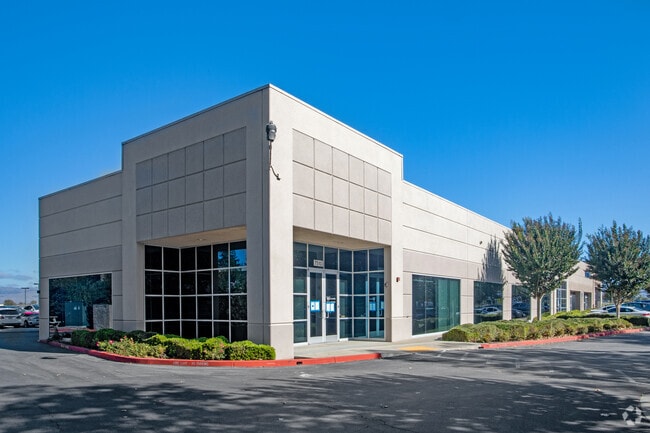

This Property Is For Sale
Property Detail
7510 Arroyo Cir
841-80-004
LOT 2
Scientificpharmaceuticalmedicalresearchfacility
SANTA CLARA
M1
California
AE The base floodplain where base flood elevations are provided. AE Zones are now used on new format FIRMs instead of A1-A30 Zones.
2
2024
0.88 AC
2025
Gilroy
512602
South Bay/San Jose
14,522 SF
San Jose-Sunnyvale-Santa Clara, CA
NEARBY LISTINGS FOR SALE OR LEASE
DEMOGRAPHICS near 7510 Arroyo Cir
1 mile
3 mile
5 mile
2025 Total Population
11,411
57,696
66,887
2030 Population
11,648
58,847
68,117
Pop Growth 2025-2030
+ 2.08%
+ 1.99%
+ 1.84%
Average Age
35
38
39
2025 Total Households
2,950
16,853
19,625
HH Growth 2025-2030
+ 2.00%
+ 2.00%
+ 1.82%
Median Household Inc
$94,689
$122,877
$128,968
Avg Household Size
3.60
3.30
3.30
2025 Avg HH Vehicles
2.00
2.00
2.00
Median Home Value
$767,909
$931,144
$1,002,038
Median Year Built
1978
1986
1987
Nearby Places
Map Layers
Map Styles
 Street
 Aerial
Transit
 Traffic
 Biking
Places
Listings with unknown addresses are not visible on the map
- Restaurants
- Banks
- Shops
- Fitness
- Groceries
PUBLIC TRANSPORTATION
COMMUTER RAIL
Gilroy Caltrain Station Southbound (South Santa Clara County Connector - Caltrain (Caltrain))
Drive
Walk
Distance
Gilroy Caltrain Station Southbound (South Santa Clara County Connector - Caltrain (Caltrain))
3 min
1.3 mi
San Martin Caltrain Station Northbound (South Santa Clara County Connector - Caltrain (Caltrain))
Drive
Walk
Distance
San Martin Caltrain Station Northbound (South Santa Clara County Connector - Caltrain (Caltrain))
11 min
7.0 mi
Freight Ports
Port of Redwood City
Drive
Walk
Distance
Port of Redwood City
66 min
53.3 mi
Nearby Properties
Address
Land Use
TOTAL SIZE
Lot Size
Zoning
Address
Land Use
TOTAL SIZE
Lot Size
Zoning
270,205 SF
6.65 AC
M2
Address
Land Use
TOTAL SIZE
Lot Size
Zoning
921,750 SF
40.33 AC
M2
Address
Land Use
TOTAL SIZE
Lot Size
Zoning
171,339 SF
16.43 AC
C3
Address
Land Use
TOTAL SIZE
Lot Size
Zoning
133,498 SF
12.16 AC
C3
Address
Land Use
TOTAL SIZE
Lot Size
Zoning
156,290 SF
5.87 AC
APD
Address
Land Use
TOTAL SIZE
Lot Size
Zoning
189,303 SF
28.73 AC
CM
Address
Land Use
TOTAL SIZE
Lot Size
Zoning
113,883 SF
9.63 AC
C1
Address
Land Use
TOTAL SIZE
Lot Size
Zoning
103,974 SF
3.90 AC
R4
Address
Land Use
TOTAL SIZE
Lot Size
Zoning
172,348 SF
9.58 AC
A140
Address
Land Use
TOTAL SIZE
Lot Size
Zoning
11.04 AC
M2
Address
Land Use
TOTAL SIZE
Lot Size
Zoning
9.90 AC
M2
Address
Land Use
TOTAL SIZE
Lot Size
Zoning
94,345 SF
10.68 AC
C1
Address
Land Use
TOTAL SIZE
Lot Size
Zoning
219,622 SF
19.80 AC
A1-25
Address
Land Use
TOTAL SIZE
Lot Size
Zoning
102,915 SF
3.81 AC
R3
Address
Land Use
TOTAL SIZE
Lot Size
Zoning
43,973 SF
3.38 AC
R3
Address
Land Use
TOTAL SIZE
Lot Size
Zoning
56.33 AC
M2
Address
Land Use
TOTAL SIZE
Lot Size
Zoning
59.87 AC
M2
Address
Land Use
TOTAL SIZE
Lot Size
Zoning
142,684 SF
4.94 AC
CD
Address
Land Use
TOTAL SIZE
Lot Size
Zoning
123,268 SF
7.62 AC
R3
Address
Land Use
TOTAL SIZE
Lot Size
Zoning
64,893 SF
4.32 AC
R3
Address
Land Use
TOTAL SIZE
Lot Size
Zoning
72,159 SF
4.16 AC
R3
Address
Land Use
TOTAL SIZE
Lot Size
Zoning
148,663 SF
14.79 AC
PUD
Address
Land Use
TOTAL SIZE
Lot Size
Zoning
4,853 SF
11.59 AC
HC
Address
Land Use
TOTAL SIZE
Lot Size
Zoning
32,727 SF
1.82 AC
M2
Address
Land Use
TOTAL SIZE
Lot Size
Zoning
129,000 SF
6.84 AC
MULIT
Address
Land Use
TOTAL SIZE
Lot Size
Zoning
2.94 AC
A140
Address
Land Use
TOTAL SIZE
Lot Size
Zoning
3.43 AC
APD
Address
Land Use
TOTAL SIZE
Lot Size
Zoning
63,560 SF
7.63 AC
A1-25
Address
Land Use
TOTAL SIZE
Lot Size
Zoning
123,709 SF
9.26 AC
M2
The World's #1 Commercial Real Estate Marketplace
Connect with us
© 2026 CoStar Group
The information above has been obtained from sources believed reliable. While we do not doubt its accuracy we have not verified it and make no guarantee, warranty or representation about it. It is your responsibility to independently confirm its accuracy and completeness. Any projections, opinions, assumptions, or estimates used are for example only and do not represent the current or future performance of the property. The value of this transaction to you depends on tax and other factors which should be evaluated by your tax, financial, and legal advisors. You and your advisors should conduct a careful, independent investigation of the property to determine to your satisfaction the suitability of the property for your needs.