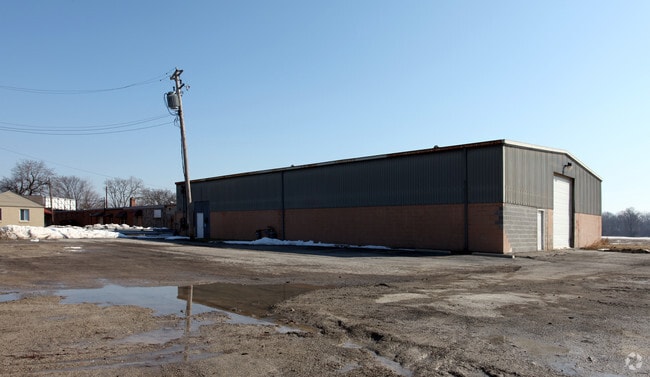
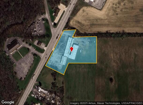
Property Record
7500 N Telegraph Rd, Newport, MI 48166
NEARBY LISTINGS FOR SALE OR LEASE
Property Detail
7500 N Telegraph Rd
Monroe, MI
F-1378 SEC 9 T6S R9E. 4.711 AMOL (SURVEY) COM AT PT ON E ROW LI US 24 & 25, 98.04 FT N 89 DEG 35'00"E FR C SEC 9, TH N 27 DEG
07-009-018-00
Monroe
Dentalbldg
Michigan
2025
4.71 AC
2025
Monroe County
831202
Detroit
37,447 SF
DEMOGRAPHICS near 7500 N Telegraph Rd
1 Mile
3 Mile
5 Mile
2024 Total Population
1,305
12,339
42,677
2029 Population
1,327
12,601
43,397
Pop Growth 2024-2029
+ 1.69%
+ 2.12%
+ 1.69%
Average Age
37
39
41
2024 Total Households
510
4,747
17,257
HH Growth 2024-2029
+ 1.57%
+ 2.11%
+ 1.62%
Median Household Inc
$28,468
$67,934
$64,331
Avg Household Size
2.50
2.50
2.40
2024 Avg HH Vehicles
1.00
2.00
2.00
Median Home Value
$70,981
$184,076
$179,782
Median Year Built
1995
1994
1975
Nearby Places
Map Layers
Map Styles
 Street
 Aerial
- Restaurants
- Banks
- Shops
- Fitness
- Groceries
PUBLIC TRANSPORTATION
AIRPORT
Detroit Metro Wayne County
DRIVE
WALK
Distance
Detroit Metro Wayne County
27 min
19.5 mi
Windsor International
DRIVE
WALK
Distance
Windsor International
61 min
42.0 mi
Nearby Properties
Address
Land Use
TOTAL SIZE
Lot Size
Zoning
Address
Land Use
TOTAL SIZE
Lot Size
Zoning
Address
Land Use
TOTAL SIZE
Lot Size
Zoning
453,206 SF
156.60 AC
AG
Address
Land Use
TOTAL SIZE
Lot Size
Zoning
Address
Land Use
TOTAL SIZE
Lot Size
Zoning
409,765 SF
41.46 AC
Address
Land Use
TOTAL SIZE
Lot Size
Zoning
720,420 SF
71.34 AC
LM-LIGHT M
Address
Land Use
TOTAL SIZE
Lot Size
Zoning
5,216 SF
81.10 AC
MHP
Address
Land Use
TOTAL SIZE
Lot Size
Zoning
291,322 SF
55.05 AC
Address
Land Use
TOTAL SIZE
Lot Size
Zoning
138,119 SF
15.12 AC
Address
Land Use
TOTAL SIZE
Lot Size
Zoning
189,314 SF
28.56 AC
Address
Land Use
TOTAL SIZE
Lot Size
Zoning
290,248 SF
52.03 AC
Address
Land Use
TOTAL SIZE
Lot Size
Zoning
142,400 SF
15.20 AC
Address
Land Use
TOTAL SIZE
Lot Size
Zoning
29.81 AC
MHP
Address
Land Use
TOTAL SIZE
Lot Size
Zoning
43,127 SF
8.10 AC
Address
Land Use
TOTAL SIZE
Lot Size
Zoning
31.45 AC
Address
Land Use
TOTAL SIZE
Lot Size
Zoning
109,626 SF
8.89 AC
Address
Land Use
TOTAL SIZE
Lot Size
Zoning
2,100 SF
36.48 AC
MHP
Address
Land Use
TOTAL SIZE
Lot Size
Zoning
19,364 SF
30.80 AC
Address
Land Use
TOTAL SIZE
Lot Size
Zoning
100,407 SF
16.34 AC
Address
Land Use
TOTAL SIZE
Lot Size
Zoning
40,857 SF
17.30 AC
Address
Land Use
TOTAL SIZE
Lot Size
Zoning
28.87 AC
MHP
Address
Land Use
TOTAL SIZE
Lot Size
Zoning
100,918 SF
14.41 AC
Address
Land Use
TOTAL SIZE
Lot Size
Zoning
3,272 SF
121.75 AC
MHP
Address
Land Use
TOTAL SIZE
Lot Size
Zoning
26.52 AC
MHP
Address
Land Use
TOTAL SIZE
Lot Size
Zoning
74,290 SF
7.10 AC
Address
Land Use
TOTAL SIZE
Lot Size
Zoning
73,476 SF
4.06 AC
Address
Land Use
TOTAL SIZE
Lot Size
Zoning
1,584 SF
23.04 AC
MHP
Address
Land Use
TOTAL SIZE
Lot Size
Zoning
14,560 SF
4.60 AC
Address
Land Use
TOTAL SIZE
Lot Size
Zoning
10,882 SF
5.43 AC
Address
Land Use
TOTAL SIZE
Lot Size
Zoning
6,674 SF
1.17 AC
Address
Land Use
TOTAL SIZE
Lot Size
Zoning
32,640 SF
3 AC
The World's #1 Commercial Real Estate Marketplace
Connect with us
© 2026 CoStar Group
The information above has been obtained from sources believed reliable. While we do not doubt its accuracy we have not verified it and make no guarantee, warranty or representation about it. It is your responsibility to independently confirm its accuracy and completeness. Any projections, opinions, assumptions, or estimates used are for example only and do not represent the current or future performance of the property. The value of this transaction to you depends on tax and other factors which should be evaluated by your tax, financial, and legal advisors. You and your advisors should conduct a careful, independent investigation of the property to determine to your satisfaction the suitability of the property for your needs.