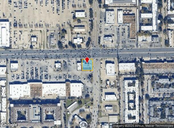
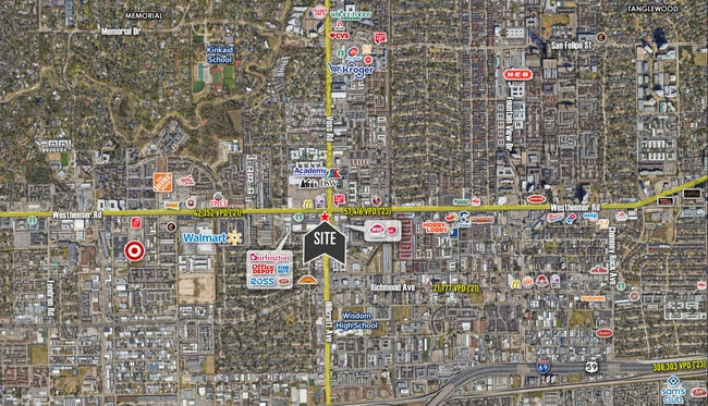
Property Record
7501 Westheimer Rd, Houston, TX 77063

Current Lease Availabilities
NEARBY LISTINGS FOR SALE OR LEASE
Property Detail
7501 Westheimer Rd
0410280040147
Abst 72 J D Taylor
Storebuilding
TR 11G ABST 72 J D TAYLOR
X
Harris
48157C0175L
Texas
2024
0.36 AC
2025
Near West
432102
Houston
6,062 SF
Houston-The Woodlands-Sugar Land, TX
DEMOGRAPHICS near 7501 Westheimer Rd
1 Mile
3 Mile
5 Mile
2024 Total Population
41,467
233,899
546,829
2029 Population
42,785
241,103
563,373
Pop Growth 2024-2029
+ 3.18%
+ 3.08%
+ 3.03%
Average Age
35
37
37
2024 Total Households
19,336
103,796
230,298
HH Growth 2024-2029
+ 3.23%
+ 3.10%
+ 3.10%
Median Household Inc
$44,766
$53,438
$59,802
Avg Household Size
2.10
2.20
2.30
2024 Avg HH Vehicles
1.00
1.00
2.00
Median Home Value
$399,155
$504,129
$530,829
Median Year Built
1976
1980
1981
Nearby Places
Map Layers
Map Styles
 Street
 Aerial
- Restaurants
- Banks
- Shops
- Fitness
- Groceries
PUBLIC TRANSPORTATION
AIRPORT
William P Hobby
DRIVE
WALK
Distance
William P Hobby
34 min
20.7 mi
George Bush Intcntl/Houston
DRIVE
WALK
Distance
George Bush Intcntl/Houston
38 min
28.2 mi
Freight Ports
Port of Houston
DRIVE
WALK
Distance
Port of Houston
31 min
20.0 mi
Nearby Properties
Address
Land Use
TOTAL SIZE
Lot Size
Zoning
Address
Land Use
TOTAL SIZE
Lot Size
Zoning
576,253 SF
5.91 AC
Address
Land Use
TOTAL SIZE
Lot Size
Zoning
2,404,389 SF
16.01 AC
Address
Land Use
TOTAL SIZE
Lot Size
Zoning
716,631 SF
7.04 AC
Address
Land Use
TOTAL SIZE
Lot Size
Zoning
2,626,393 SF
6.70 AC
Address
Land Use
TOTAL SIZE
Lot Size
Zoning
580,059 SF
2.48 AC
Address
Land Use
TOTAL SIZE
Lot Size
Zoning
329,832 SF
1.75 AC
Address
Land Use
TOTAL SIZE
Lot Size
Zoning
832,304 SF
6.24 AC
Address
Land Use
TOTAL SIZE
Lot Size
Zoning
1,062,592 SF
7.41 AC
Address
Land Use
TOTAL SIZE
Lot Size
Zoning
608,704 SF
1.52 AC
Address
Land Use
TOTAL SIZE
Lot Size
Zoning
748,071 SF
4.13 AC
Address
Land Use
TOTAL SIZE
Lot Size
Zoning
771,702 SF
2.51 AC
Address
Land Use
TOTAL SIZE
Lot Size
Zoning
576,200 SF
2.65 AC
Address
Land Use
TOTAL SIZE
Lot Size
Zoning
527,312 SF
2.58 AC
Address
Land Use
TOTAL SIZE
Lot Size
Zoning
612,663 SF
7 AC
Address
Land Use
TOTAL SIZE
Lot Size
Zoning
549,506 SF
2.05 AC
Address
Land Use
TOTAL SIZE
Lot Size
Zoning
392,218 SF
1.21 AC
Address
Land Use
TOTAL SIZE
Lot Size
Zoning
305,760 SF
2.22 AC
Address
Land Use
TOTAL SIZE
Lot Size
Zoning
1,012,117 SF
3.29 AC
Address
Land Use
TOTAL SIZE
Lot Size
Zoning
1,819,963 SF
5.30 AC
Address
Land Use
TOTAL SIZE
Lot Size
Zoning
214,297 SF
15.23 AC
Address
Land Use
TOTAL SIZE
Lot Size
Zoning
415,160 SF
4.47 AC
Address
Land Use
TOTAL SIZE
Lot Size
Zoning
128,404 SF
2.88 AC
Address
Land Use
TOTAL SIZE
Lot Size
Zoning
323,456 SF
3.91 AC
Address
Land Use
TOTAL SIZE
Lot Size
Zoning
133,258 SF
11.56 AC
Address
Land Use
TOTAL SIZE
Lot Size
Zoning
702,286 SF
15.67 AC
Address
Land Use
TOTAL SIZE
Lot Size
Zoning
561,732 SF
6.10 AC
Address
Land Use
TOTAL SIZE
Lot Size
Zoning
281,973 SF
11.56 AC
Address
Land Use
TOTAL SIZE
Lot Size
Zoning
126,877 SF
34.71 AC
Address
Land Use
TOTAL SIZE
Lot Size
Zoning
521,287 SF
3.90 AC
Address
Land Use
TOTAL SIZE
Lot Size
Zoning
385,587 SF
3.08 AC
The World's #1 Commercial Real Estate Marketplace
Connect with us
© 2025 CoStar Group
The information above has been obtained from sources believed reliable. While we do not doubt its accuracy we have not verified it and make no guarantee, warranty or representation about it. It is your responsibility to independently confirm its accuracy and completeness. Any projections, opinions, assumptions, or estimates used are for example only and do not represent the current or future performance of the property. The value of this transaction to you depends on tax and other factors which should be evaluated by your tax, financial, and legal advisors. You and your advisors should conduct a careful, independent investigation of the property to determine to your satisfaction the suitability of the property for your needs.