No Photo
Property Record
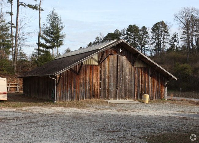
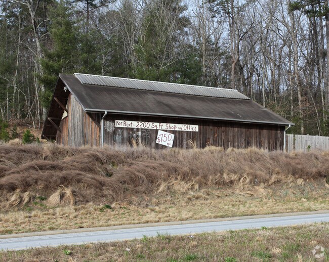
7506 Highway 441 S, Lakemont, GA 30552

NEARBY LISTINGS FOR SALE OR LEASE
-
-
View all Lakemont listings for sale on LoopNet.com
Property Detail
7506 Highway 441 S
046B-031
1.0 ACRES LL 7 LD 5
Commercialnec
Rabun
X
Georgia
13241C0270D
0.99 AC
2025
Georgia Northeast
2025
Other Market Areas
970302
DEMOGRAPHICS near 7506 Highway 441 S
1 Mile
3 Mile
5 Mile
2024 Total Population
617
1,920
3,762
2029 Population
635
1,987
3,890
Pop Growth 2024-2029
+ 2.92%
+ 3.49%
+ 3.40%
Average Age
44
45
45
2024 Total Households
250
816
1,565
HH Growth 2024-2029
+ 2.40%
+ 3.31%
+ 3.07%
Median Household Inc
$51,333
$48,778
$49,192
Avg Household Size
2.40
2.30
2.30
2024 Avg HH Vehicles
2.00
2.00
2.00
Median Home Value
$213,265
$249,655
$252,254
Median Year Built
1986
1988
1987
Nearby Places
Map Layers
Map Styles
 Street
 Aerial
- Restaurants
- Banks
- Shops
- Fitness
- Groceries
Nearby Properties
Address
Land Use
TOTAL SIZE
Lot Size
Zoning
Address
Land Use
TOTAL SIZE
Lot Size
Zoning
160,000 SF
50 AC
A
Address
Land Use
TOTAL SIZE
Lot Size
Zoning
5,000 SF
76.32 AC
A
Address
Land Use
TOTAL SIZE
Lot Size
Zoning
113,232 SF
45.07 AC
A
Address
Land Use
TOTAL SIZE
Lot Size
Zoning
19,800 SF
5.53 AC
HB
Address
Land Use
TOTAL SIZE
Lot Size
Zoning
40.35 AC
HB
Address
Land Use
TOTAL SIZE
Lot Size
Zoning
10,132 SF
9 AC
Address
Land Use
TOTAL SIZE
Lot Size
Zoning
5,504 SF
8.40 AC
A
Address
Land Use
TOTAL SIZE
Lot Size
Zoning
98.13 AC
A
Address
Land Use
TOTAL SIZE
Lot Size
Zoning
91.52 AC
A
Address
Land Use
TOTAL SIZE
Lot Size
Zoning
4,536 SF
5 AC
A
Address
Land Use
TOTAL SIZE
Lot Size
Zoning
0.81 AC
VC
Address
Land Use
TOTAL SIZE
Lot Size
Zoning
6,600 SF
0.37 AC
VC
Address
Land Use
TOTAL SIZE
Lot Size
Zoning
0.44 AC
VC
Address
Land Use
TOTAL SIZE
Lot Size
Zoning
1,344 SF
5.15 AC
CB
Address
Land Use
TOTAL SIZE
Lot Size
Zoning
15,744 SF
2.28 AC
CB
Address
Land Use
TOTAL SIZE
Lot Size
Zoning
89.46 AC
A
Address
Land Use
TOTAL SIZE
Lot Size
Zoning
1,788 SF
14.74 AC
A
Address
Land Use
TOTAL SIZE
Lot Size
Zoning
145.46 AC
R1
Address
Land Use
TOTAL SIZE
Lot Size
Zoning
10,950 SF
1.60 AC
M1
Address
Land Use
TOTAL SIZE
Lot Size
Zoning
1,400 SF
VC
Address
Land Use
TOTAL SIZE
Lot Size
Zoning
2,304 SF
1 AC
HB
Address
Land Use
TOTAL SIZE
Lot Size
Zoning
42.67 AC
A
Address
Land Use
TOTAL SIZE
Lot Size
Zoning
11.81 AC
CB
Address
Land Use
TOTAL SIZE
Lot Size
Zoning
56.10 AC
A
Address
Land Use
TOTAL SIZE
Lot Size
Zoning
8.95 AC
A
Address
Land Use
TOTAL SIZE
Lot Size
Zoning
27.49 AC
A
Address
Land Use
TOTAL SIZE
Lot Size
Zoning
1,058 SF
55.97 AC
A
Address
Land Use
TOTAL SIZE
Lot Size
Zoning
28.75 AC
A
Address
Land Use
TOTAL SIZE
Lot Size
Zoning
1,128 SF
5.25 AC
A
The World's #1 Commercial Real Estate Marketplace
Connect with us
© 2025 CoStar Group
The information above has been obtained from sources believed reliable. While we do not doubt its accuracy we have not verified it and make no guarantee, warranty or representation about it. It is your responsibility to independently confirm its accuracy and completeness. Any projections, opinions, assumptions, or estimates used are for example only and do not represent the current or future performance of the property. The value of this transaction to you depends on tax and other factors which should be evaluated by your tax, financial, and legal advisors. You and your advisors should conduct a careful, independent investigation of the property to determine to your satisfaction the suitability of the property for your needs.