Property Record
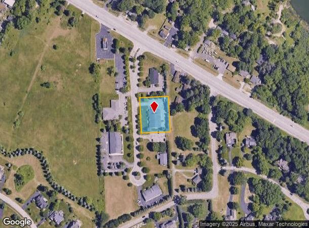
7508 M E Cad Blvd, Clarkston, MI 48348
NEARBY LISTINGS FOR SALE OR LEASE
Property Detail
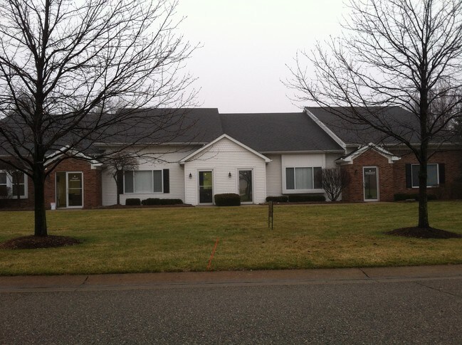
7508 M E Cad Blvd
07-14-478-031
Oakland County Condominium
Officebuilding
T4N, R8E, SEC 14 OAKLAND COUNTY CONDOMINIUM PLAN NO 932 DESIGN-TECH OFFICE PARK UNIT 6 L 15688 P 035 9-27-95 FR 002 & 014
X
Oakland
26125C0330F
Michigan
2024
0.76 AC
2024
St Clair & Lapeer Counties
126300
Detroit
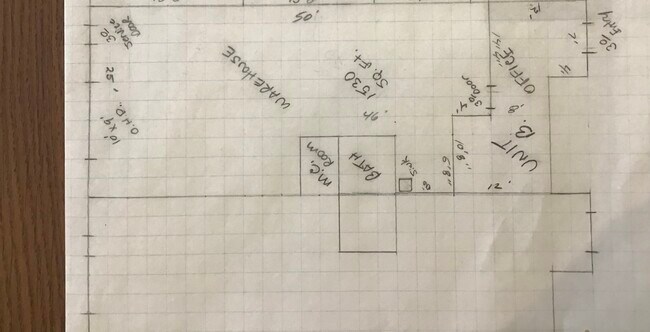
6,695 SF
Detroit-Warren-Dearborn, MI
DEMOGRAPHICS near 7508 M E Cad Blvd
1 Mile
3 Mile
5 Mile
2024 Total Population
2,562
16,316
41,594
2029 Population
2,529
16,193
41,268
Pop Growth 2024-2029
(1.29%)
(0.75%)
(0.78%)
Average Age
42
43
43
2024 Total Households
984
5,953
16,006
HH Growth 2024-2029
(1.32%)
(0.81%)
(0.86%)
Median Household Inc
$96,057
$116,629
$101,732
Avg Household Size
2.60
2.70
2.60
2024 Avg HH Vehicles
2.00
2.00
2.00
Median Home Value
$431,690
$376,895
$327,365
Median Year Built
1992
1985
1982
Nearby Places
Map Layers
Map Styles
 Street
 Aerial
- Restaurants
- Banks
- Shops
- Fitness
- Groceries
PUBLIC TRANSPORTATION
AIRPORT
Bishop International
DRIVE
WALK
Distance
Bishop International
39 min
24.6 mi
Freight Ports
Port of Toledo
DRIVE
WALK
Distance
Port of Toledo
113 min
87.8 mi
SALE & LEASE HISTORY
LISTING DATE
SALE/LEASE

Mar 30, 2022
For Lease
Nearby Properties
Address
Land Use
TOTAL SIZE
Lot Size
Zoning
Address
Land Use
TOTAL SIZE
Lot Size
Zoning
21,719 SF
26.34 AC
R2
Address
Land Use
TOTAL SIZE
Lot Size
Zoning
68,725 SF
4.96 AC
PUD
Address
Land Use
TOTAL SIZE
Lot Size
Zoning
44.10 AC
PUD
Address
Land Use
TOTAL SIZE
Lot Size
Zoning
151,736 SF
26.03 AC
C-2
Address
Land Use
TOTAL SIZE
Lot Size
Zoning
48,645 SF
6.68 AC
PUD
Address
Land Use
TOTAL SIZE
Lot Size
Zoning
32,059 SF
BLL
Address
Land Use
TOTAL SIZE
Lot Size
Zoning
739 SF
5.36 AC
R1A
Address
Land Use
TOTAL SIZE
Lot Size
Zoning
34,111 SF
20.14 AC
Address
Land Use
TOTAL SIZE
Lot Size
Zoning
34,807 SF
3.34 AC
OS-2
Address
Land Use
TOTAL SIZE
Lot Size
Zoning
30,726 SF
3.44 AC
R3
Address
Land Use
TOTAL SIZE
Lot Size
Zoning
30,711 SF
3.17 AC
PUD
Address
Land Use
TOTAL SIZE
Lot Size
Zoning
80,974 SF
8.37 AC
C-3
Address
Land Use
TOTAL SIZE
Lot Size
Zoning
261,633 SF
1,321.20 AC
C2GEN
Address
Land Use
TOTAL SIZE
Lot Size
Zoning
26,221 SF
15.76 AC
C2
Address
Land Use
TOTAL SIZE
Lot Size
Zoning
31,057 SF
5.40 AC
BI
Address
Land Use
TOTAL SIZE
Lot Size
Zoning
44,258 SF
8.86 AC
C2GEN
Address
Land Use
TOTAL SIZE
Lot Size
Zoning
40,909 SF
3.73 AC
AI
Address
Land Use
TOTAL SIZE
Lot Size
Zoning
28.31 AC
R1C
Address
Land Use
TOTAL SIZE
Lot Size
Zoning
59,491 SF
6.94 AC
C2GEN
Address
Land Use
TOTAL SIZE
Lot Size
Zoning
34.16 AC
PUD
Address
Land Use
TOTAL SIZE
Lot Size
Zoning
74,592 SF
8.05 AC
RMMULT
Address
Land Use
TOTAL SIZE
Lot Size
Zoning
13,880 SF
2.72 AC
C-3
Address
Land Use
TOTAL SIZE
Lot Size
Zoning
57,600 SF
15.72 AC
M1LITE
Address
Land Use
TOTAL SIZE
Lot Size
Zoning
28,694 SF
5.03 AC
C2GEN
Address
Land Use
TOTAL SIZE
Lot Size
Zoning
77,403 SF
4.58 AC
M1LITE
Address
Land Use
TOTAL SIZE
Lot Size
Zoning
14,218 SF
16.94 AC
Address
Land Use
TOTAL SIZE
Lot Size
Zoning
69,704 SF
110.79 AC
M1
Address
Land Use
TOTAL SIZE
Lot Size
Zoning
23,178 SF
2.13 AC
C-2
Address
Land Use
TOTAL SIZE
Lot Size
Zoning
23.56 AC
OS-2
Address
Land Use
TOTAL SIZE
Lot Size
Zoning
10,934 SF
2.41 AC
The World's #1 Commercial Real Estate Marketplace
Connect with us
© 2025 CoStar Group
The information above has been obtained from sources believed reliable. While we do not doubt its accuracy we have not verified it and make no guarantee, warranty or representation about it. It is your responsibility to independently confirm its accuracy and completeness. Any projections, opinions, assumptions, or estimates used are for example only and do not represent the current or future performance of the property. The value of this transaction to you depends on tax and other factors which should be evaluated by your tax, financial, and legal advisors. You and your advisors should conduct a careful, independent investigation of the property to determine to your satisfaction the suitability of the property for your needs.