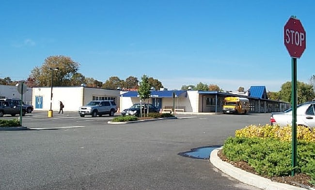
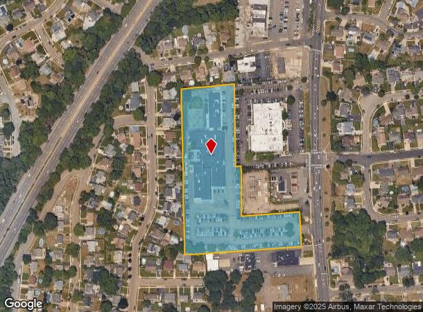
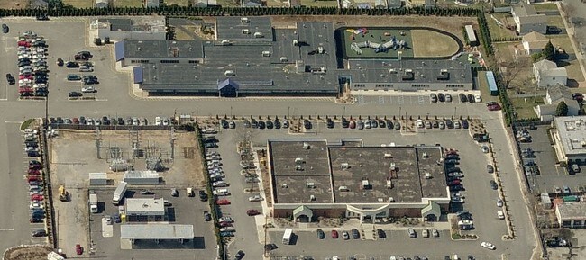
Property Record
750A Hicksville Rd, Massapequa, NY 11758
NEARBY LISTINGS FOR SALE OR LEASE
-
-
View all Massapequa listings for sale on LoopNet.com
Property Detail
750A Hicksville Rd
2489-52-A-00-0312-0
TOWN #3 SCH DIST 018
Daycare
Nassau
X
New York
36103C0830H
312
0
4.66 AC
2025
Eastern Nassau
520900
Long Island (New York)
85,798 SF
Nassau County-Suffolk County, NY
DEMOGRAPHICS near 750A Hicksville Rd
1 Mile
3 Mile
5 Mile
2024 Total Population
22,404
179,847
417,239
2029 Population
21,937
176,267
409,280
Pop Growth 2024-2029
(2.08%)
(1.99%)
(1.91%)
Average Age
42
42
42
2024 Total Households
7,315
59,610
137,110
HH Growth 2024-2029
(2.23%)
(2.13%)
(2.04%)
Median Household Inc
$140,015
$135,081
$132,202
Avg Household Size
3.00
2.90
2.90
2024 Avg HH Vehicles
2.00
2.00
2.00
Median Home Value
$613,573
$599,117
$619,315
Median Year Built
1954
1954
1955
Nearby Places
- Restaurants
- Banks
- Shops
- Fitness
- Groceries
PUBLIC TRANSPORTATION
COMMUTER RAIL
Massapequa Station (Babylon Branch - Long Island Rail Road)
DRIVE
WALK
Distance
Massapequa Station (Babylon Branch - Long Island Rail Road)
5 min
2.7 mi
Seaford Station (Babylon Branch - Long Island Rail Road)
DRIVE
WALK
Distance
Seaford Station (Babylon Branch - Long Island Rail Road)
5 min
2.9 mi
AIRPORT
John F Kennedy International
DRIVE
WALK
Distance
John F Kennedy International
30 min
20.6 mi
Long Island MacArthur
DRIVE
WALK
Distance
Long Island MacArthur
35 min
25.3 mi
LaGuardia
DRIVE
WALK
Distance
LaGuardia
40 min
27.6 mi
Freight Ports
NY - Red Hook Container Terminal
DRIVE
WALK
Distance
NY - Red Hook Container Terminal
51 min
32.0 mi
Nearby Properties
Address
Land Use
TOTAL SIZE
Lot Size
Zoning
Address
Land Use
TOTAL SIZE
Lot Size
Zoning
49,840 SF
729.60 AC
Address
Land Use
TOTAL SIZE
Lot Size
Zoning
163.85 AC
Address
Land Use
TOTAL SIZE
Lot Size
Zoning
892,140 SF
31.82 AC
Address
Land Use
TOTAL SIZE
Lot Size
Zoning
105,868 SF
198 AC
Address
Land Use
TOTAL SIZE
Lot Size
Zoning
116,514 SF
382 AC
Address
Land Use
TOTAL SIZE
Lot Size
Zoning
4,356 SF
246.70 AC
Address
Land Use
TOTAL SIZE
Lot Size
Zoning
77,270 SF
21.67 AC
Address
Land Use
TOTAL SIZE
Lot Size
Zoning
Address
Land Use
TOTAL SIZE
Lot Size
Zoning
249,762 SF
18.36 AC
Address
Land Use
TOTAL SIZE
Lot Size
Zoning
288 SF
194.85 AC
Address
Land Use
TOTAL SIZE
Lot Size
Zoning
Address
Land Use
TOTAL SIZE
Lot Size
Zoning
384,267 SF
29.25 AC
Address
Land Use
TOTAL SIZE
Lot Size
Zoning
10,072 SF
22.75 AC
Address
Land Use
TOTAL SIZE
Lot Size
Zoning
1,500 SF
125.69 AC
Address
Land Use
TOTAL SIZE
Lot Size
Zoning
348,954 SF
9.98 AC
Address
Land Use
TOTAL SIZE
Lot Size
Zoning
8,000 SF
17.75 AC
Address
Land Use
TOTAL SIZE
Lot Size
Zoning
120,000 SF
28.96 AC
Address
Land Use
TOTAL SIZE
Lot Size
Zoning
68,555 SF
20.14 AC
Address
Land Use
TOTAL SIZE
Lot Size
Zoning
144,358 SF
21.73 AC
Address
Land Use
TOTAL SIZE
Lot Size
Zoning
76,790 SF
19.32 AC
Address
Land Use
TOTAL SIZE
Lot Size
Zoning
136,804 SF
10.56 AC
Address
Land Use
TOTAL SIZE
Lot Size
Zoning
112,053 SF
16.13 AC
Address
Land Use
TOTAL SIZE
Lot Size
Zoning
28,392 SF
16.58 AC
Address
Land Use
TOTAL SIZE
Lot Size
Zoning
992,672 SF
37.18 AC
Address
Land Use
TOTAL SIZE
Lot Size
Zoning
13,200 SF
9.44 AC
Address
Land Use
TOTAL SIZE
Lot Size
Zoning
28.33 AC
Address
Land Use
TOTAL SIZE
Lot Size
Zoning
27.91 AC
Address
Land Use
TOTAL SIZE
Lot Size
Zoning
79,735 SF
14.33 AC
Address
Land Use
TOTAL SIZE
Lot Size
Zoning
55,620 SF
19.30 AC
Address
Land Use
TOTAL SIZE
Lot Size
Zoning
60,000 SF
262.23 AC
The World's #1 Commercial Real Estate Marketplace
Connect with us
© 2025 CoStar Group
The information above has been obtained from sources believed reliable. While we do not doubt its accuracy we have not verified it and make no guarantee, warranty or representation about it. It is your responsibility to independently confirm its accuracy and completeness. Any projections, opinions, assumptions, or estimates used are for example only and do not represent the current or future performance of the property. The value of this transaction to you depends on tax and other factors which should be evaluated by your tax, financial, and legal advisors. You and your advisors should conduct a careful, independent investigation of the property to determine to your satisfaction the suitability of the property for your needs.