Property Record
751 Ash St Ne, Lonsdale, MN 55046
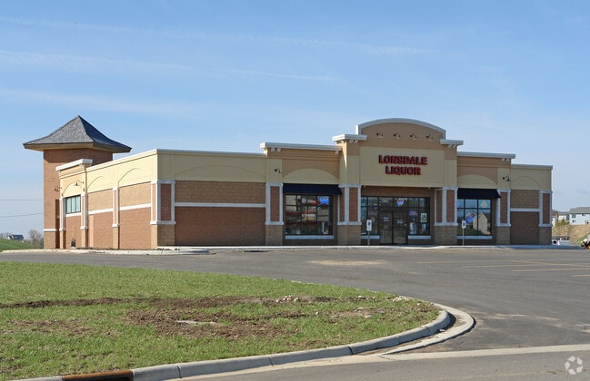

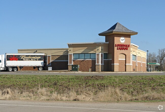
Property Detail
751 Ash St Ne
Faribault-Northfield, MN
LOT 5 BLOCK 1 OF ROLLING RIDGE MKT PL 3RD ADD
19.25.2.56.005
Rice
Storebuilding
Minnesota
B and X Area of moderate flood hazard, usually the area between the limits of the 100-year and 500-year floods.
5
0
0.25 AC
2025
Minnesota South Area
070102
Other Market Areas
7,545 SF
NEARBY LISTINGS FOR SALE OR LEASE
-
-
View all Lonsdale listings for sale on LoopNet.com
DEMOGRAPHICS near 751 Ash St Ne
1 mile
3 mile
5 mile
2025 Total Population
4,280
5,824
7,682
2030 Population
4,452
6,038
7,943
Pop Growth 2025-2030
+ 4.02%
+ 3.67%
+ 3.40%
Average Age
34
36
37
2025 Total Households
1,434
1,984
2,662
HH Growth 2025-2030
+ 4.32%
+ 3.98%
+ 3.68%
Median Household Inc
$89,868
$89,468
$92,562
Avg Household Size
2.90
2.90
2.80
2025 Avg HH Vehicles
2.00
2.00
3.00
Median Home Value
$336,400
$337,820
$354,166
Median Year Built
2003
2001
1998
Nearby Places
Map Layers
Map Styles
 Street
 Aerial
Layers
 Traffic
 Biking
Places
Listings with unknown addresses are not visible on the map
- Restaurants
- Banks
- Shops
- Fitness
- Groceries
PUBLIC TRANSPORTATION
AIRPORT
Minneapolis-St Paul International/Wold-Chamberlain
Drive
Walk
Distance
Minneapolis-St Paul International/Wold-Chamberlain
49 min
39.1 mi
Nearby Properties
Address
Land Use
TOTAL SIZE
Lot Size
Zoning
Address
Land Use
TOTAL SIZE
Lot Size
Zoning
3,783 SF
20 AC
Address
Land Use
TOTAL SIZE
Lot Size
Zoning
18,543 SF
5.14 AC
Address
Land Use
TOTAL SIZE
Lot Size
Zoning
7,795 SF
2.10 AC
Address
Land Use
TOTAL SIZE
Lot Size
Zoning
26,924 SF
7.25 AC
Address
Land Use
TOTAL SIZE
Lot Size
Zoning
12,187 SF
8.30 AC
Address
Land Use
TOTAL SIZE
Lot Size
Zoning
2,450 SF
13.10 AC
Address
Land Use
TOTAL SIZE
Lot Size
Zoning
177.40 AC
Address
Land Use
TOTAL SIZE
Lot Size
Zoning
6,222 SF
7.89 AC
Address
Land Use
TOTAL SIZE
Lot Size
Zoning
14,516 SF
2.56 AC
Address
Land Use
TOTAL SIZE
Lot Size
Zoning
4,889 SF
3.60 AC
Address
Land Use
TOTAL SIZE
Lot Size
Zoning
5,732 SF
1.71 AC
Address
Land Use
TOTAL SIZE
Lot Size
Zoning
12,400 SF
3 AC
Address
Land Use
TOTAL SIZE
Lot Size
Zoning
2,688 SF
117 AC
Address
Land Use
TOTAL SIZE
Lot Size
Zoning
20,963 SF
0.80 AC
Address
Land Use
TOTAL SIZE
Lot Size
Zoning
8,826 SF
1.51 AC
Address
Land Use
TOTAL SIZE
Lot Size
Zoning
15,120 SF
7.24 AC
Address
Land Use
TOTAL SIZE
Lot Size
Zoning
5,280 SF
110 AC
Address
Land Use
TOTAL SIZE
Lot Size
Zoning
6,720 SF
3.91 AC
Address
Land Use
TOTAL SIZE
Lot Size
Zoning
5,357 SF
1.34 AC
Address
Land Use
TOTAL SIZE
Lot Size
Zoning
9,100 SF
1.29 AC
Address
Land Use
TOTAL SIZE
Lot Size
Zoning
6,400 SF
3.25 AC
Address
Land Use
TOTAL SIZE
Lot Size
Zoning
111.41 AC
Address
Land Use
TOTAL SIZE
Lot Size
Zoning
15,120 SF
2.87 AC
Address
Land Use
TOTAL SIZE
Lot Size
Zoning
2,608 SF
0.69 AC
Address
Land Use
TOTAL SIZE
Lot Size
Zoning
6,448 SF
1 AC
Address
Land Use
TOTAL SIZE
Lot Size
Zoning
7,000 SF
1.50 AC
Address
Land Use
TOTAL SIZE
Lot Size
Zoning
6,112 SF
0.55 AC
Address
Land Use
TOTAL SIZE
Lot Size
Zoning
8,000 SF
2.55 AC
Address
Land Use
TOTAL SIZE
Lot Size
Zoning
The World's #1 Commercial Real Estate Marketplace
Connect with us
© 2026 CoStar Group
The information above has been obtained from sources believed reliable. While we do not doubt its accuracy we have not verified it and make no guarantee, warranty or representation about it. It is your responsibility to independently confirm its accuracy and completeness. Any projections, opinions, assumptions, or estimates used are for example only and do not represent the current or future performance of the property. The value of this transaction to you depends on tax and other factors which should be evaluated by your tax, financial, and legal advisors. You and your advisors should conduct a careful, independent investigation of the property to determine to your satisfaction the suitability of the property for your needs.