Property Record
751 Oakland Rd, Spindale, NC 28160


NEARBY LISTINGS FOR SALE OR LEASE
-
-
View all Spindale listings for sale on LoopNet.com
Property Detail
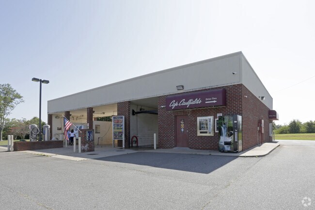
751 Oakland Rd
417220
The James Mcdonald Property
Realpropertynec
GPIN:1529209033420000; APTS OAKLAND RD
X
Rutherford
3710152900J
North Carolina
2025
1.14 AC
2025
North Carolina West/Cherokee Area
960900
Other Market Areas
576 SF
Forest City, NC
DEMOGRAPHICS near 751 Oakland Rd
1 Mile
3 Mile
5 Mile
2024 Total Population
1,630
14,095
28,067
2029 Population
1,655
14,364
28,562
Pop Growth 2024-2029
+ 1.53%
+ 1.91%
+ 1.76%
Average Age
42
42
42
2024 Total Households
701
5,865
11,484
HH Growth 2024-2029
+ 1.28%
+ 1.79%
+ 1.64%
Median Household Inc
$35,221
$34,781
$39,019
Avg Household Size
2.30
2.30
2.30
2024 Avg HH Vehicles
2.00
2.00
2.00
Median Home Value
$127,053
$125,629
$151,833
Median Year Built
1974
1971
1973
Nearby Places
Map Layers
Map Styles
 Street
 Aerial
- Restaurants
- Banks
- Shops
- Fitness
- Groceries
PUBLIC TRANSPORTATION
AIRPORT
Greenville Spartanburg International
DRIVE
WALK
Distance
Greenville Spartanburg International
67 min
49.0 mi
SALE & LEASE HISTORY
LISTING DATE
SALE/LEASE

Jun 17, 2025
For Sale
Jul 11, 2017
For Sale
Nearby Properties
Address
Land Use
TOTAL SIZE
Lot Size
Zoning
Address
Land Use
TOTAL SIZE
Lot Size
Zoning
204,184 SF
28.30 AC
C3
Address
Land Use
TOTAL SIZE
Lot Size
Zoning
87,123 SF
1.98 AC
Address
Land Use
TOTAL SIZE
Lot Size
Zoning
87,108 SF
26.73 AC
GC
Address
Land Use
TOTAL SIZE
Lot Size
Zoning
37,979 SF
9.36 AC
R8
Address
Land Use
TOTAL SIZE
Lot Size
Zoning
61,023 SF
7.64 AC
R6
Address
Land Use
TOTAL SIZE
Lot Size
Zoning
23,826 SF
13.78 AC
M1
Address
Land Use
TOTAL SIZE
Lot Size
Zoning
111,158 SF
11.15 AC
C3
Address
Land Use
TOTAL SIZE
Lot Size
Zoning
1,408 SF
6.95 AC
R20
Address
Land Use
TOTAL SIZE
Lot Size
Zoning
63,006 SF
14.29 AC
Address
Land Use
TOTAL SIZE
Lot Size
Zoning
328,907 SF
52.37 AC
Address
Land Use
TOTAL SIZE
Lot Size
Zoning
58,300 SF
3.13 AC
C3
Address
Land Use
TOTAL SIZE
Lot Size
Zoning
4,982 SF
27.13 AC
Address
Land Use
TOTAL SIZE
Lot Size
Zoning
2,026 SF
8.71 AC
R6
Address
Land Use
TOTAL SIZE
Lot Size
Zoning
87,740 SF
10.47 AC
C3
Address
Land Use
TOTAL SIZE
Lot Size
Zoning
8,880 SF
11.85 AC
C3
Address
Land Use
TOTAL SIZE
Lot Size
Zoning
12,480 SF
43 AC
Address
Land Use
TOTAL SIZE
Lot Size
Zoning
95,267 SF
8.40 AC
GC
Address
Land Use
TOTAL SIZE
Lot Size
Zoning
16,074 SF
101.60 AC
Address
Land Use
TOTAL SIZE
Lot Size
Zoning
12,580 SF
7.90 AC
R8
Address
Land Use
TOTAL SIZE
Lot Size
Zoning
53,790 SF
6.37 AC
R6
Address
Land Use
TOTAL SIZE
Lot Size
Zoning
483 SF
6.26 AC
C3
Address
Land Use
TOTAL SIZE
Lot Size
Zoning
36,693 SF
3.04 AC
C3
Address
Land Use
TOTAL SIZE
Lot Size
Zoning
4,700 SF
4.70 AC
C2
Address
Land Use
TOTAL SIZE
Lot Size
Zoning
23,990 SF
3 AC
Address
Land Use
TOTAL SIZE
Lot Size
Zoning
6,448 SF
3.30 AC
GC
Address
Land Use
TOTAL SIZE
Lot Size
Zoning
6,000 SF
15.30 AC
Address
Land Use
TOTAL SIZE
Lot Size
Zoning
1,444 SF
5.06 AC
C3
Address
Land Use
TOTAL SIZE
Lot Size
Zoning
6,988 SF
1.51 AC
R6
Address
Land Use
TOTAL SIZE
Lot Size
Zoning
150,739 SF
35.14 AC
Address
Land Use
TOTAL SIZE
Lot Size
Zoning
17,755 SF
7.05 AC
R8
The World's #1 Commercial Real Estate Marketplace
Connect with us
© 2026 CoStar Group
The information above has been obtained from sources believed reliable. While we do not doubt its accuracy we have not verified it and make no guarantee, warranty or representation about it. It is your responsibility to independently confirm its accuracy and completeness. Any projections, opinions, assumptions, or estimates used are for example only and do not represent the current or future performance of the property. The value of this transaction to you depends on tax and other factors which should be evaluated by your tax, financial, and legal advisors. You and your advisors should conduct a careful, independent investigation of the property to determine to your satisfaction the suitability of the property for your needs.