Property Record
7510 Wi Se Altman Rd, Gresham, OR 97080
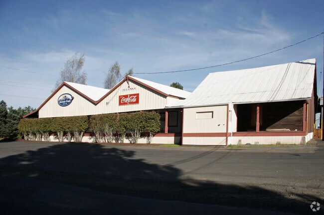

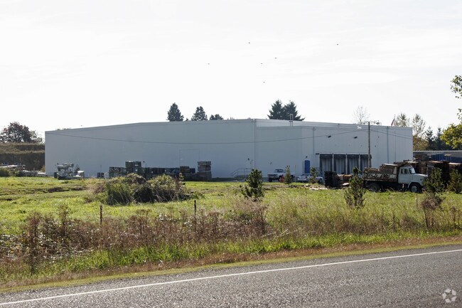
Property Detail
7510 Wi Se Altman Rd
R342503
SECTION 21 1S 4E, TL 200 13.45 ACRES, LAND & IMPS SEE R646261 (R994210521) & R657125 (R994210522) & R688729 (R994210525) & R690402 (R994210526) FOR MACH & EQUIP
Industrialgeneral
MULTNOMAH
MUA20
Oregon
B and X Area of moderate flood hazard, usually the area between the limits of the 100-year and 500-year floods.
6.60 AC
2025
NE Outlying
2025
Portland
009907
Portland-Vancouver-Hillsboro, OR-WA
25,000 SF
NEARBY LISTINGS FOR SALE OR LEASE
-
-
View all Gresham listings for sale on LoopNet.com
DEMOGRAPHICS near 7510 Wi Se Altman Rd
1 mile
3 mile
5 mile
2025 Total Population
831
10,733
52,774
2030 Population
794
10,627
51,913
Pop Growth 2025-2030
(4.45%)
(0.99%)
(1.63%)
Average Age
45
43
41
2025 Total Households
293
3,582
18,418
HH Growth 2025-2030
(5.12%)
(1.28%)
(1.96%)
Median Household Inc
$121,474
$111,868
$91,735
Avg Household Size
2.80
2.90
2.80
2025 Avg HH Vehicles
3.00
3.00
2.00
Median Home Value
$697,916
$646,529
$515,994
Median Year Built
1975
1983
1982
Nearby Places
Map Layers
Map Styles
 Street
 Aerial
Transit
 Traffic
 Biking
Places
Listings with unknown addresses are not visible on the map
- Restaurants
- Banks
- Shops
- Fitness
- Groceries
PUBLIC TRANSPORTATION
AIRPORT
Portland International
Drive
Walk
Distance
Portland International
35 min
20.6 mi
Freight Ports
Port of Portland
Drive
Walk
Distance
Port of Portland
41 min
26.0 mi
Nearby Properties
Address
Land Use
TOTAL SIZE
Lot Size
Zoning
Address
Land Use
TOTAL SIZE
Lot Size
Zoning
300,843 SF
37.27 AC
MUA20
Address
Land Use
TOTAL SIZE
Lot Size
Zoning
102,431 SF
11.56 AC
RC
Address
Land Use
TOTAL SIZE
Lot Size
Zoning
60,280 SF
10.62 AC
LDR
Address
Land Use
TOTAL SIZE
Lot Size
Zoning
45,616 SF
68.59 AC
CFU
Address
Land Use
TOTAL SIZE
Lot Size
Zoning
40,416 SF
32.10 AC
CFU4
Address
Land Use
TOTAL SIZE
Lot Size
Zoning
5,376 SF
9.60 AC
RRFF5
Address
Land Use
TOTAL SIZE
Lot Size
Zoning
13,700 SF
4.80 AC
LDR7
Address
Land Use
TOTAL SIZE
Lot Size
Zoning
19,572 SF
1.86 AC
TR
Address
Land Use
TOTAL SIZE
Lot Size
Zoning
Address
Land Use
TOTAL SIZE
Lot Size
Zoning
9,345 SF
4.94 AC
MUA20
Address
Land Use
TOTAL SIZE
Lot Size
Zoning
16,344 SF
39.35 AC
MUF20_SEC
Address
Land Use
TOTAL SIZE
Lot Size
Zoning
4,824 SF
14.55 AC
CFU
Address
Land Use
TOTAL SIZE
Lot Size
Zoning
0.98 AC
MUA20
Address
Land Use
TOTAL SIZE
Lot Size
Zoning
3.56 AC
RC
Address
Land Use
TOTAL SIZE
Lot Size
Zoning
158.42 AC
CFU
Address
Land Use
TOTAL SIZE
Lot Size
Zoning
0.29 AC
MUA20
Address
Land Use
TOTAL SIZE
Lot Size
Zoning
10,400 SF
1.04 AC
TR
Address
Land Use
TOTAL SIZE
Lot Size
Zoning
400 SF
0.75 AC
RC
Address
Land Use
TOTAL SIZE
Lot Size
Zoning
40 AC
CFU
Address
Land Use
TOTAL SIZE
Lot Size
Zoning
2,300 SF
3.10 AC
RRFF5
Address
Land Use
TOTAL SIZE
Lot Size
Zoning
32,010 SF
2.53 AC
RC
Address
Land Use
TOTAL SIZE
Lot Size
Zoning
5,812 SF
25.39 AC
EFU
Address
Land Use
TOTAL SIZE
Lot Size
Zoning
106.28 AC
CFU
Address
Land Use
TOTAL SIZE
Lot Size
Zoning
1,722 SF
88.26 AC
RR
Address
Land Use
TOTAL SIZE
Lot Size
Zoning
684 SF
1.47 AC
MUA20
Address
Land Use
TOTAL SIZE
Lot Size
Zoning
11,640 SF
1.70 AC
MUA20
Address
Land Use
TOTAL SIZE
Lot Size
Zoning
Address
Land Use
TOTAL SIZE
Lot Size
Zoning
56.87 AC
MUA20
Address
Land Use
TOTAL SIZE
Lot Size
Zoning
8,534 SF
0.65 AC
NC
The World's #1 Commercial Real Estate Marketplace
Connect with us
© 2026 CoStar Group
The information above has been obtained from sources believed reliable. While we do not doubt its accuracy we have not verified it and make no guarantee, warranty or representation about it. It is your responsibility to independently confirm its accuracy and completeness. Any projections, opinions, assumptions, or estimates used are for example only and do not represent the current or future performance of the property. The value of this transaction to you depends on tax and other factors which should be evaluated by your tax, financial, and legal advisors. You and your advisors should conduct a careful, independent investigation of the property to determine to your satisfaction the suitability of the property for your needs.