Property Record
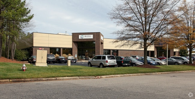
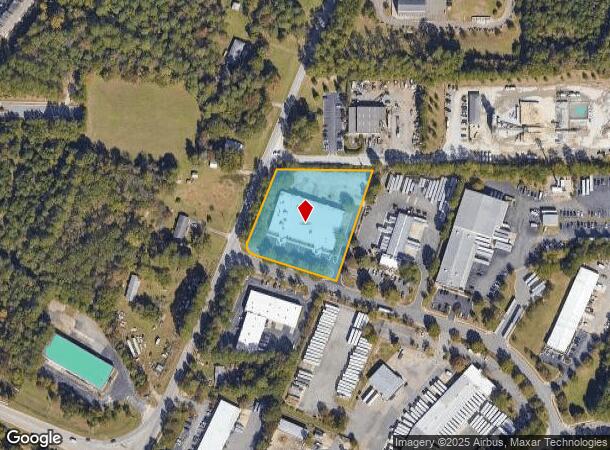
7516 Precision Dr, Raleigh, NC 27617

NEARBY LISTINGS FOR SALE OR LEASE
Property Detail
7516 Precision Dr
0768.02-97-3327-000
LO1 LEESBOROUGH INDUSTRIAL PK BM1986-225
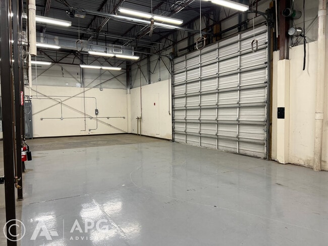
Warehouse
Wake
X
North Carolina
3720076800K
1
2025
2.21 AC
2025
Glenwood/Creedmoor
053717
Raleigh/Durham
28,688 SF
Raleigh-Cary, NC
DEMOGRAPHICS near 7516 Precision Dr
1 Mile
3 Mile
5 Mile
2024 Total Population
5,841
44,681
104,473
2029 Population
6,350
48,111
112,173
Pop Growth 2024-2029
+ 8.71%
+ 7.68%
+ 7.37%
Average Age
36
40
40
2024 Total Households
2,806
20,233
46,582
HH Growth 2024-2029
+ 8.95%
+ 7.76%
+ 7.52%
Median Household Inc
$92,282
$106,434
$102,189
Avg Household Size
2.10
2.20
2.20
2024 Avg HH Vehicles
2.00
2.00
2.00
Median Home Value
$312,739
$394,335
$398,317
Median Year Built
2009
2004
2002
Nearby Places
Map Layers
Map Styles
 Street
 Aerial
- Restaurants
- Banks
- Shops
- Fitness
- Groceries
PUBLIC TRANSPORTATION
AIRPORT
Raleigh-Durham International
DRIVE
WALK
Distance
Raleigh-Durham International
11 min
5.1 mi
SALE & LEASE HISTORY
LISTING DATE
SALE/LEASE

Sep 21, 2022
For Lease
May 25, 2022
For Lease
Aug 15, 2017
For Lease
Nearby Properties
Address
Land Use
TOTAL SIZE
Lot Size
Zoning
Address
Land Use
TOTAL SIZE
Lot Size
Zoning
24,907 SF
5,245.45 AC
R-4
Address
Land Use
TOTAL SIZE
Lot Size
Zoning
11,670 SF
41.27 AC
RS-M(D)
Address
Land Use
TOTAL SIZE
Lot Size
Zoning
15,252 SF
29.36 AC
RS-M
Address
Land Use
TOTAL SIZE
Lot Size
Zoning
543,777 SF
28.13 AC
RX-4
Address
Land Use
TOTAL SIZE
Lot Size
Zoning
385,640 SF
36.45 AC
RX-4
Address
Land Use
TOTAL SIZE
Lot Size
Zoning
441,283 SF
23.76 AC
PD
Address
Land Use
TOTAL SIZE
Lot Size
Zoning
431,534 SF
23.20 AC
RX-4
Address
Land Use
TOTAL SIZE
Lot Size
Zoning
370,540 SF
20.79 AC
PD
Address
Land Use
TOTAL SIZE
Lot Size
Zoning
287,656 SF
20.62 AC
PDR-H
Address
Land Use
TOTAL SIZE
Lot Size
Zoning
303,191 SF
19.18 AC
PD
Address
Land Use
TOTAL SIZE
Lot Size
Zoning
407,178 SF
22.57 AC
PD
Address
Land Use
TOTAL SIZE
Lot Size
Zoning
262,391 SF
8 AC
PD
Address
Land Use
TOTAL SIZE
Lot Size
Zoning
278,044 SF
17.79 AC
RX-3
Address
Land Use
TOTAL SIZE
Lot Size
Zoning
267,757 SF
35.89 AC
CX-5
Address
Land Use
TOTAL SIZE
Lot Size
Zoning
303,290 SF
14.48 AC
RX-3
Address
Land Use
TOTAL SIZE
Lot Size
Zoning
386,506 SF
55.21 AC
IH
Address
Land Use
TOTAL SIZE
Lot Size
Zoning
296,141 SF
14.38 AC
PD
Address
Land Use
TOTAL SIZE
Lot Size
Zoning
318,216 SF
6.36 AC
OX-7
Address
Land Use
TOTAL SIZE
Lot Size
Zoning
281,616 SF
18.69 AC
PD
Address
Land Use
TOTAL SIZE
Lot Size
Zoning
145,943 SF
34.96 AC
R-10
Address
Land Use
TOTAL SIZE
Lot Size
Zoning
197,578 SF
9.33 AC
CX-5
Address
Land Use
TOTAL SIZE
Lot Size
Zoning
216,039 SF
13.76 AC
RX-5
Address
Land Use
TOTAL SIZE
Lot Size
Zoning
194,040 SF
4.49 AC
PD
Address
Land Use
TOTAL SIZE
Lot Size
Zoning
268,855 SF
20.32 AC
RX-3
Address
Land Use
TOTAL SIZE
Lot Size
Zoning
201,831 SF
6.40 AC
PD
Address
Land Use
TOTAL SIZE
Lot Size
Zoning
245,158 SF
12.78 AC
RX-3
Address
Land Use
TOTAL SIZE
Lot Size
Zoning
303,212 SF
20.94 AC
RX-4
Address
Land Use
TOTAL SIZE
Lot Size
Zoning
244,868 SF
20.91 AC
IP
Address
Land Use
TOTAL SIZE
Lot Size
Zoning
151,786 SF
26.25 AC
R-4
Address
Land Use
TOTAL SIZE
Lot Size
Zoning
171,605 SF
6.70 AC
CX-3
The World's #1 Commercial Real Estate Marketplace
Connect with us
© 2026 CoStar Group
The information above has been obtained from sources believed reliable. While we do not doubt its accuracy we have not verified it and make no guarantee, warranty or representation about it. It is your responsibility to independently confirm its accuracy and completeness. Any projections, opinions, assumptions, or estimates used are for example only and do not represent the current or future performance of the property. The value of this transaction to you depends on tax and other factors which should be evaluated by your tax, financial, and legal advisors. You and your advisors should conduct a careful, independent investigation of the property to determine to your satisfaction the suitability of the property for your needs.