Property Record
7516 S Siwell Rd, Byram, MS 39272
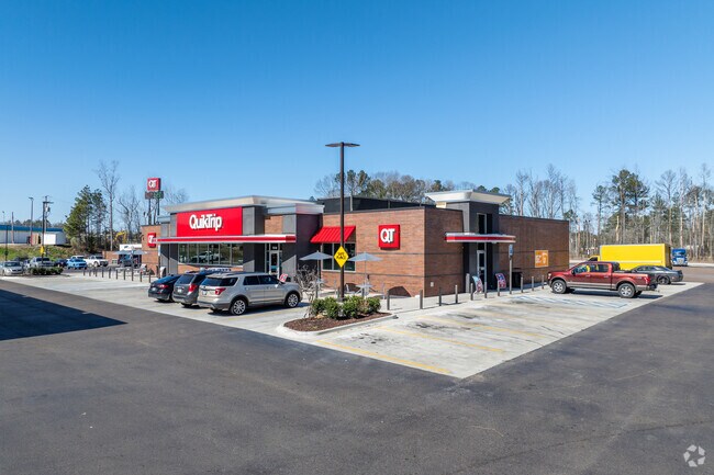

Property Detail
7516 S Siwell Rd
4851-0247-000
BEG NW COR SW 1/4 SE 1/4 SEC 13 E 990 FT S 1160 FT NWLY 355 FT NELY 320.79 FT NWLY 380 FT SWLY 320 FT NWLY 148 FT N 210 FT NWLY 212.5 FT N 525 FT TO POB IN SW 1/4 SE 1/4 SEC 13 T4 R1W TOWN OF BYRAM
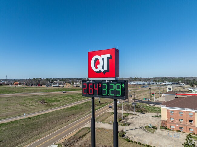
Servicestation
Hinds
AE The base floodplain where base flood elevations are provided. AE Zones are now used on new format FIRMs instead of A1-A30 Zones.
Mississippi
2024
14.33 AC
2025
Outlying Hinds County
011103
Jackson
8,286 SF
Jackson, MS
NEARBY LISTINGS FOR SALE OR LEASE
-
-
View all Byram listings for sale on LoopNet.com
DEMOGRAPHICS near 7516 S Siwell Rd
1 mile
3 mile
5 mile
2025 Total Population
2,407
13,387
26,483
2030 Population
2,221
12,638
25,335
Pop Growth 2025-2030
(7.73%)
(5.59%)
(4.33%)
Average Age
35
38
39
2025 Total Households
1,071
5,271
10,348
HH Growth 2025-2030
(8.03%)
(5.88%)
(4.57%)
Median Household Inc
$65,665
$77,720
$67,149
Avg Household Size
2.20
2.50
2.50
2025 Avg HH Vehicles
2.00
2.00
2.00
Median Home Value
$156,589
$181,950
$179,171
Median Year Built
1996
1995
1991
Nearby Places
Map Layers
Map Styles
 Street
 Aerial
Layers
 Traffic
 Biking
Places
Listings with unknown addresses are not visible on the map
- Restaurants
- Banks
- Shops
- Fitness
- Groceries
PUBLIC TRANSPORTATION
COMMUTER RAIL
Jackson (City of New Orleans - Amtrak)
Drive
Walk
Distance
Jackson (City of New Orleans - Amtrak)
13 min
9.7 mi
AIRPORT
Jackson-Medgar Wiley Evers International
Drive
Walk
Distance
Jackson-Medgar Wiley Evers International
26 min
18.3 mi
Freight Ports
Port of Greater Baton Rouge
Drive
Walk
Distance
Port of Greater Baton Rouge
185 min
166.7 mi
Nearby Properties
Address
Land Use
TOTAL SIZE
Lot Size
Zoning
Address
Land Use
TOTAL SIZE
Lot Size
Zoning
110,876 SF
8.80 AC
Address
Land Use
TOTAL SIZE
Lot Size
Zoning
489,330 SF
27.90 AC
Address
Land Use
TOTAL SIZE
Lot Size
Zoning
232,136 SF
16.06 AC
Address
Land Use
TOTAL SIZE
Lot Size
Zoning
190,029 SF
24.47 AC
Address
Land Use
TOTAL SIZE
Lot Size
Zoning
31,980 SF
9.10 AC
Address
Land Use
TOTAL SIZE
Lot Size
Zoning
229,741 SF
17.28 AC
Address
Land Use
TOTAL SIZE
Lot Size
Zoning
Address
Land Use
TOTAL SIZE
Lot Size
Zoning
34,900 SF
6.60 AC
Address
Land Use
TOTAL SIZE
Lot Size
Zoning
224,684 SF
18 AC
Address
Land Use
TOTAL SIZE
Lot Size
Zoning
8.90 AC
Address
Land Use
TOTAL SIZE
Lot Size
Zoning
136,190 SF
10.06 AC
Address
Land Use
TOTAL SIZE
Lot Size
Zoning
351,384 SF
16.69 AC
Address
Land Use
TOTAL SIZE
Lot Size
Zoning
45.60 AC
Address
Land Use
TOTAL SIZE
Lot Size
Zoning
134,417 SF
10 AC
Address
Land Use
TOTAL SIZE
Lot Size
Zoning
18,200 SF
1.66 AC
Address
Land Use
TOTAL SIZE
Lot Size
Zoning
25,880 SF
5.47 AC
Address
Land Use
TOTAL SIZE
Lot Size
Zoning
230,745 SF
18.40 AC
Address
Land Use
TOTAL SIZE
Lot Size
Zoning
Address
Land Use
TOTAL SIZE
Lot Size
Zoning
Address
Land Use
TOTAL SIZE
Lot Size
Zoning
173,863 SF
30.67 AC
Address
Land Use
TOTAL SIZE
Lot Size
Zoning
81,983 SF
7.20 AC
Address
Land Use
TOTAL SIZE
Lot Size
Zoning
Address
Land Use
TOTAL SIZE
Lot Size
Zoning
222,160 SF
37.66 AC
Address
Land Use
TOTAL SIZE
Lot Size
Zoning
94,621 SF
23.37 AC
Address
Land Use
TOTAL SIZE
Lot Size
Zoning
29.50 AC
Address
Land Use
TOTAL SIZE
Lot Size
Zoning
68,315 SF
6.36 AC
Address
Land Use
TOTAL SIZE
Lot Size
Zoning
Address
Land Use
TOTAL SIZE
Lot Size
Zoning
12,500 SF
3.40 AC
Address
Land Use
TOTAL SIZE
Lot Size
Zoning
11,260 SF
1.86 AC
Address
Land Use
TOTAL SIZE
Lot Size
Zoning
37,542 SF
3.50 AC
The World's #1 Commercial Real Estate Marketplace
Connect with us
© 2026 CoStar Group
The information above has been obtained from sources believed reliable. While we do not doubt its accuracy we have not verified it and make no guarantee, warranty or representation about it. It is your responsibility to independently confirm its accuracy and completeness. Any projections, opinions, assumptions, or estimates used are for example only and do not represent the current or future performance of the property. The value of this transaction to you depends on tax and other factors which should be evaluated by your tax, financial, and legal advisors. You and your advisors should conduct a careful, independent investigation of the property to determine to your satisfaction the suitability of the property for your needs.