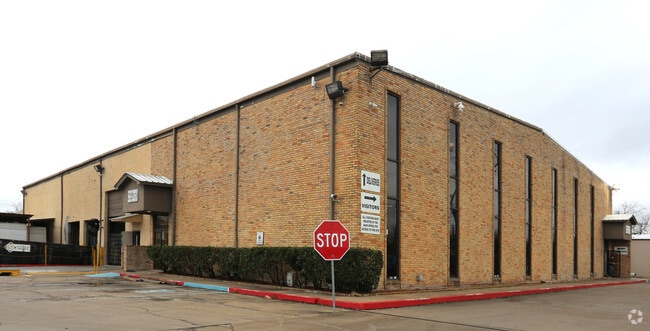
Property Record
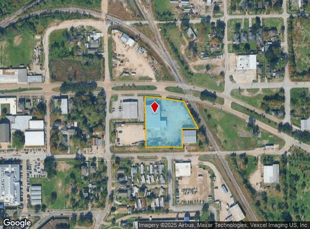
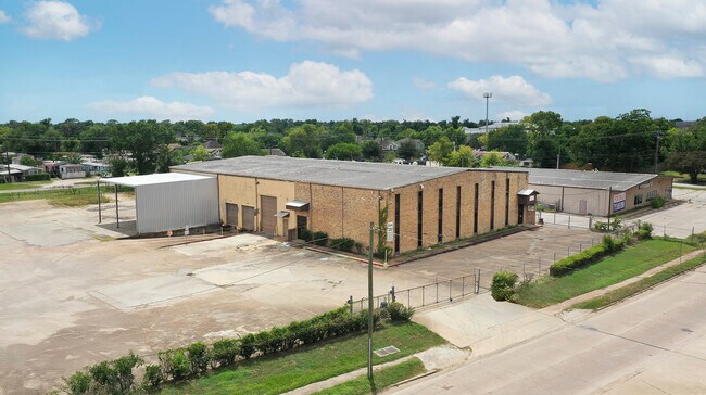
7520 Lawndale St, Houston, TX 77012

Current Lease Availabilities
NEARBY LISTINGS FOR SALE OR LEASE
Property Detail
7520 Lawndale St
1335150010001
Gorham Export Packing
Warehouse
RES A BLK 1 GORHAM EXPORT PACKING
X
Harris
48201C0885N
Texas
2024
2.07 AC
2025
Southeast Outer Loop
311502
Houston
15,300 SF
Houston-The Woodlands-Sugar Land, TX
DEMOGRAPHICS near 7520 Lawndale St
1 Mile
3 Mile
5 Mile
2024 Total Population
18,765
112,919
314,536
2029 Population
19,279
115,974
323,941
Pop Growth 2024-2029
+ 2.74%
+ 2.71%
+ 2.99%
Average Age
37
37
36
2024 Total Households
6,101
37,637
106,268
HH Growth 2024-2029
+ 2.88%
+ 2.73%
+ 3.18%
Median Household Inc
$42,081
$39,438
$41,772
Avg Household Size
3.00
2.90
2.80
2024 Avg HH Vehicles
2.00
2.00
2.00
Median Home Value
$145,228
$146,738
$148,506
Median Year Built
1950
1957
1959
Nearby Places
- Restaurants
- Banks
- Shops
- Fitness
- Groceries
PUBLIC TRANSPORTATION
COMMUTER RAIL
Houston (Sunset Limited - Amtrak)
DRIVE
WALK
Distance
Houston (Sunset Limited - Amtrak)
13 min
8.1 mi
AIRPORT
William P Hobby
DRIVE
WALK
Distance
William P Hobby
17 min
7.7 mi
George Bush Intcntl/Houston
DRIVE
WALK
Distance
George Bush Intcntl/Houston
34 min
25.9 mi
Freight Ports
Port of Houston
DRIVE
WALK
Distance
Port of Houston
10 min
4.3 mi
Nearby Properties
Address
Land Use
TOTAL SIZE
Lot Size
Zoning
Address
Land Use
TOTAL SIZE
Lot Size
Zoning
65.22 AC
Address
Land Use
TOTAL SIZE
Lot Size
Zoning
256.70 AC
Address
Land Use
TOTAL SIZE
Lot Size
Zoning
108.84 AC
Address
Land Use
TOTAL SIZE
Lot Size
Zoning
1,392,720 SF
83.75 AC
Address
Land Use
TOTAL SIZE
Lot Size
Zoning
4.26 AC
Address
Land Use
TOTAL SIZE
Lot Size
Zoning
2,275,058 SF
24.47 AC
Address
Land Use
TOTAL SIZE
Lot Size
Zoning
403,242 SF
46.18 AC
Address
Land Use
TOTAL SIZE
Lot Size
Zoning
1,171,276 SF
44.19 AC
Address
Land Use
TOTAL SIZE
Lot Size
Zoning
115.83 AC
Address
Land Use
TOTAL SIZE
Lot Size
Zoning
198,023 SF
17.87 AC
Address
Land Use
TOTAL SIZE
Lot Size
Zoning
33.97 AC
Address
Land Use
TOTAL SIZE
Lot Size
Zoning
901,984 SF
59.37 AC
Address
Land Use
TOTAL SIZE
Lot Size
Zoning
504,018 SF
37.16 AC
Address
Land Use
TOTAL SIZE
Lot Size
Zoning
261.10 AC
Address
Land Use
TOTAL SIZE
Lot Size
Zoning
107.07 AC
Address
Land Use
TOTAL SIZE
Lot Size
Zoning
331,196 SF
40.14 AC
Address
Land Use
TOTAL SIZE
Lot Size
Zoning
985,528 SF
22.64 AC
Address
Land Use
TOTAL SIZE
Lot Size
Zoning
232,915 SF
7.89 AC
Address
Land Use
TOTAL SIZE
Lot Size
Zoning
267,844 SF
10.98 AC
Address
Land Use
TOTAL SIZE
Lot Size
Zoning
194,296 SF
15.13 AC
Address
Land Use
TOTAL SIZE
Lot Size
Zoning
224,084 SF
72.45 AC
Address
Land Use
TOTAL SIZE
Lot Size
Zoning
113,688 SF
4 AC
Address
Land Use
TOTAL SIZE
Lot Size
Zoning
78,073 SF
5.45 AC
Address
Land Use
TOTAL SIZE
Lot Size
Zoning
207,196 SF
16.55 AC
Address
Land Use
TOTAL SIZE
Lot Size
Zoning
241,999 SF
8.46 AC
Address
Land Use
TOTAL SIZE
Lot Size
Zoning
54,077 SF
5.06 AC
Address
Land Use
TOTAL SIZE
Lot Size
Zoning
67,891 SF
51.16 AC
Address
Land Use
TOTAL SIZE
Lot Size
Zoning
Address
Land Use
TOTAL SIZE
Lot Size
Zoning
214,046 SF
20.28 AC
Address
Land Use
TOTAL SIZE
Lot Size
Zoning
445,535 SF
36.94 AC
The World's #1 Commercial Real Estate Marketplace
Connect with us
© 2025 CoStar Group
The information above has been obtained from sources believed reliable. While we do not doubt its accuracy we have not verified it and make no guarantee, warranty or representation about it. It is your responsibility to independently confirm its accuracy and completeness. Any projections, opinions, assumptions, or estimates used are for example only and do not represent the current or future performance of the property. The value of this transaction to you depends on tax and other factors which should be evaluated by your tax, financial, and legal advisors. You and your advisors should conduct a careful, independent investigation of the property to determine to your satisfaction the suitability of the property for your needs.