Property Record
7524 Fairfield Rd, Columbia, SC 29203
NEARBY LISTINGS FOR SALE OR LEASE
-
-
View all Columbia listings for lease on LoopNet.com
Property Detail
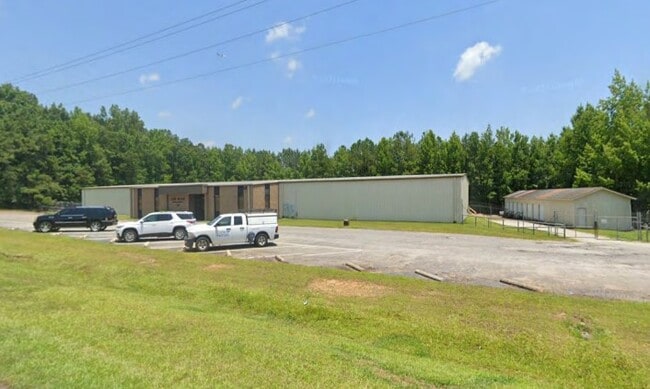
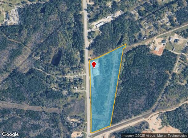
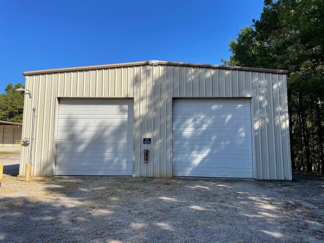
7524 Fairfield Rd
12000-03-04
#SU #PR
Commercialnec
Richland
X
South Carolina
45079C0232L
19.20 AC
2025
North Columbia
2024
Columbia
010200
Columbia, SC
12,450 SF
DEMOGRAPHICS near 7524 Fairfield Rd
1 Mile
3 Mile
5 Mile
2024 Total Population
892
11,530
56,611
2029 Population
909
11,776
57,836
Pop Growth 2024-2029
+ 1.91%
+ 2.13%
+ 2.16%
Average Age
41
42
39
2024 Total Households
348
4,455
24,073
HH Growth 2024-2029
+ 2.01%
+ 2.15%
+ 2.21%
Median Household Inc
$50,857
$50,191
$40,383
Avg Household Size
2.50
2.50
2.30
2024 Avg HH Vehicles
2.00
2.00
2.00
Median Home Value
$113,158
$139,793
$143,497
Median Year Built
1978
1977
1976
Nearby Places
Map Layers
Map Styles
 Street
 Aerial
- Restaurants
- Banks
- Shops
- Fitness
- Groceries
PUBLIC TRANSPORTATION
COMMUTER RAIL
Columbia Amtrak Station (Silver Star - Amtrak)
DRIVE
WALK
Distance
Columbia Amtrak Station (Silver Star - Amtrak)
17 min
8.8 mi
AIRPORT
Columbia Metro
DRIVE
WALK
Distance
Columbia Metro
33 min
19.1 mi
Freight Ports
North Charleston Terminal
DRIVE
WALK
Distance
North Charleston Terminal
132 min
115.4 mi
SALE & LEASE HISTORY
LISTING DATE
SALE/LEASE

Feb 01, 2024
For Lease
Feb 01, 2023
For Sale
Nearby Properties
Address
Land Use
TOTAL SIZE
Lot Size
Zoning
Address
Land Use
TOTAL SIZE
Lot Size
Zoning
48,289 SF
5.90 AC
D-1
Address
Land Use
TOTAL SIZE
Lot Size
Zoning
39,041 SF
4.12 AC
M-1
Address
Land Use
TOTAL SIZE
Lot Size
Zoning
25,408 SF
13.58 AC
C-3
Address
Land Use
TOTAL SIZE
Lot Size
Zoning
12,000 SF
8.47 AC
M-1
Address
Land Use
TOTAL SIZE
Lot Size
Zoning
245.08 AC
PDD
Address
Land Use
TOTAL SIZE
Lot Size
Zoning
48,750 SF
4.46 AC
M-1
Address
Land Use
TOTAL SIZE
Lot Size
Zoning
50,850 SF
4.98 AC
M-1
Address
Land Use
TOTAL SIZE
Lot Size
Zoning
4,830 SF
11.34 AC
RU
Address
Land Use
TOTAL SIZE
Lot Size
Zoning
10,168 SF
172.52 AC
PDD
Address
Land Use
TOTAL SIZE
Lot Size
Zoning
30,400 SF
6.01 AC
C-3
Address
Land Use
TOTAL SIZE
Lot Size
Zoning
15,628 SF
4.55 AC
RS-HD
Address
Land Use
TOTAL SIZE
Lot Size
Zoning
7,348 SF
1.08 AC
OI
Address
Land Use
TOTAL SIZE
Lot Size
Zoning
16,000 SF
1.90 AC
M-1
Address
Land Use
TOTAL SIZE
Lot Size
Zoning
1,940 SF
36.50 AC
RU
Address
Land Use
TOTAL SIZE
Lot Size
Zoning
34,200 SF
3.16 AC
M-1
Address
Land Use
TOTAL SIZE
Lot Size
Zoning
42,944 SF
6.53 AC
M-1
Address
Land Use
TOTAL SIZE
Lot Size
Zoning
52,134 SF
7.21 AC
M-1
Address
Land Use
TOTAL SIZE
Lot Size
Zoning
10,775 SF
4.12 AC
OI
Address
Land Use
TOTAL SIZE
Lot Size
Zoning
13,040 SF
5.39 AC
RU
Address
Land Use
TOTAL SIZE
Lot Size
Zoning
69.49 AC
OI
Address
Land Use
TOTAL SIZE
Lot Size
Zoning
16,500 SF
7.21 AC
HI
Address
Land Use
TOTAL SIZE
Lot Size
Zoning
22,256 SF
1.70 AC
M-1
Address
Land Use
TOTAL SIZE
Lot Size
Zoning
14,520 SF
1.03 AC
M-1
Address
Land Use
TOTAL SIZE
Lot Size
Zoning
15,260 SF
3.05 AC
LI
Address
Land Use
TOTAL SIZE
Lot Size
Zoning
2,872 SF
1.19 AC
C-3
Address
Land Use
TOTAL SIZE
Lot Size
Zoning
9,870 SF
1.90 AC
GC
Address
Land Use
TOTAL SIZE
Lot Size
Zoning
8,280 SF
6.70 AC
C-3
Address
Land Use
TOTAL SIZE
Lot Size
Zoning
8,400 SF
1.71 AC
M-1
Address
Land Use
TOTAL SIZE
Lot Size
Zoning
10,900 SF
3.04 AC
M-1
Address
Land Use
TOTAL SIZE
Lot Size
Zoning
35,000 SF
3.50 AC
M-1
The World's #1 Commercial Real Estate Marketplace
Connect with us
© 2026 CoStar Group
The information above has been obtained from sources believed reliable. While we do not doubt its accuracy we have not verified it and make no guarantee, warranty or representation about it. It is your responsibility to independently confirm its accuracy and completeness. Any projections, opinions, assumptions, or estimates used are for example only and do not represent the current or future performance of the property. The value of this transaction to you depends on tax and other factors which should be evaluated by your tax, financial, and legal advisors. You and your advisors should conduct a careful, independent investigation of the property to determine to your satisfaction the suitability of the property for your needs.