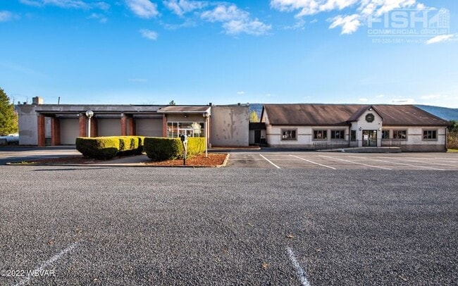
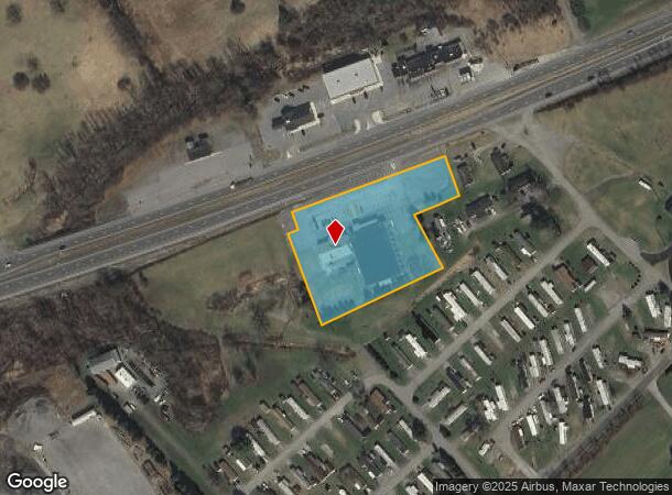
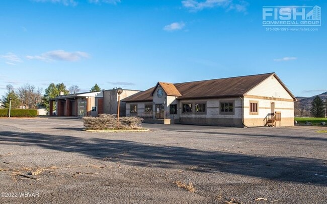
Property Record
7525 N Route 220 Hwy, Linden, PA 17744
NEARBY LISTINGS FOR SALE OR LEASE
Property Detail
7525 N Route 220 Hwy
Bowlingalley
Lycoming
X
Pennsylvania
42081C0423F
2.50 AC
2025
Pennsylvania Central Area
2025
Other Market Areas
011301
Williamsport, PA
4,070 SF
60-367.0-0125.F-000
DEMOGRAPHICS near 7525 N Route 220 Hwy
1 Mile
3 Mile
5 Mile
2024 Total Population
723
2,690
10,237
2029 Population
712
2,638
10,072
Pop Growth 2024-2029
(1.52%)
(1.93%)
(1.61%)
Average Age
45
45
43
2024 Total Households
320
1,123
4,160
HH Growth 2024-2029
(1.56%)
(2.05%)
(1.73%)
Median Household Inc
$56,999
$60,265
$62,654
Avg Household Size
2.20
2.30
2.40
2024 Avg HH Vehicles
2.00
2.00
2.00
Median Home Value
$161,637
$168,159
$162,690
Median Year Built
1979
1971
1960
Nearby Places
- Restaurants
- Banks
- Shops
- Fitness
- Groceries
SALE & LEASE HISTORY
LISTING DATE
SALE/LEASE

Dec 07, 2022
For Sale
Dec 06, 2022
For Sale
Nearby Properties
Address
Land Use
TOTAL SIZE
Lot Size
Zoning
Address
Land Use
TOTAL SIZE
Lot Size
Zoning
1,008 SF
119.49 AC
AGR
Address
Land Use
TOTAL SIZE
Lot Size
Zoning
1,904 SF
34.40 AC
4COR
Address
Land Use
TOTAL SIZE
Lot Size
Zoning
6,120 SF
12.85 AC
Address
Land Use
TOTAL SIZE
Lot Size
Zoning
1,872 SF
71.81 AC
5FWR
Address
Land Use
TOTAL SIZE
Lot Size
Zoning
4,904 SF
2.80 AC
04COB
Address
Land Use
TOTAL SIZE
Lot Size
Zoning
11,004 SF
5.01 AC
COMP
Address
Land Use
TOTAL SIZE
Lot Size
Zoning
3,420 SF
10 AC
Address
Land Use
TOTAL SIZE
Lot Size
Zoning
1,482 SF
2.62 AC
4AGP
Address
Land Use
TOTAL SIZE
Lot Size
Zoning
1,920 SF
2.06 AC
5COP
Address
Land Use
TOTAL SIZE
Lot Size
Zoning
2,423 SF
14.39 AC
5FWR
Address
Land Use
TOTAL SIZE
Lot Size
Zoning
3,097 SF
1.12 AC
4COB
Address
Land Use
TOTAL SIZE
Lot Size
Zoning
4,284 SF
124.60 AC
4AGR
Address
Land Use
TOTAL SIZE
Lot Size
Zoning
3,856 SF
218.83 AC
5AGR
Address
Land Use
TOTAL SIZE
Lot Size
Zoning
6,362 SF
8.95 AC
AGR
Address
Land Use
TOTAL SIZE
Lot Size
Zoning
4,369 SF
1.83 AC
RESR
Address
Land Use
TOTAL SIZE
Lot Size
Zoning
1,968 SF
3.70 AC
4RER
Address
Land Use
TOTAL SIZE
Lot Size
Zoning
3,945 SF
1.16 AC
4COB
Address
Land Use
TOTAL SIZE
Lot Size
Zoning
3,136 SF
17.15 AC
5RER
Address
Land Use
TOTAL SIZE
Lot Size
Zoning
2,928 SF
8.64 AC
04AGR
Address
Land Use
TOTAL SIZE
Lot Size
Zoning
2,280 SF
205.85 AC
5AGR
Address
Land Use
TOTAL SIZE
Lot Size
Zoning
1,468 SF
146.51 AC
5FWR
Address
Land Use
TOTAL SIZE
Lot Size
Zoning
1,680 SF
154 AC
5AGR
Address
Land Use
TOTAL SIZE
Lot Size
Zoning
520 SF
11.60 AC
04AGR
Address
Land Use
TOTAL SIZE
Lot Size
Zoning
7,200 SF
2.26 AC
AGR
Address
Land Use
TOTAL SIZE
Lot Size
Zoning
12,358 SF
11.68 AC
FWR
Address
Land Use
TOTAL SIZE
Lot Size
Zoning
3,936 SF
74.47 AC
5AGR
Address
Land Use
TOTAL SIZE
Lot Size
Zoning
2,621 SF
15.02 AC
05AGR
Address
Land Use
TOTAL SIZE
Lot Size
Zoning
3,755 SF
33.82 AC
5AGR
The World's #1 Commercial Real Estate Marketplace
Connect with us
© 2025 CoStar Group
The information above has been obtained from sources believed reliable. While we do not doubt its accuracy we have not verified it and make no guarantee, warranty or representation about it. It is your responsibility to independently confirm its accuracy and completeness. Any projections, opinions, assumptions, or estimates used are for example only and do not represent the current or future performance of the property. The value of this transaction to you depends on tax and other factors which should be evaluated by your tax, financial, and legal advisors. You and your advisors should conduct a careful, independent investigation of the property to determine to your satisfaction the suitability of the property for your needs.