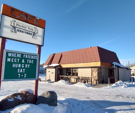
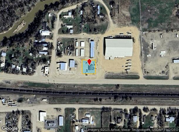
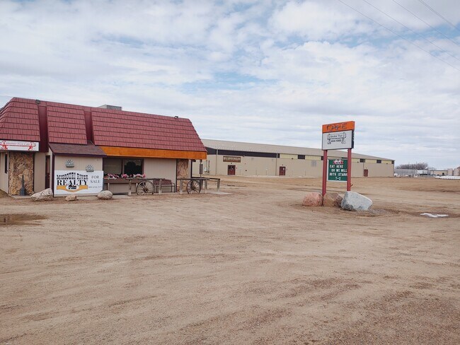
Property Record
745 N 1St St E, Malta, MT 59538
NEARBY LISTINGS FOR SALE OR LEASE
-
-
View all Malta listings for sale on LoopNet.com
Property Detail
745 N 1St St E
Other Market Areas
Second Northside Add - Malta
11423917207060000
SECOND NORTHSIDE ADD - MALTA, S17, T30 N, R30 E, LOT 5 ACCORDING TO PLAT 52 AND LOT 4B ACCORDING TO AMENDED PLAT 78 AND COS
Restaurantbuilding
Phillips
2025
Montana
2025
5-6,4b
060200
0.33 AC
1,394 SF
Montana Other Areas
DEMOGRAPHICS near 745 N 1St St E
1 Mile
3 Mile
5 Mile
2024 Total Population
1,778
2,255
2,351
2029 Population
1,790
2,267
2,362
Pop Growth 2024-2029
+ 0.67%
+ 0.53%
+ 0.47%
Average Age
44
44
44
2024 Total Households
808
1,017
1,054
HH Growth 2024-2029
+ 0.62%
+ 0.49%
+ 0.47%
Median Household Inc
$52,661
$52,105
$51,859
Avg Household Size
2.10
2.10
2.20
2024 Avg HH Vehicles
2.00
2.00
2.00
Median Home Value
$116,667
$119,262
$121,400
Median Year Built
1957
1958
1958
Nearby Places
Map Layers
Map Styles
 Street
 Aerial
- Restaurants
- Banks
- Shops
- Fitness
- Groceries
PUBLIC TRANSPORTATION
COMMUTER RAIL
DRIVE
WALK
Distance
1 min
17 min
0.5 mi
SALE & LEASE HISTORY
LISTING DATE
SALE/LEASE

Jul 06, 2018
For Sale
Jan 16, 2023
For Sale
Nearby Properties
Address
Land Use
TOTAL SIZE
Lot Size
Zoning
Address
Land Use
TOTAL SIZE
Lot Size
Zoning
22,184 SF
1.98 AC
1
Address
Land Use
TOTAL SIZE
Lot Size
Zoning
13,192 SF
1.15 AC
1
Address
Land Use
TOTAL SIZE
Lot Size
Zoning
15,144 SF
5.83 AC
1
Address
Land Use
TOTAL SIZE
Lot Size
Zoning
18,114 SF
4.94 AC
Address
Land Use
TOTAL SIZE
Lot Size
Zoning
1,600 SF
160 AC
1
Address
Land Use
TOTAL SIZE
Lot Size
Zoning
4,352 SF
0.32 AC
Address
Land Use
TOTAL SIZE
Lot Size
Zoning
7,200 SF
1.62 AC
Address
Land Use
TOTAL SIZE
Lot Size
Zoning
1,680 SF
3.96 AC
1
Address
Land Use
TOTAL SIZE
Lot Size
Zoning
37,228 SF
10 AC
1
Address
Land Use
TOTAL SIZE
Lot Size
Zoning
4,847 SF
67.31 AC
1
Address
Land Use
TOTAL SIZE
Lot Size
Zoning
8,640 SF
0.40 AC
1
Address
Land Use
TOTAL SIZE
Lot Size
Zoning
7,923 SF
0.34 AC
Address
Land Use
TOTAL SIZE
Lot Size
Zoning
20,054 SF
0.46 AC
1
Address
Land Use
TOTAL SIZE
Lot Size
Zoning
41,515 SF
4.76 AC
1
Address
Land Use
TOTAL SIZE
Lot Size
Zoning
8,280 SF
0.79 AC
1
Address
Land Use
TOTAL SIZE
Lot Size
Zoning
12,000 SF
16.02 AC
1
Address
Land Use
TOTAL SIZE
Lot Size
Zoning
11,990 SF
1.15 AC
1
Address
Land Use
TOTAL SIZE
Lot Size
Zoning
6,000 SF
0.48 AC
1
Address
Land Use
TOTAL SIZE
Lot Size
Zoning
9,096 SF
0.11 AC
1
Address
Land Use
TOTAL SIZE
Lot Size
Zoning
4,800 SF
0.62 AC
Address
Land Use
TOTAL SIZE
Lot Size
Zoning
4,082 SF
0.34 AC
1
Address
Land Use
TOTAL SIZE
Lot Size
Zoning
5,275 SF
0.45 AC
1
Address
Land Use
TOTAL SIZE
Lot Size
Zoning
6,400 SF
1.78 AC
1
Address
Land Use
TOTAL SIZE
Lot Size
Zoning
7,636 SF
0.99 AC
1
Address
Land Use
TOTAL SIZE
Lot Size
Zoning
17,284 SF
0.80 AC
1
Address
Land Use
TOTAL SIZE
Lot Size
Zoning
10,488 SF
1.06 AC
Address
Land Use
TOTAL SIZE
Lot Size
Zoning
2,968 SF
0.72 AC
1
Address
Land Use
TOTAL SIZE
Lot Size
Zoning
3,500 SF
0.32 AC
1
Address
Land Use
TOTAL SIZE
Lot Size
Zoning
3,200 SF
0.35 AC
1
Address
Land Use
TOTAL SIZE
Lot Size
Zoning
6,408 SF
0.77 AC
1
The World's #1 Commercial Real Estate Marketplace
Connect with us
© 2026 CoStar Group
The information above has been obtained from sources believed reliable. While we do not doubt its accuracy we have not verified it and make no guarantee, warranty or representation about it. It is your responsibility to independently confirm its accuracy and completeness. Any projections, opinions, assumptions, or estimates used are for example only and do not represent the current or future performance of the property. The value of this transaction to you depends on tax and other factors which should be evaluated by your tax, financial, and legal advisors. You and your advisors should conduct a careful, independent investigation of the property to determine to your satisfaction the suitability of the property for your needs.