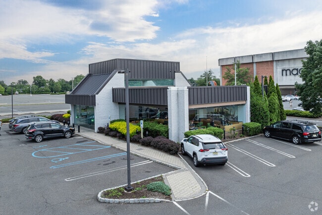
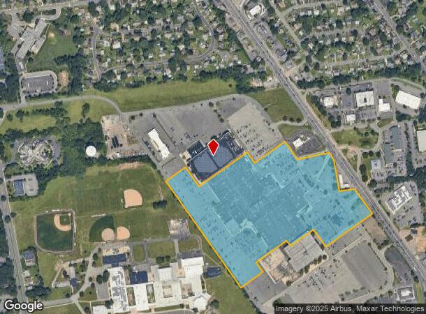
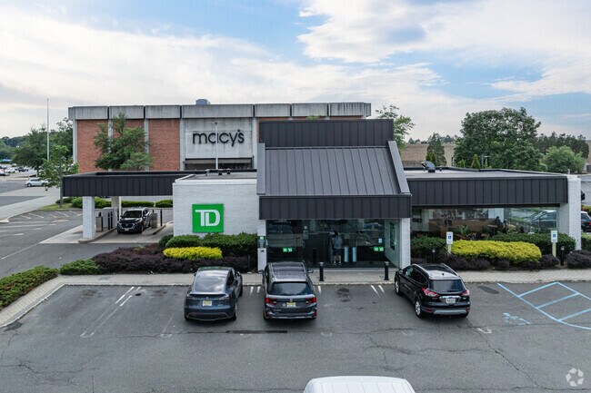
Property Record
753 State Route 18, East Brunswick, NJ 08816
NEARBY LISTINGS FOR SALE OR LEASE
-
-
-
-
-
No Photo
-
-
-
View all East Brunswick listings for sale on LoopNet.com
Property Detail
753 State Route 18
04-00131-0000-00020-01
24.9600
Regionalshoppingcenterormallwithanchorstore
Middlesex
X
New Jersey
34023C0142F
20.1
2024
24.96 AC
2025
Brunswick
006701
Northern New Jersey
282,731 SF
Lakewood-New Brunswick, NJ
DEMOGRAPHICS near 753 State Route 18
1 Mile
3 Mile
5 Mile
2024 Total Population
12,408
85,748
177,017
2029 Population
12,354
85,308
176,235
Pop Growth 2024-2029
(0.44%)
(0.51%)
(0.44%)
Average Age
41
41
41
2024 Total Households
4,055
30,344
62,899
HH Growth 2024-2029
(0.49%)
(0.59%)
(0.53%)
Median Household Inc
$132,647
$104,613
$105,466
Avg Household Size
3.00
2.80
2.70
2024 Avg HH Vehicles
2.00
2.00
2.00
Median Home Value
$436,133
$403,168
$407,781
Median Year Built
1964
1968
1969
Nearby Places
Map Layers
Map Styles
 Street
 Aerial
- Restaurants
- Banks
- Shops
- Fitness
- Groceries
PUBLIC TRANSPORTATION
COMMUTER RAIL
New Brunswick (Northeast Corridor Line - NJ Transit Commuter Rail (NJ Transit))
DRIVE
WALK
Distance
New Brunswick (Northeast Corridor Line - NJ Transit Commuter Rail (NJ Transit))
13 min
7.2 mi
Jersey Avenue (Northeast Corridor Line - NJ Transit Commuter Rail (NJ Transit))
DRIVE
WALK
Distance
Jersey Avenue (Northeast Corridor Line - NJ Transit Commuter Rail (NJ Transit))
21 min
9.2 mi
AIRPORT
Newark Liberty International
DRIVE
WALK
Distance
Newark Liberty International
41 min
29.3 mi
Trenton Mercer
DRIVE
WALK
Distance
Trenton Mercer
50 min
34.5 mi
Freight Ports
New York Container Terminal
DRIVE
WALK
Distance
New York Container Terminal
34 min
24.4 mi
Nearby Properties
Address
Land Use
TOTAL SIZE
Lot Size
Zoning
Address
Land Use
TOTAL SIZE
Lot Size
Zoning
176.53 AC
G1
Address
Land Use
TOTAL SIZE
Lot Size
Zoning
Address
Land Use
TOTAL SIZE
Lot Size
Zoning
81,600 SF
49.89 AC
LI
Address
Land Use
TOTAL SIZE
Lot Size
Zoning
Address
Land Use
TOTAL SIZE
Lot Size
Zoning
24.19 AC
R100
Address
Land Use
TOTAL SIZE
Lot Size
Zoning
160,986 SF
60.24 AC
Address
Land Use
TOTAL SIZE
Lot Size
Zoning
315,200 SF
22.76 AC
LI
Address
Land Use
TOTAL SIZE
Lot Size
Zoning
7.41 AC
MXD
Address
Land Use
TOTAL SIZE
Lot Size
Zoning
245,980 SF
54.02 AC
OP1
Address
Land Use
TOTAL SIZE
Lot Size
Zoning
367,200 SF
34.22 AC
HC2
Address
Land Use
TOTAL SIZE
Lot Size
Zoning
14.34 AC
R100
Address
Land Use
TOTAL SIZE
Lot Size
Zoning
7,701 SF
38.78 AC
R30
Address
Land Use
TOTAL SIZE
Lot Size
Zoning
8,512 SF
65.36 AC
MH
Address
Land Use
TOTAL SIZE
Lot Size
Zoning
19.97 AC
P
Address
Land Use
TOTAL SIZE
Lot Size
Zoning
7,801 SF
9.26 AC
CN
Address
Land Use
TOTAL SIZE
Lot Size
Zoning
47.57 AC
SED
Address
Land Use
TOTAL SIZE
Lot Size
Zoning
12.01 AC
Address
Land Use
TOTAL SIZE
Lot Size
Zoning
93,180 SF
0.65 AC
C-4
Address
Land Use
TOTAL SIZE
Lot Size
Zoning
0.36 AC
R75
Address
Land Use
TOTAL SIZE
Lot Size
Zoning
118,800 SF
8.33 AC
LI
Address
Land Use
TOTAL SIZE
Lot Size
Zoning
29.98 AC
O1
Address
Land Use
TOTAL SIZE
Lot Size
Zoning
32.96 AC
MXD2
Address
Land Use
TOTAL SIZE
Lot Size
Zoning
64,544 SF
7.62 AC
C-2
Address
Land Use
TOTAL SIZE
Lot Size
Zoning
Address
Land Use
TOTAL SIZE
Lot Size
Zoning
219,430 SF
16.50 AC
HC2
Address
Land Use
TOTAL SIZE
Lot Size
Zoning
13.01 AC
HC3
Address
Land Use
TOTAL SIZE
Lot Size
Zoning
62.23 AC
R2
Address
Land Use
TOTAL SIZE
Lot Size
Zoning
8.95 AC
R100
Address
Land Use
TOTAL SIZE
Lot Size
Zoning
2,880 SF
50.86 AC
H1
The World's #1 Commercial Real Estate Marketplace
Connect with us
© 2026 CoStar Group
The information above has been obtained from sources believed reliable. While we do not doubt its accuracy we have not verified it and make no guarantee, warranty or representation about it. It is your responsibility to independently confirm its accuracy and completeness. Any projections, opinions, assumptions, or estimates used are for example only and do not represent the current or future performance of the property. The value of this transaction to you depends on tax and other factors which should be evaluated by your tax, financial, and legal advisors. You and your advisors should conduct a careful, independent investigation of the property to determine to your satisfaction the suitability of the property for your needs.