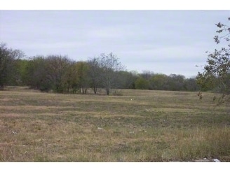
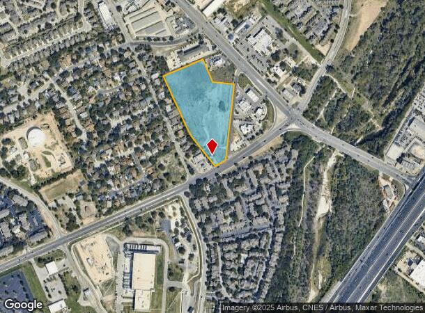
Property Record
7531 Potranco Rd, San Antonio, TX 78251
NEARBY LISTINGS FOR SALE OR LEASE
Property Detail
7531 Potranco Rd
San Antonio-New Braunfels, TX
Ncb 18285 (Aaa Storage Potranco)
18285-001-0210
NCB 18285 (AAA STORAGE POTRANCO), BLOCK 1 LOT 31 2025 NEW PER PLAT 20003/1966 FILED 8/23/2024
Vacantlandnec
Bexar
X
Texas
48029C0360G
31
2024
9.22 AC
2025
Far West
171926
San Antonio
55,870 SF
DEMOGRAPHICS near 7531 Potranco Rd
1 Mile
3 Mile
5 Mile
2024 Total Population
12,496
113,495
322,821
2029 Population
13,082
120,062
341,237
Pop Growth 2024-2029
+ 4.69%
+ 5.79%
+ 5.70%
Average Age
34
36
36
2024 Total Households
5,442
42,079
117,185
HH Growth 2024-2029
+ 4.87%
+ 6.00%
+ 5.92%
Median Household Inc
$47,187
$56,899
$57,086
Avg Household Size
2.30
2.60
2.70
2024 Avg HH Vehicles
2.00
2.00
2.00
Median Home Value
$190,322
$175,180
$172,936
Median Year Built
1993
1990
1986
Nearby Places
Map Layers
Map Styles
 Street
 Aerial
- Restaurants
- Banks
- Shops
- Fitness
- Groceries
PUBLIC TRANSPORTATION
AIRPORT
San Antonio International
DRIVE
WALK
Distance
San Antonio International
16 min
12.0 mi
Freight Ports
Calhoun Port
DRIVE
WALK
Distance
Calhoun Port
194 min
157.4 mi
SALE & LEASE HISTORY
LISTING DATE
SALE/LEASE

May 24, 2021
For Sale
Nearby Properties
Address
Land Use
TOTAL SIZE
Lot Size
Zoning
Address
Land Use
TOTAL SIZE
Lot Size
Zoning
486,228 SF
50.05 AC
Address
Land Use
TOTAL SIZE
Lot Size
Zoning
339,795 SF
24.27 AC
Address
Land Use
TOTAL SIZE
Lot Size
Zoning
469,808 SF
36 AC
Address
Land Use
TOTAL SIZE
Lot Size
Zoning
593,760 SF
69.28 AC
Address
Land Use
TOTAL SIZE
Lot Size
Zoning
236,594 SF
25.35 AC
Address
Land Use
TOTAL SIZE
Lot Size
Zoning
185,751 SF
21.60 AC
Address
Land Use
TOTAL SIZE
Lot Size
Zoning
171,142 SF
21.60 AC
Address
Land Use
TOTAL SIZE
Lot Size
Zoning
370,870 SF
27.27 AC
Address
Land Use
TOTAL SIZE
Lot Size
Zoning
541,776 SF
22.15 AC
Address
Land Use
TOTAL SIZE
Lot Size
Zoning
118,393 SF
28.05 AC
Address
Land Use
TOTAL SIZE
Lot Size
Zoning
341,212 SF
15 AC
Address
Land Use
TOTAL SIZE
Lot Size
Zoning
123,595 SF
21.60 AC
Address
Land Use
TOTAL SIZE
Lot Size
Zoning
331,109 SF
14.44 AC
Address
Land Use
TOTAL SIZE
Lot Size
Zoning
369,951 SF
21.42 AC
Address
Land Use
TOTAL SIZE
Lot Size
Zoning
361,708 SF
17.83 AC
Address
Land Use
TOTAL SIZE
Lot Size
Zoning
109,425 SF
30.63 AC
Address
Land Use
TOTAL SIZE
Lot Size
Zoning
532,921 SF
21.80 AC
Address
Land Use
TOTAL SIZE
Lot Size
Zoning
368,012 SF
22.27 AC
Address
Land Use
TOTAL SIZE
Lot Size
Zoning
336,383 SF
18.71 AC
Address
Land Use
TOTAL SIZE
Lot Size
Zoning
275,270 SF
11.97 AC
Address
Land Use
TOTAL SIZE
Lot Size
Zoning
286,006 SF
13.43 AC
Address
Land Use
TOTAL SIZE
Lot Size
Zoning
202,122 SF
20.56 AC
Address
Land Use
TOTAL SIZE
Lot Size
Zoning
608,644 SF
88.50 AC
Address
Land Use
TOTAL SIZE
Lot Size
Zoning
360,108 SF
24 AC
Address
Land Use
TOTAL SIZE
Lot Size
Zoning
326,820 SF
12.57 AC
Address
Land Use
TOTAL SIZE
Lot Size
Zoning
284,359 SF
21.53 AC
Address
Land Use
TOTAL SIZE
Lot Size
Zoning
337,360 SF
13.33 AC
Address
Land Use
TOTAL SIZE
Lot Size
Zoning
213,968 SF
21.30 AC
Address
Land Use
TOTAL SIZE
Lot Size
Zoning
324,175 SF
39.17 AC
Address
Land Use
TOTAL SIZE
Lot Size
Zoning
253,862 SF
14.78 AC
The World's #1 Commercial Real Estate Marketplace
Connect with us
© 2025 CoStar Group
The information above has been obtained from sources believed reliable. While we do not doubt its accuracy we have not verified it and make no guarantee, warranty or representation about it. It is your responsibility to independently confirm its accuracy and completeness. Any projections, opinions, assumptions, or estimates used are for example only and do not represent the current or future performance of the property. The value of this transaction to you depends on tax and other factors which should be evaluated by your tax, financial, and legal advisors. You and your advisors should conduct a careful, independent investigation of the property to determine to your satisfaction the suitability of the property for your needs.