Property Record
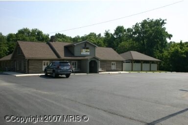
7536 Millstone Rd, Hancock, MD 21750

Property Detail
7536 Millstone Rd
05-001978
2.2 ACRES 7536 MILLSTONE ROAD HANCOCK
Multifamilydwelling
Washington
RB-E
Maryland
B and X Area of moderate flood hazard, usually the area between the limits of the 100-year and 500-year floods.
2.20 AC
2024
Washington County
2025
Washington, DC
010700
Hagerstown-Martinsburg, MD-WV
800 SF
NEARBY LISTINGS FOR SALE OR LEASE
-
-
View all Hancock listings for sale on LoopNet.com
DEMOGRAPHICS near 7536 Millstone Rd
1 mile
3 mile
5 mile
2025 Total Population
199
2,123
6,549
2030 Population
201
2,160
6,673
Pop Growth 2025-2030
+ 1.01%
+ 1.74%
+ 1.89%
Average Age
44
44
44
2025 Total Households
80
871
2,737
HH Growth 2025-2030
+ 1.25%
+ 1.84%
+ 1.94%
Median Household Inc
$77,500
$69,807
$65,875
Avg Household Size
2.50
2.40
2.40
2025 Avg HH Vehicles
3.00
3.00
2.00
Median Home Value
$228,000
$239,655
$245,226
Median Year Built
1980
1982
1979
Nearby Places
Map Layers
Map Styles
 Street
 Aerial
Transit
 Traffic
 Biking
Places
Listings with unknown addresses are not visible on the map
- Restaurants
- Banks
- Shops
- Fitness
- Groceries
PUBLIC TRANSPORTATION
AIRPORT
Hagerstown Regional/Richard A Henson Field
Drive
Walk
Distance
Hagerstown Regional/Richard A Henson Field
36 min
28.6 mi
Nearby Properties
Address
Land Use
TOTAL SIZE
Lot Size
Zoning
Address
Land Use
TOTAL SIZE
Lot Size
Zoning
28,800 SF
52.35 AC
U
Address
Land Use
TOTAL SIZE
Lot Size
Zoning
3,270 SF
18.82 AC
BG
Address
Land Use
TOTAL SIZE
Lot Size
Zoning
58,599 SF
5.25 AC
BG
Address
Land Use
TOTAL SIZE
Lot Size
Zoning
5,794 SF
3.24 AC
EC
Address
Land Use
TOTAL SIZE
Lot Size
Zoning
12,957 SF
0.50 AC
U
Address
Land Use
TOTAL SIZE
Lot Size
Zoning
92.15 AC
U
Address
Land Use
TOTAL SIZE
Lot Size
Zoning
900 SF
1.46 AC
BG
Address
Land Use
TOTAL SIZE
Lot Size
Zoning
12,000 SF
2.50 AC
BG
Address
Land Use
TOTAL SIZE
Lot Size
Zoning
2,844 SF
0.38 AC
U
Address
Land Use
TOTAL SIZE
Lot Size
Zoning
39,500 SF
1.78 AC
GC
Address
Land Use
TOTAL SIZE
Lot Size
Zoning
2,504 SF
0.41 AC
U
Address
Land Use
TOTAL SIZE
Lot Size
Zoning
193.67 AC
EC
Address
Land Use
TOTAL SIZE
Lot Size
Zoning
218.10 AC
U
Address
Land Use
TOTAL SIZE
Lot Size
Zoning
15,392 SF
4.35 AC
BG
Address
Land Use
TOTAL SIZE
Lot Size
Zoning
Address
Land Use
TOTAL SIZE
Lot Size
Zoning
1,314 SF
4.44 AC
EC
Address
Land Use
TOTAL SIZE
Lot Size
Zoning
1,792 SF
41.53 AC
Address
Land Use
TOTAL SIZE
Lot Size
Zoning
4,800 SF
3.03 AC
U
Address
Land Use
TOTAL SIZE
Lot Size
Zoning
3,397 SF
67.07 AC
Address
Land Use
TOTAL SIZE
Lot Size
Zoning
107.52 AC
EC
Address
Land Use
TOTAL SIZE
Lot Size
Zoning
10.98 AC
C
Address
Land Use
TOTAL SIZE
Lot Size
Zoning
6,120 SF
0.93 AC
BG
Address
Land Use
TOTAL SIZE
Lot Size
Zoning
1,916 SF
10.32 AC
Address
Land Use
TOTAL SIZE
Lot Size
Zoning
4,116 SF
134.08 AC
Address
Land Use
TOTAL SIZE
Lot Size
Zoning
4,248 SF
0.31 AC
U
Address
Land Use
TOTAL SIZE
Lot Size
Zoning
6,030 SF
8.32 AC
BG
Address
Land Use
TOTAL SIZE
Lot Size
Zoning
1,956 SF
135 AC
Address
Land Use
TOTAL SIZE
Lot Size
Zoning
1,898 SF
0.49 AC
U
Address
Land Use
TOTAL SIZE
Lot Size
Zoning
0.06 AC
U
The World's #1 Commercial Real Estate Marketplace
Connect with us
© 2026 CoStar Group
The information above has been obtained from sources believed reliable. While we do not doubt its accuracy we have not verified it and make no guarantee, warranty or representation about it. It is your responsibility to independently confirm its accuracy and completeness. Any projections, opinions, assumptions, or estimates used are for example only and do not represent the current or future performance of the property. The value of this transaction to you depends on tax and other factors which should be evaluated by your tax, financial, and legal advisors. You and your advisors should conduct a careful, independent investigation of the property to determine to your satisfaction the suitability of the property for your needs.