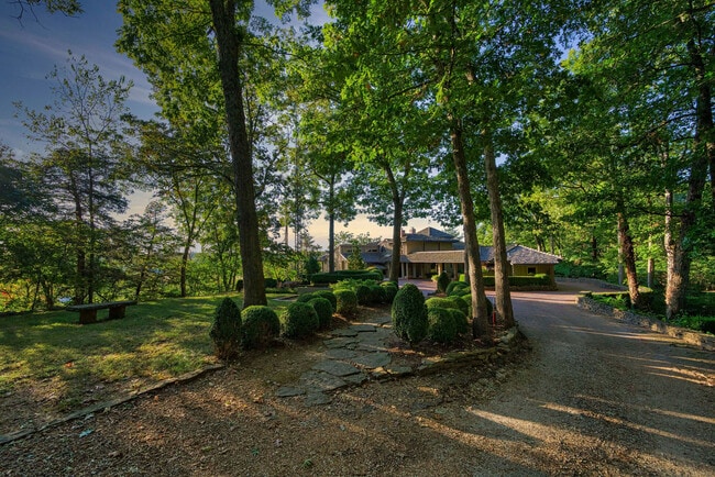
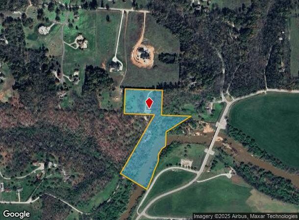
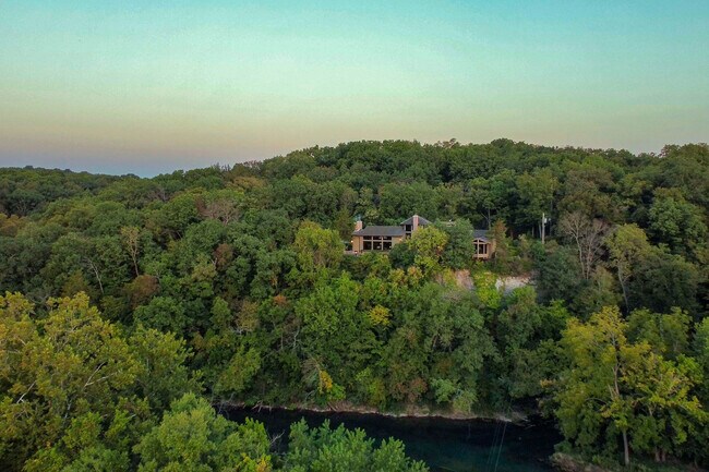
Property Record
754 E Stone Hill Dr, Ozark, MO 65721
NEARBY LISTINGS FOR SALE OR LEASE
Property Detail
754 E Stone Hill Dr
11-0.6-14-000-000-013.001
Ozark Out
Sfr
TR2 PT NE4
AE
Christian
29043C0087D
Missouri
2024
11.30 AC
2025
East Christian County
020304
Springfield
4,276 SF
Springfield, MO
DEMOGRAPHICS near 754 E Stone Hill Dr
1 mile
3 mile
5 mile
2024 Total Population
2,644
26,764
49,683
2029 Population
3,014
30,035
55,627
Pop Growth 2024-2029
+ 13.99%
+ 12.22%
+ 11.96%
Average Age
39
38
39
2024 Total Households
897
9,878
18,518
HH Growth 2024-2029
+ 14.16%
+ 12.32%
+ 12.02%
Median Household Inc
$85,109
$74,291
$77,973
Avg Household Size
2.90
2.60
2.60
2024 Avg HH Vehicles
2.00
2.00
2.00
Median Home Value
$262,553
$214,972
$244,763
Median Year Built
2002
2000
2000
Nearby Places
Map Layers
Map Styles
 Street
 Aerial
Transit
 Traffic
 Biking
Places
Listings with unknown addresses are not visible on the map
- Restaurants
- Banks
- Shops
- Fitness
- Groceries
PUBLIC TRANSPORTATION
AIRPORT
Springfield-Branson Ntl
Drive
Walk
Distance
Springfield-Branson Ntl
48 min
29.3 mi
Freight Ports
Tulsa Port of Inola
Drive
Walk
Distance
Tulsa Port of Inola
212 min
183.8 mi
SALE & LEASE HISTORY
LISTING DATE
SALE/LEASE

Dec 23, 2024
For Sale
Nearby Properties
Address
Land Use
TOTAL SIZE
Lot Size
Zoning
Address
Land Use
TOTAL SIZE
Lot Size
Zoning
2,400 SF
41.33 AC
Address
Land Use
TOTAL SIZE
Lot Size
Zoning
1,632 SF
12 AC
Address
Land Use
TOTAL SIZE
Lot Size
Zoning
13,048 SF
9.29 AC
Address
Land Use
TOTAL SIZE
Lot Size
Zoning
6,000 SF
50.60 AC
Address
Land Use
TOTAL SIZE
Lot Size
Zoning
129,257 SF
32 AC
Address
Land Use
TOTAL SIZE
Lot Size
Zoning
33,019 SF
6.24 AC
Address
Land Use
TOTAL SIZE
Lot Size
Zoning
3,942 SF
40 AC
Address
Land Use
TOTAL SIZE
Lot Size
Zoning
9,474 SF
8.90 AC
Address
Land Use
TOTAL SIZE
Lot Size
Zoning
3,025 SF
2.20 AC
Address
Land Use
TOTAL SIZE
Lot Size
Zoning
968 SF
18.67 AC
Address
Land Use
TOTAL SIZE
Lot Size
Zoning
4,800 SF
10.57 AC
Address
Land Use
TOTAL SIZE
Lot Size
Zoning
2,100 SF
20 AC
Address
Land Use
TOTAL SIZE
Lot Size
Zoning
77,079 SF
28.40 AC
Address
Land Use
TOTAL SIZE
Lot Size
Zoning
48,227 SF
3.07 AC
Address
Land Use
TOTAL SIZE
Lot Size
Zoning
3,910 SF
6.33 AC
Address
Land Use
TOTAL SIZE
Lot Size
Zoning
7,472 SF
4.51 AC
Address
Land Use
TOTAL SIZE
Lot Size
Zoning
53,125 SF
8.01 AC
Address
Land Use
TOTAL SIZE
Lot Size
Zoning
5,184 SF
5.30 AC
Address
Land Use
TOTAL SIZE
Lot Size
Zoning
8,933 SF
8.64 AC
Address
Land Use
TOTAL SIZE
Lot Size
Zoning
38,524 SF
6.54 AC
Address
Land Use
TOTAL SIZE
Lot Size
Zoning
13,634 SF
3.51 AC
Address
Land Use
TOTAL SIZE
Lot Size
Zoning
5,824 SF
6.68 AC
Address
Land Use
TOTAL SIZE
Lot Size
Zoning
41,000 SF
4.50 AC
Address
Land Use
TOTAL SIZE
Lot Size
Zoning
23,625 SF
7.98 AC
Address
Land Use
TOTAL SIZE
Lot Size
Zoning
Address
Land Use
TOTAL SIZE
Lot Size
Zoning
3,003 SF
6.46 AC
Address
Land Use
TOTAL SIZE
Lot Size
Zoning
20,765 SF
3 AC
Address
Land Use
TOTAL SIZE
Lot Size
Zoning
9,285 SF
5.49 AC
Address
Land Use
TOTAL SIZE
Lot Size
Zoning
8,802 SF
5.26 AC
Address
Land Use
TOTAL SIZE
Lot Size
Zoning
5,760 SF
8.62 AC
The World's #1 Commercial Real Estate Marketplace
Connect with us
© 2026 CoStar Group
The information above has been obtained from sources believed reliable. While we do not doubt its accuracy we have not verified it and make no guarantee, warranty or representation about it. It is your responsibility to independently confirm its accuracy and completeness. Any projections, opinions, assumptions, or estimates used are for example only and do not represent the current or future performance of the property. The value of this transaction to you depends on tax and other factors which should be evaluated by your tax, financial, and legal advisors. You and your advisors should conduct a careful, independent investigation of the property to determine to your satisfaction the suitability of the property for your needs.