Property Record
752 N Main St, Oshkosh, WI 54901
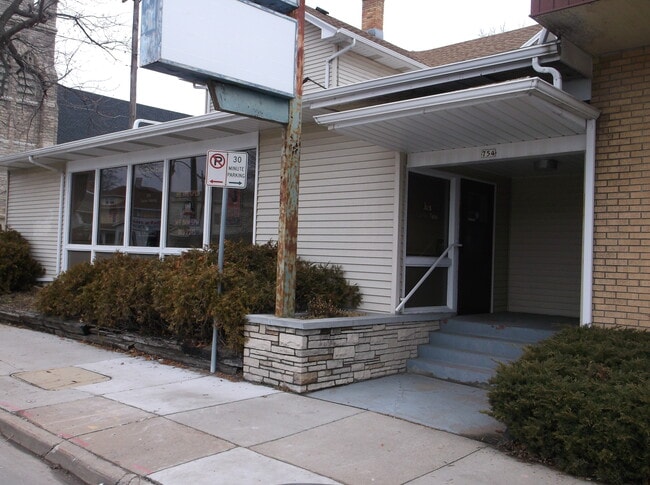
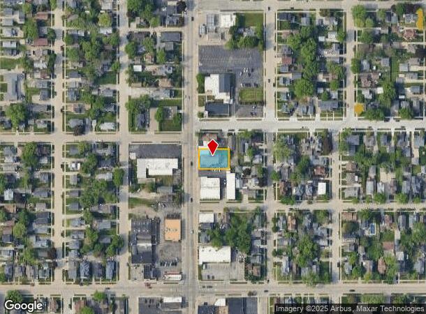
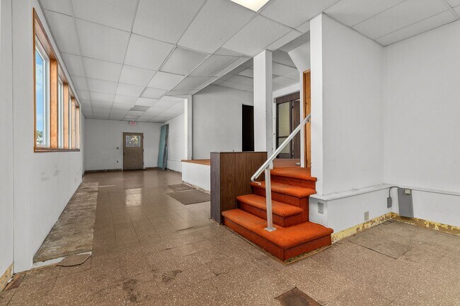
This Property Is For Sale
NEARBY LISTINGS FOR SALE OR LEASE
Property Detail
752 N Main St
Oshkosh-Neenah, WI
Baldwin & Knapps Addition
10-00520000
W 120 FT OF LOT 3 & S 12.1 FT OF W 120 FT OF LOT 4 BLK BBALDWIN & KNAPPS ADDN
Industrialgeneral
Winnebago
X
Wisconsin
55139C0220E
3,4
2024
0.22 AC
2024
Downtown Oshkosh
000502
Other Market Areas
4,106 SF
DEMOGRAPHICS near 752 N Main St
1 Mile
3 Mile
5 Mile
2024 Total Population
18,476
57,073
75,556
2029 Population
18,523
57,350
75,859
Pop Growth 2024-2029
+ 0.25%
+ 0.49%
+ 0.40%
Average Age
34
39
39
2024 Total Households
7,444
24,399
31,410
HH Growth 2024-2029
+ 0.46%
+ 0.69%
+ 0.62%
Median Household Inc
$50,956
$53,891
$59,149
Avg Household Size
2.10
2.10
2.20
2024 Avg HH Vehicles
2.00
2.00
2.00
Median Home Value
$129,569
$152,844
$171,069
Median Year Built
1948
1965
1972
Nearby Places
- Restaurants
- Banks
- Shops
- Fitness
- Groceries
PUBLIC TRANSPORTATION
AIRPORT
Appleton International
DRIVE
WALK
Distance
Appleton International
29 min
20.2 mi
Green Bay/Austin Straubel International
DRIVE
WALK
Distance
Green Bay/Austin Straubel International
60 min
48.0 mi
Nearby Properties
Address
Land Use
TOTAL SIZE
Lot Size
Zoning
Address
Land Use
TOTAL SIZE
Lot Size
Zoning
32.81 AC
CBPPD
Address
Land Use
TOTAL SIZE
Lot Size
Zoning
7.74 AC
Address
Land Use
TOTAL SIZE
Lot Size
Zoning
195,810 SF
31.08 AC
MR-20
Address
Land Use
TOTAL SIZE
Lot Size
Zoning
208,278 SF
22.77 AC
C2
Address
Land Use
TOTAL SIZE
Lot Size
Zoning
255,080 SF
21.29 AC
MR-12
Address
Land Use
TOTAL SIZE
Lot Size
Zoning
570,585 SF
81.26 AC
M2
Address
Land Use
TOTAL SIZE
Lot Size
Zoning
552,602 SF
7.28 AC
M3
Address
Land Use
TOTAL SIZE
Lot Size
Zoning
128,951 SF
4.95 AC
R1
Address
Land Use
TOTAL SIZE
Lot Size
Zoning
485,007 SF
41.76 AC
M3
Address
Land Use
TOTAL SIZE
Lot Size
Zoning
195,847 SF
4.66 AC
UMU-PD
Address
Land Use
TOTAL SIZE
Lot Size
Zoning
14.77 AC
SMU-PD
Address
Land Use
TOTAL SIZE
Lot Size
Zoning
2.29 AC
RMUPDRFO
Address
Land Use
TOTAL SIZE
Lot Size
Zoning
70,672 SF
4.97 AC
Address
Land Use
TOTAL SIZE
Lot Size
Zoning
161,640 SF
18.54 AC
C-2PD
Address
Land Use
TOTAL SIZE
Lot Size
Zoning
70,335 SF
16 AC
HI
Address
Land Use
TOTAL SIZE
Lot Size
Zoning
2.63 AC
RMU-PD-RFO
Address
Land Use
TOTAL SIZE
Lot Size
Zoning
2.40 AC
CBP-PD
Address
Land Use
TOTAL SIZE
Lot Size
Zoning
152,505 SF
6.54 AC
MR-20-RFO
Address
Land Use
TOTAL SIZE
Lot Size
Zoning
136,368 SF
10.24 AC
C-2PD
Address
Land Use
TOTAL SIZE
Lot Size
Zoning
84,363 SF
10.97 AC
C-2PD
Address
Land Use
TOTAL SIZE
Lot Size
Zoning
53,998 SF
3.63 AC
C2
Address
Land Use
TOTAL SIZE
Lot Size
Zoning
175,906 SF
11.60 AC
MR-20
Address
Land Use
TOTAL SIZE
Lot Size
Zoning
1.78 AC
C3
Address
Land Use
TOTAL SIZE
Lot Size
Zoning
107,778 SF
8.57 AC
SMUPD
Address
Land Use
TOTAL SIZE
Lot Size
Zoning
25,456 SF
1.74 AC
R1;SINGLE
Address
Land Use
TOTAL SIZE
Lot Size
Zoning
9.86 AC
MR-12
Address
Land Use
TOTAL SIZE
Lot Size
Zoning
92,958 SF
1.02 AC
C2
Address
Land Use
TOTAL SIZE
Lot Size
Zoning
128,951 SF
1.15 AC
R1;SINGLE
Address
Land Use
TOTAL SIZE
Lot Size
Zoning
80,118 SF
7.88 AC
C2
Address
Land Use
TOTAL SIZE
Lot Size
Zoning
34,340 SF
8.56 AC
C2
The World's #1 Commercial Real Estate Marketplace
Connect with us
© 2025 CoStar Group
The information above has been obtained from sources believed reliable. While we do not doubt its accuracy we have not verified it and make no guarantee, warranty or representation about it. It is your responsibility to independently confirm its accuracy and completeness. Any projections, opinions, assumptions, or estimates used are for example only and do not represent the current or future performance of the property. The value of this transaction to you depends on tax and other factors which should be evaluated by your tax, financial, and legal advisors. You and your advisors should conduct a careful, independent investigation of the property to determine to your satisfaction the suitability of the property for your needs.