Property Record
7540 Highway 97, Mc David, FL 32568
This Property Is For Sale
NEARBY LISTINGS FOR SALE OR LEASE
-
-
View all Mc David listings for sale on LoopNet.com
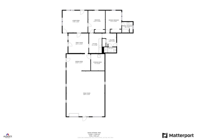
Property Detail
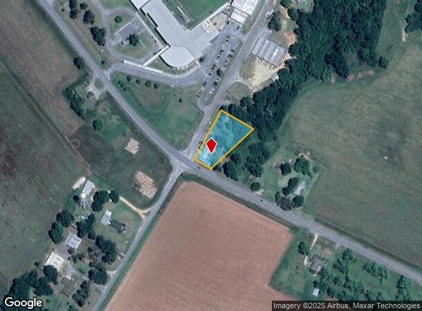
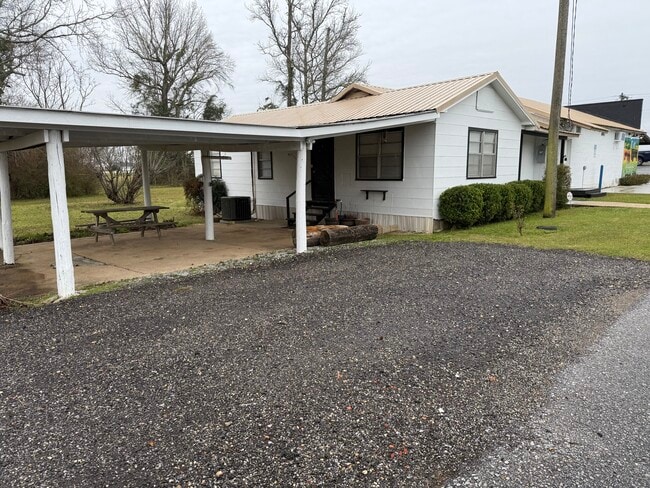
7540 Highway 97
38-4N-32-1001-000-001
Subdivision Number: 1001
Storesoffices
BEG AT INTER OF ELY LI OF MCDAVID RD AND NLY LI OF ATMORE MOLINO H/W NLY ALG MCDAVID RD 270 FT ELY AT RT ANG 180 FT TO GULLY SLY ALG GULLY TO H/W WLY ALG H/W 93 FT TO POB OR 8525 P 1549 LESS OR 412 P 819 STATE RD 99-A R/W
X
Escambia
12033C0040G
Florida
2023
0.75 AC
2024
Upper Escambia County
003900
Pensacola
2,500 SF
Pensacola-Ferry Pass-Brent, FL
DEMOGRAPHICS near 7540 Highway 97
1 Mile
3 Mile
5 Mile
2024 Total Population
78
857
1,590
2029 Population
76
845
1,566
Pop Growth 2024-2029
(2.56%)
(1.40%)
(1.51%)
Average Age
42
42
42
2024 Total Households
30
336
628
HH Growth 2024-2029
0.00%
(1.19%)
(1.43%)
Median Household Inc
$48,749
$49,755
$50,192
Avg Household Size
2.50
2.50
2.50
2024 Avg HH Vehicles
2.00
2.00
2.00
Median Home Value
$145,000
$148,571
$154,999
Median Year Built
1984
1985
1985
Nearby Places
- Restaurants
- Banks
- Shops
- Fitness
- Groceries
Nearby Properties
Address
Land Use
TOTAL SIZE
Lot Size
Zoning
Address
Land Use
TOTAL SIZE
Lot Size
Zoning
122,481 SF
41.44 AC
PUB
Address
Land Use
TOTAL SIZE
Lot Size
Zoning
28,359 SF
22.51 AC
RR
Address
Land Use
TOTAL SIZE
Lot Size
Zoning
5,720 SF
54.01 AC
AGR
Address
Land Use
TOTAL SIZE
Lot Size
Zoning
6,881 SF
58.66 AC
AGR
Address
Land Use
TOTAL SIZE
Lot Size
Zoning
5,732 SF
54.86 AC
AGR
Address
Land Use
TOTAL SIZE
Lot Size
Zoning
10,857 SF
4.12 AC
RMU
Address
Land Use
TOTAL SIZE
Lot Size
Zoning
26,232 SF
38.91 AC
AGR
Address
Land Use
TOTAL SIZE
Lot Size
Zoning
6,225 SF
90.02 AC
AGR
Address
Land Use
TOTAL SIZE
Lot Size
Zoning
8,311 SF
1.01 AC
AGR
Address
Land Use
TOTAL SIZE
Lot Size
Zoning
2,692 SF
27.03 AC
RR
Address
Land Use
TOTAL SIZE
Lot Size
Zoning
14,309 SF
3.70 AC
AGR
Address
Land Use
TOTAL SIZE
Lot Size
Zoning
3,740 SF
2.05 AC
RR
Address
Land Use
TOTAL SIZE
Lot Size
Zoning
6,864 SF
10.17 AC
AGR
Address
Land Use
TOTAL SIZE
Lot Size
Zoning
8,975 SF
14.90 AC
RMU
Address
Land Use
TOTAL SIZE
Lot Size
Zoning
2,616 SF
18.63 AC
IND
Address
Land Use
TOTAL SIZE
Lot Size
Zoning
3,620 SF
238.13 AC
AGR
Address
Land Use
TOTAL SIZE
Lot Size
Zoning
6,480 SF
2.28 AC
AGR
Address
Land Use
TOTAL SIZE
Lot Size
Zoning
2,836 SF
4.40 AC
RR
Address
Land Use
TOTAL SIZE
Lot Size
Zoning
11,911 SF
4.20 AC
AGR
Address
Land Use
TOTAL SIZE
Lot Size
Zoning
6,484 SF
4.61 AC
AGR,RR
Address
Land Use
TOTAL SIZE
Lot Size
Zoning
2,402 SF
29 AC
AGR
Address
Land Use
TOTAL SIZE
Lot Size
Zoning
2,850 SF
18.01 AC
AGR
Address
Land Use
TOTAL SIZE
Lot Size
Zoning
7,244 SF
51.70 AC
AGR
Address
Land Use
TOTAL SIZE
Lot Size
Zoning
2,124 SF
0.51 AC
RMU
Address
Land Use
TOTAL SIZE
Lot Size
Zoning
2,631 SF
197 AC
AGR
Address
Land Use
TOTAL SIZE
Lot Size
Zoning
2,666 SF
20 AC
AGR
Address
Land Use
TOTAL SIZE
Lot Size
Zoning
1,618 SF
144.01 AC
AGR
Address
Land Use
TOTAL SIZE
Lot Size
Zoning
2,447 SF
35.72 AC
AGR
Address
Land Use
TOTAL SIZE
Lot Size
Zoning
3,819 SF
2.25 AC
AGR
Address
Land Use
TOTAL SIZE
Lot Size
Zoning
9,856 SF
1.50 AC
RMU
The World's #1 Commercial Real Estate Marketplace
Connect with us
© 2025 CoStar Group
The information above has been obtained from sources believed reliable. While we do not doubt its accuracy we have not verified it and make no guarantee, warranty or representation about it. It is your responsibility to independently confirm its accuracy and completeness. Any projections, opinions, assumptions, or estimates used are for example only and do not represent the current or future performance of the property. The value of this transaction to you depends on tax and other factors which should be evaluated by your tax, financial, and legal advisors. You and your advisors should conduct a careful, independent investigation of the property to determine to your satisfaction the suitability of the property for your needs.