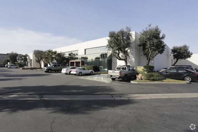
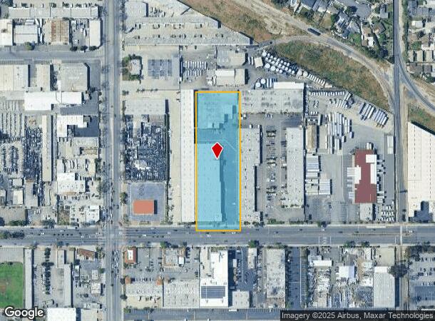
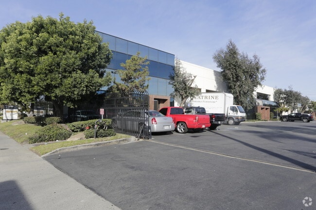
Property Record
7541 Rosecrans Ave, Paramount, CA 90723

Current Lease Availabilities
NEARBY LISTINGS FOR SALE OR LEASE
Property Detail
7541 Rosecrans Ave
Los Angeles-Long Beach-Glendale, CA
California Cooperative Colony Tract
6242-020-049
M R 21-15-16 W 200 FT OF E 945 FT OF LOTS 9 AND 10 BLK 3
Warehouse
Los Angeles
X
California
06037C1820F
9,10
2024
2.89 AC
2025
Downey/Paramount
553601
Los Angeles
117,260 SF
DEMOGRAPHICS near 7541 Rosecrans Ave
1 mile
3 mile
5 mile
2024 Total Population
31,867
316,237
797,944
2029 Population
30,702
304,436
765,830
Pop Growth 2024-2029
(3.66%)
(3.73%)
(4.02%)
Average Age
35
37
37
2024 Total Households
8,162
85,127
220,038
HH Growth 2024-2029
(3.93%)
(3.93%)
(4.24%)
Median Household Inc
$62,801
$67,418
$68,667
Avg Household Size
3.80
3.60
3.50
2024 Avg HH Vehicles
2.00
2.00
2.00
Median Home Value
$500,306
$573,314
$620,441
Median Year Built
1966
1959
1957
Nearby Places
Map Layers
Map Styles
 Street
 Aerial
Transit
 Traffic
 Biking
Places
Listings with unknown addresses are not visible on the map
- Restaurants
- Banks
- Shops
- Fitness
- Groceries
PUBLIC TRANSPORTATION
COMMUTER RAIL
Commerce (91 Line - Southern California Regional Rail Authority (Metrolink), Orange County Line - Southern California Regional Rail Authority (Metrolink))
Drive
Walk
Distance
Commerce (91 Line - Southern California Regional Rail Authority (Metrolink), Orange County Line - Southern California Regional Rail Authority (Metrolink))
15 min
7.0 mi
Norwalk/Santa Fe Springs (91 Line - Southern California Regional Rail Authority (Metrolink), Orange County Line - Southern California Regional Rail Authority (Metrolink))
Drive
Walk
Distance
Norwalk/Santa Fe Springs (91 Line - Southern California Regional Rail Authority (Metrolink), Orange County Line - Southern California Regional Rail Authority (Metrolink))
12 min
7.1 mi
AIRPORT
Long Beach (Daugherty Field)
Drive
Walk
Distance
Long Beach (Daugherty Field)
13 min
6.6 mi
Los Angeles International
Drive
Walk
Distance
Los Angeles International
22 min
16.2 mi
Bob Hope
Drive
Walk
Distance
Bob Hope
40 min
29.7 mi
Freight Ports
Port of Long Beach
Drive
Walk
Distance
Port of Long Beach
18 min
12.1 mi
Nearby Properties
Address
Land Use
TOTAL SIZE
Lot Size
Zoning
Address
Land Use
TOTAL SIZE
Lot Size
Zoning
1,339,758 SF
28.53 AC
DOM2-P*
Address
Land Use
TOTAL SIZE
Lot Size
Zoning
587,291 SF
11.42 AC
LYHMD*
Address
Land Use
TOTAL SIZE
Lot Size
Zoning
313,224 SF
4.41 AC
SGM2*
Address
Land Use
TOTAL SIZE
Lot Size
Zoning
556,348 SF
26.38 AC
PAM2
Address
Land Use
TOTAL SIZE
Lot Size
Zoning
730,731 SF
14.89 AC
BFCG*
Address
Land Use
TOTAL SIZE
Lot Size
Zoning
373,498 SF
5.20 AC
LBR4R
Address
Land Use
TOTAL SIZE
Lot Size
Zoning
395,436 SF
17.22 AC
LBMG
Address
Land Use
TOTAL SIZE
Lot Size
Zoning
332,504 SF
7.76 AC
DOHM
Address
Land Use
TOTAL SIZE
Lot Size
Zoning
105,586 SF
9.96 AC
SGM3*
Address
Land Use
TOTAL SIZE
Lot Size
Zoning
106,028 SF
6.42 AC
DOM2-P*
Address
Land Use
TOTAL SIZE
Lot Size
Zoning
99,674 SF
6.53 AC
DOM2-P*
Address
Land Use
TOTAL SIZE
Lot Size
Zoning
155,384 SF
11.59 AC
DOM2-P*
Address
Land Use
TOTAL SIZE
Lot Size
Zoning
183,128 SF
10.77 AC
PAM2*
Address
Land Use
TOTAL SIZE
Lot Size
Zoning
111,746 SF
4.38 AC
DOM2-P*
Address
Land Use
TOTAL SIZE
Lot Size
Zoning
439,058 SF
8.57 AC
DOM2*
Address
Land Use
TOTAL SIZE
Lot Size
Zoning
149,723 SF
9.90 AC
LBIG
Address
Land Use
TOTAL SIZE
Lot Size
Zoning
77,168 SF
2.90 AC
DOR3-P*
Address
Land Use
TOTAL SIZE
Lot Size
Zoning
126,905 SF
7.87 AC
LBCHW
Address
Land Use
TOTAL SIZE
Lot Size
Zoning
105,229 SF
2.08 AC
PACM*
Address
Land Use
TOTAL SIZE
Lot Size
Zoning
150,185 SF
2.78 AC
BFM1-CG*
Address
Land Use
TOTAL SIZE
Lot Size
Zoning
109,117 SF
6.58 AC
DOM2-P*
Address
Land Use
TOTAL SIZE
Lot Size
Zoning
380,681 SF
8.84 AC
BFM1*
Address
Land Use
TOTAL SIZE
Lot Size
Zoning
51,593 SF
3.92 AC
LYM*
Address
Land Use
TOTAL SIZE
Lot Size
Zoning
45,726 SF
1.56 AC
BFCG-R3-R1
Address
Land Use
TOTAL SIZE
Lot Size
Zoning
114,768 SF
18.82 AC
LBIG
Address
Land Use
TOTAL SIZE
Lot Size
Zoning
141,567 SF
10.12 AC
PAM1*
Address
Land Use
TOTAL SIZE
Lot Size
Zoning
100,648 SF
0.85 AC
PAM2*
Address
Land Use
TOTAL SIZE
Lot Size
Zoning
82,334 SF
4.31 AC
SGM3*
The World's #1 Commercial Real Estate Marketplace
Connect with us
© 2026 CoStar Group
The information above has been obtained from sources believed reliable. While we do not doubt its accuracy we have not verified it and make no guarantee, warranty or representation about it. It is your responsibility to independently confirm its accuracy and completeness. Any projections, opinions, assumptions, or estimates used are for example only and do not represent the current or future performance of the property. The value of this transaction to you depends on tax and other factors which should be evaluated by your tax, financial, and legal advisors. You and your advisors should conduct a careful, independent investigation of the property to determine to your satisfaction the suitability of the property for your needs.