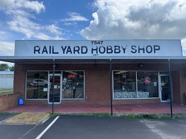
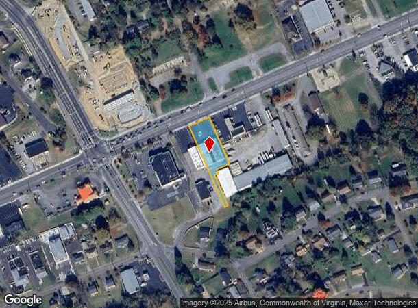
Property Record
7545 Williamson Rd, Roanoke, VA 24019
NEARBY LISTINGS FOR SALE OR LEASE
Property Detail
7545 Williamson Rd
027.11-03-07.01-0000
Rt 11 Commercial Hollins
Commercialnec
PT TR A BLK 1 SUMMERDEAN MAP 1
X
Roanoke
51023C0455C
Virginia
2025
0.60 AC
2025
Northeast Roanoke
030203
Roanoke
10,201 SF
Roanoke, VA
DEMOGRAPHICS near 7545 Williamson Rd
1 mile
3 mile
5 mile
2024 Total Population
5,386
30,578
80,507
2029 Population
5,441
30,554
80,392
Pop Growth 2024-2029
+ 1.02%
(0.08%)
(0.14%)
Average Age
41
42
41
2024 Total Households
2,075
12,596
33,333
HH Growth 2024-2029
+ 1.06%
(0.13%)
(0.19%)
Median Household Inc
$71,634
$67,671
$59,837
Avg Household Size
2.30
2.30
2.30
2024 Avg HH Vehicles
2.00
2.00
2.00
Median Home Value
$256,065
$244,561
$234,111
Median Year Built
1971
1972
1971
Nearby Places
Map Layers
Map Styles
 Street
 Aerial
Transit
 Traffic
 Biking
Places
Listings with unknown addresses are not visible on the map
- Restaurants
- Banks
- Shops
- Fitness
- Groceries
PUBLIC TRANSPORTATION
COMMUTER RAIL
Drive
Walk
Distance
16 min
8.7 mi
AIRPORT
Roanoke/Blacksburg Regional (Woodrum Field)
Drive
Walk
Distance
Roanoke/Blacksburg Regional (Woodrum Field)
10 min
3.0 mi
SALE & LEASE HISTORY
LISTING DATE
SALE/LEASE

Aug 19, 2025
For Lease
Nearby Properties
Address
Land Use
TOTAL SIZE
Lot Size
Zoning
Address
Land Use
TOTAL SIZE
Lot Size
Zoning
8,930 SF
604.76 AC
AD
Address
Land Use
TOTAL SIZE
Lot Size
Zoning
3,678 SF
223.62 AC
C1
Address
Land Use
TOTAL SIZE
Lot Size
Zoning
5,957.14 AC
FC
Address
Land Use
TOTAL SIZE
Lot Size
Zoning
67,903 SF
11.96 AC
I2
Address
Land Use
TOTAL SIZE
Lot Size
Zoning
609,211 SF
41.01 AC
I1C
Address
Land Use
TOTAL SIZE
Lot Size
Zoning
40.04 AC
M-2
Address
Land Use
TOTAL SIZE
Lot Size
Zoning
15,312 SF
182.27 AC
AG3
Address
Land Use
TOTAL SIZE
Lot Size
Zoning
10,878 SF
10.34 AC
RMF
Address
Land Use
TOTAL SIZE
Lot Size
Zoning
207,812 SF
22.62 AC
CLS
Address
Land Use
TOTAL SIZE
Lot Size
Zoning
22.52 AC
R-1
Address
Land Use
TOTAL SIZE
Lot Size
Zoning
71,590 SF
2.49 AC
CLS
Address
Land Use
TOTAL SIZE
Lot Size
Zoning
124,725 SF
6.53 AC
I1
Address
Land Use
TOTAL SIZE
Lot Size
Zoning
48,935 SF
9.15 AC
RMF
Address
Land Use
TOTAL SIZE
Lot Size
Zoning
139,654 SF
4.77 AC
C2S
Address
Land Use
TOTAL SIZE
Lot Size
Zoning
1.86 AC
CLS
Address
Land Use
TOTAL SIZE
Lot Size
Zoning
22,950 SF
9.50 AC
R3
Address
Land Use
TOTAL SIZE
Lot Size
Zoning
198,089 SF
46.65 AC
AD
Address
Land Use
TOTAL SIZE
Lot Size
Zoning
162,236 SF
13.71 AC
CLS
Address
Land Use
TOTAL SIZE
Lot Size
Zoning
90,571 SF
10.34 AC
INPUD
Address
Land Use
TOTAL SIZE
Lot Size
Zoning
130,957 SF
15.12 AC
CLS
Address
Land Use
TOTAL SIZE
Lot Size
Zoning
135,212 SF
11.29 AC
CLS
Address
Land Use
TOTAL SIZE
Lot Size
Zoning
112,165 SF
9.27 AC
CLS
Address
Land Use
TOTAL SIZE
Lot Size
Zoning
47,510 SF
7.67 AC
CLS
Address
Land Use
TOTAL SIZE
Lot Size
Zoning
70,091 SF
11.82 AC
R1
Address
Land Use
TOTAL SIZE
Lot Size
Zoning
35,582 SF
16.36 AC
I2S
Address
Land Use
TOTAL SIZE
Lot Size
Zoning
5,433 SF
20.63 AC
AD
Address
Land Use
TOTAL SIZE
Lot Size
Zoning
70,770 SF
6 AC
R3
Address
Land Use
TOTAL SIZE
Lot Size
Zoning
88,570 SF
10.02 AC
CLS
Address
Land Use
TOTAL SIZE
Lot Size
Zoning
24,512 SF
9.10 AC
C2S
Address
Land Use
TOTAL SIZE
Lot Size
Zoning
92,239 SF
11.41 AC
CLS
The World's #1 Commercial Real Estate Marketplace
Connect with us
© 2026 CoStar Group
The information above has been obtained from sources believed reliable. While we do not doubt its accuracy we have not verified it and make no guarantee, warranty or representation about it. It is your responsibility to independently confirm its accuracy and completeness. Any projections, opinions, assumptions, or estimates used are for example only and do not represent the current or future performance of the property. The value of this transaction to you depends on tax and other factors which should be evaluated by your tax, financial, and legal advisors. You and your advisors should conduct a careful, independent investigation of the property to determine to your satisfaction the suitability of the property for your needs.