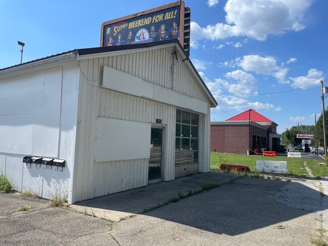
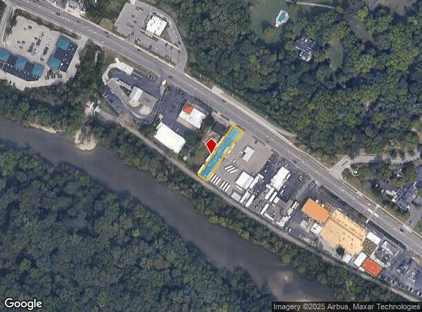
Property Record
7547 Wooster Pike, Cincinnati, OH 45227
Current Lease Availabilities
NEARBY LISTINGS FOR SALE OR LEASE
Property Detail
7547 Wooster Pike
Cincinnati, OH-KY-IN
Henry Debolts Sub
520-0112-0071
SS WOOSTER PK REAR 30 X FT IRR PTS LOTS 2-3 HENRY DEBOLTS SUB PARS 71-72 CONS
Storebuilding
Hamilton
AE
Ohio
39061C0263F
2-3
2025
0.21 AC
2025
Fairfax/Mt. Lookout
005600
Cincinnati/Dayton
1,036 SF
DEMOGRAPHICS near 7547 Wooster Pike
1 Mile
3 Mile
5 Mile
2024 Total Population
2,785
35,951
159,322
2029 Population
2,830
36,341
160,681
Pop Growth 2024-2029
+ 1.62%
+ 1.08%
+ 0.85%
Average Age
42
41
40
2024 Total Households
1,067
14,708
69,785
HH Growth 2024-2029
+ 1.78%
+ 1.25%
+ 0.94%
Median Household Inc
$127,045
$100,696
$90,325
Avg Household Size
2.50
2.40
2.20
2024 Avg HH Vehicles
2.00
2.00
2.00
Median Home Value
$663,651
$427,949
$343,947
Median Year Built
1955
1959
1960
Nearby Places
Map Layers
Map Styles
 Street
 Aerial
- Restaurants
- Banks
- Shops
- Fitness
- Groceries
PUBLIC TRANSPORTATION
AIRPORT
Cincinnati/Northern Kentucky International
DRIVE
WALK
Distance
Cincinnati/Northern Kentucky International
45 min
24.7 mi
Nearby Properties
Address
Land Use
TOTAL SIZE
Lot Size
Zoning
Address
Land Use
TOTAL SIZE
Lot Size
Zoning
9.16 AC
Address
Land Use
TOTAL SIZE
Lot Size
Zoning
5.07 AC
Address
Land Use
TOTAL SIZE
Lot Size
Zoning
0.26 AC
RM12
Address
Land Use
TOTAL SIZE
Lot Size
Zoning
6.91 AC
Address
Land Use
TOTAL SIZE
Lot Size
Zoning
4.57 AC
Address
Land Use
TOTAL SIZE
Lot Size
Zoning
4,706 SF
18.29 AC
RM20
Address
Land Use
TOTAL SIZE
Lot Size
Zoning
7.06 AC
Address
Land Use
TOTAL SIZE
Lot Size
Zoning
6.80 AC
Address
Land Use
TOTAL SIZE
Lot Size
Zoning
20.01 AC
Address
Land Use
TOTAL SIZE
Lot Size
Zoning
1,205 SF
41.47 AC
Address
Land Use
TOTAL SIZE
Lot Size
Zoning
25.51 AC
Address
Land Use
TOTAL SIZE
Lot Size
Zoning
1.77 AC
Address
Land Use
TOTAL SIZE
Lot Size
Zoning
20.38 AC
Address
Land Use
TOTAL SIZE
Lot Size
Zoning
49.27 AC
Address
Land Use
TOTAL SIZE
Lot Size
Zoning
8.99 AC
Address
Land Use
TOTAL SIZE
Lot Size
Zoning
1,134,029 SF
229.73 AC
Address
Land Use
TOTAL SIZE
Lot Size
Zoning
7.49 AC
Address
Land Use
TOTAL SIZE
Lot Size
Zoning
1.90 AC
Address
Land Use
TOTAL SIZE
Lot Size
Zoning
1.94 AC
Address
Land Use
TOTAL SIZE
Lot Size
Zoning
28.27 AC
Address
Land Use
TOTAL SIZE
Lot Size
Zoning
8.64 AC
Address
Land Use
TOTAL SIZE
Lot Size
Zoning
6.55 AC
Address
Land Use
TOTAL SIZE
Lot Size
Zoning
55,848 SF
12.51 AC
Address
Land Use
TOTAL SIZE
Lot Size
Zoning
3,508 SF
9.10 AC
RM12
Address
Land Use
TOTAL SIZE
Lot Size
Zoning
16.40 AC
Address
Land Use
TOTAL SIZE
Lot Size
Zoning
49.66 AC
Address
Land Use
TOTAL SIZE
Lot Size
Zoning
95,592 SF
18 AC
SF10
Address
Land Use
TOTAL SIZE
Lot Size
Zoning
0.19 AC
RM20
Address
Land Use
TOTAL SIZE
Lot Size
Zoning
1.60 AC
Address
Land Use
TOTAL SIZE
Lot Size
Zoning
5.58 AC
RM20
The World's #1 Commercial Real Estate Marketplace
Connect with us
© 2026 CoStar Group
The information above has been obtained from sources believed reliable. While we do not doubt its accuracy we have not verified it and make no guarantee, warranty or representation about it. It is your responsibility to independently confirm its accuracy and completeness. Any projections, opinions, assumptions, or estimates used are for example only and do not represent the current or future performance of the property. The value of this transaction to you depends on tax and other factors which should be evaluated by your tax, financial, and legal advisors. You and your advisors should conduct a careful, independent investigation of the property to determine to your satisfaction the suitability of the property for your needs.