Property Record
755 4Th St, Vero Beach, FL 32962
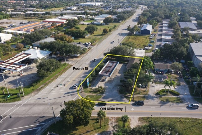


This Property Is For Sale
NEARBY LISTINGS FOR SALE OR LEASE
Property Detail
755 4Th St
33-39-13-00000-7000-00015.0
Null
Supermarket
SEC 13 TWN 33 RNG 39 BEING THE N 104.5 FT OF THE NW QTR OF THE SE QTR OF SEC 13 LYING E OF OLD DIXIE HIGHWAY LESS AND EXCEPT THE E 782 FT THEREOF AND LESS AND EXCEPT THE ROW GIVEN TO INDIAN RIVER COUNTY OR 783/2638 AND OR 1190/578
X
Indian River
12061C0357J
Florida
2025
0.33 AC
2025
Fort Pierce/Port St Lucie
050603
Other Market Areas
1,364 SF
Sebastian-Vero Beach, FL
DEMOGRAPHICS near 755 4Th St
1 Mile
3 Mile
5 Mile
2024 Total Population
9,545
54,400
94,728
2029 Population
10,744
60,816
106,939
Pop Growth 2024-2029
+ 12.56%
+ 11.79%
+ 12.89%
Average Age
50
47
49
2024 Total Households
4,673
24,443
42,000
HH Growth 2024-2029
+ 12.63%
+ 11.65%
+ 12.69%
Median Household Inc
$53,124
$55,154
$58,865
Avg Household Size
2.00
2.10
2.20
2024 Avg HH Vehicles
1.00
2.00
2.00
Median Home Value
$179,780
$233,459
$264,261
Median Year Built
1985
1983
1986
Nearby Places
Map Layers
Map Styles
 Street
 Aerial
- Restaurants
- Banks
- Shops
- Fitness
- Groceries
Nearby Properties
Address
Land Use
TOTAL SIZE
Lot Size
Zoning
Address
Land Use
TOTAL SIZE
Lot Size
Zoning
303,447 SF
26.90 AC
M
Address
Land Use
TOTAL SIZE
Lot Size
Zoning
302,878 SF
40 AC
INST
Address
Land Use
TOTAL SIZE
Lot Size
Zoning
39,873 SF
7.61 AC
GU
Address
Land Use
TOTAL SIZE
Lot Size
Zoning
10,600 SF
36.80 AC
RS-6
Address
Land Use
TOTAL SIZE
Lot Size
Zoning
12,192 SF
40 AC
RS-6
Address
Land Use
TOTAL SIZE
Lot Size
Zoning
125,677 SF
2.17 AC
DTW
Address
Land Use
TOTAL SIZE
Lot Size
Zoning
2,518 SF
3.16 AC
P-2
Address
Land Use
TOTAL SIZE
Lot Size
Zoning
313,820 SF
21.83 AC
RM-10 EX
Address
Land Use
TOTAL SIZE
Lot Size
Zoning
149,178 SF
10.72 AC
C-1B
Address
Land Use
TOTAL SIZE
Lot Size
Zoning
231,651 SF
16.23 AC
RM-10
Address
Land Use
TOTAL SIZE
Lot Size
Zoning
2,888 SF
95.84 AC
R-1AA
Address
Land Use
TOTAL SIZE
Lot Size
Zoning
165,453 SF
29.42 AC
RM-6
Address
Land Use
TOTAL SIZE
Lot Size
Zoning
2,232 SF
8.35 AC
C-1B
Address
Land Use
TOTAL SIZE
Lot Size
Zoning
150,160 SF
13.12 AC
PD
Address
Land Use
TOTAL SIZE
Lot Size
Zoning
5,268 SF
4.62 AC
R-1
Address
Land Use
TOTAL SIZE
Lot Size
Zoning
168,782 SF
17.84 AC
CG
Address
Land Use
TOTAL SIZE
Lot Size
Zoning
2,418 SF
9.77 AC
C-2M
Address
Land Use
TOTAL SIZE
Lot Size
Zoning
9,312 SF
73.67 AC
RS-6
Address
Land Use
TOTAL SIZE
Lot Size
Zoning
9,215 SF
4.58 AC
RM-10/12
Address
Land Use
TOTAL SIZE
Lot Size
Zoning
85,023 SF
16.44 AC
CG
Address
Land Use
TOTAL SIZE
Lot Size
Zoning
7,517 SF
2.50 AC
R-1AA
Address
Land Use
TOTAL SIZE
Lot Size
Zoning
169,566 SF
12.93 AC
RM-8
Address
Land Use
TOTAL SIZE
Lot Size
Zoning
7,590 SF
8.62 AC
R-1A
Address
Land Use
TOTAL SIZE
Lot Size
Zoning
135,072 SF
11.34 AC
CG
Address
Land Use
TOTAL SIZE
Lot Size
Zoning
2,064 SF
21.45 AC
CL
Address
Land Use
TOTAL SIZE
Lot Size
Zoning
8,352 SF
6.34 AC
C-1B
Address
Land Use
TOTAL SIZE
Lot Size
Zoning
5,086 SF
19.65 AC
RS-6
Address
Land Use
TOTAL SIZE
Lot Size
Zoning
28,170 SF
1.41 AC
C-1B
Address
Land Use
TOTAL SIZE
Lot Size
Zoning
2,940 SF
1.45 AC
P-2
Address
Land Use
TOTAL SIZE
Lot Size
Zoning
83,804 SF
7.94 AC
C-1B
The World's #1 Commercial Real Estate Marketplace
Connect with us
© 2026 CoStar Group
The information above has been obtained from sources believed reliable. While we do not doubt its accuracy we have not verified it and make no guarantee, warranty or representation about it. It is your responsibility to independently confirm its accuracy and completeness. Any projections, opinions, assumptions, or estimates used are for example only and do not represent the current or future performance of the property. The value of this transaction to you depends on tax and other factors which should be evaluated by your tax, financial, and legal advisors. You and your advisors should conduct a careful, independent investigation of the property to determine to your satisfaction the suitability of the property for your needs.