Property Record
755 Highway 105, Palmer Lake, CO 80133


NEARBY LISTINGS FOR SALE OR LEASE
Property Detail
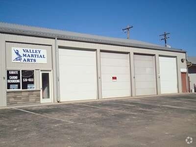
755 Highway 105
Colorado Springs, CO
Elephant Rock Acres
71100-15-007
LOTS 1 TO 13 INC BLK 4 ELEPHANT ROCK ACRES, TOG WITH THAT PORT OF 75 FT HWY R/W LY S OF SD BLK 4 AND BET WESTWARD LN & MEADOW LN, SUBJ TO EASEMENT AS REC IN VAC ORD AT BK 6664-596
Commercialbuilding
El Paso
X
Colorado
08041C0257G
1-13
2024
1.92 AC
2025
Northwest
003712
Colorado Springs
36,389 SF
DEMOGRAPHICS near 755 Highway 105
1 Mile
3 Mile
5 Mile
2024 Total Population
2,957
20,950
34,903
2029 Population
3,135
21,829
36,483
Pop Growth 2024-2029
+ 6.02%
+ 4.20%
+ 4.53%
Average Age
41
42
42
2024 Total Households
1,096
7,534
12,311
HH Growth 2024-2029
+ 6.11%
+ 4.33%
+ 4.69%
Median Household Inc
$102,729
$125,577
$138,053
Avg Household Size
2.70
2.80
2.80
2024 Avg HH Vehicles
3.00
3.00
3.00
Median Home Value
$596,929
$627,703
$630,256
Median Year Built
1992
1993
1996
Nearby Places
Map Layers
Map Styles
 Street
 Aerial
- Restaurants
- Banks
- Shops
- Fitness
- Groceries
PUBLIC TRANSPORTATION
AIRPORT
City of Colorado Springs Municipal
DRIVE
WALK
Distance
City of Colorado Springs Municipal
41 min
27.3 mi
Nearby Properties
Address
Land Use
TOTAL SIZE
Lot Size
Zoning
Address
Land Use
TOTAL SIZE
Lot Size
Zoning
57,619 SF
3.26 AC
SFD-2
Address
Land Use
TOTAL SIZE
Lot Size
Zoning
22,970 SF
5.45 AC
PUD
Address
Land Use
TOTAL SIZE
Lot Size
Zoning
49,258 SF
3.68 AC
PUD
Address
Land Use
TOTAL SIZE
Lot Size
Zoning
53,026 SF
17.20 AC
RR-5
Address
Land Use
TOTAL SIZE
Lot Size
Zoning
600 SF
40 AC
A-5
Address
Land Use
TOTAL SIZE
Lot Size
Zoning
222,850 SF
20.55 AC
PUD
Address
Land Use
TOTAL SIZE
Lot Size
Zoning
21,695 SF
1.17 AC
BP
Address
Land Use
TOTAL SIZE
Lot Size
Zoning
38,142 SF
7.28 AC
A-5
Address
Land Use
TOTAL SIZE
Lot Size
Zoning
25,600 SF
10.11 AC
CC
Address
Land Use
TOTAL SIZE
Lot Size
Zoning
150,335 SF
28 AC
LI
Address
Land Use
TOTAL SIZE
Lot Size
Zoning
13.14 AC
PUD
Address
Land Use
TOTAL SIZE
Lot Size
Zoning
16,608 SF
1.14 AC
P
Address
Land Use
TOTAL SIZE
Lot Size
Zoning
12,167 SF
1.40 AC
DB
Address
Land Use
TOTAL SIZE
Lot Size
Zoning
272.98 AC
RR-5
Address
Land Use
TOTAL SIZE
Lot Size
Zoning
31,037 SF
9.80 AC
PUD
Address
Land Use
TOTAL SIZE
Lot Size
Zoning
14,684 SF
5 AC
RS-20000
Address
Land Use
TOTAL SIZE
Lot Size
Zoning
16,235 SF
6.08 AC
RR-5
Address
Land Use
TOTAL SIZE
Lot Size
Zoning
16,230 SF
2.81 AC
Address
Land Use
TOTAL SIZE
Lot Size
Zoning
198,725 SF
10.39 AC
PUD
Address
Land Use
TOTAL SIZE
Lot Size
Zoning
1,047.40 AC
OS
Address
Land Use
TOTAL SIZE
Lot Size
Zoning
53,337 SF
12 AC
PCD
Address
Land Use
TOTAL SIZE
Lot Size
Zoning
11,794 SF
17.98 AC
RR-5
Address
Land Use
TOTAL SIZE
Lot Size
Zoning
9,631 SF
15.85 AC
PUD
Address
Land Use
TOTAL SIZE
Lot Size
Zoning
1.68 AC
A-5
Address
Land Use
TOTAL SIZE
Lot Size
Zoning
12.30 AC
CC
Address
Land Use
TOTAL SIZE
Lot Size
Zoning
625 SF
23.13 AC
SFD-2
Address
Land Use
TOTAL SIZE
Lot Size
Zoning
87,656 SF
4.30 AC
I-2
Address
Land Use
TOTAL SIZE
Lot Size
Zoning
21.63 AC
RR-5
Address
Land Use
TOTAL SIZE
Lot Size
Zoning
134,818 SF
6.41 AC
PMD
Address
Land Use
TOTAL SIZE
Lot Size
Zoning
7,107 SF
113.85 AC
PUD RS-200
The World's #1 Commercial Real Estate Marketplace
Connect with us
© 2025 CoStar Group
The information above has been obtained from sources believed reliable. While we do not doubt its accuracy we have not verified it and make no guarantee, warranty or representation about it. It is your responsibility to independently confirm its accuracy and completeness. Any projections, opinions, assumptions, or estimates used are for example only and do not represent the current or future performance of the property. The value of this transaction to you depends on tax and other factors which should be evaluated by your tax, financial, and legal advisors. You and your advisors should conduct a careful, independent investigation of the property to determine to your satisfaction the suitability of the property for your needs.