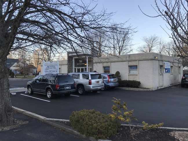
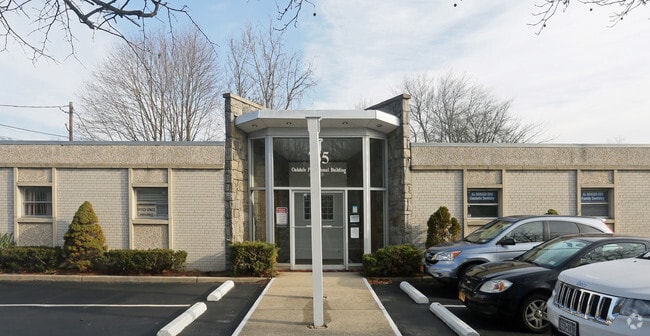
Property Record
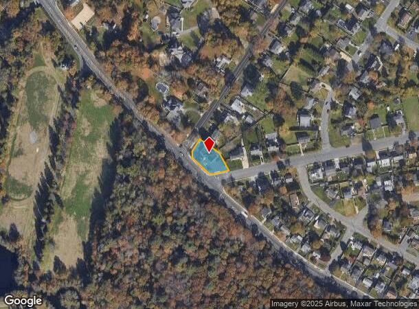
755 Montauk Hwy, Oakdale, NY 11769
NEARBY LISTINGS FOR SALE OR LEASE
Property Detail
755 Montauk Hwy
Nassau County-Suffolk County, NY
X2245040Y186459 N066N00000000
0500-379-00-01-00-024-000
Suffolk
Commercialbuilding
New York
X
100
36103C0901H
0.26 AC
0
Central Suffolk
2024
Long Island (New York)
147702
DEMOGRAPHICS near 755 Montauk Hwy
1 Mile
3 Mile
5 Mile
2024 Total Population
7,449
42,086
108,961
2029 Population
7,484
41,796
107,626
Pop Growth 2024-2029
+ 0.47%
(0.69%)
(1.23%)
Average Age
46
44
43
2024 Total Households
2,991
15,648
39,209
HH Growth 2024-2029
+ 0.53%
(0.80%)
(1.26%)
Median Household Inc
$121,837
$127,276
$122,686
Avg Household Size
2.40
2.60
2.70
2024 Avg HH Vehicles
2.00
2.00
2.00
Median Home Value
$477,222
$530,274
$488,061
Median Year Built
1966
1967
1968
Nearby Places
- Restaurants
- Banks
- Shops
- Fitness
- Groceries
PUBLIC TRANSPORTATION
COMMUTER RAIL
Oakdale Station (Montauk Branch - Long Island Rail Road)
DRIVE
WALK
Distance
Oakdale Station (Montauk Branch - Long Island Rail Road)
2 min
1.2 mi
Sayville Station (Montauk Branch - Long Island Rail Road)
DRIVE
WALK
Distance
Sayville Station (Montauk Branch - Long Island Rail Road)
5 min
2.5 mi
AIRPORT
Long Island MacArthur
DRIVE
WALK
Distance
Long Island MacArthur
12 min
5.1 mi
John F Kennedy International
DRIVE
WALK
Distance
John F Kennedy International
56 min
40.6 mi
SALE & LEASE HISTORY
LISTING DATE
SALE/LEASE

Oct 30, 2023
For Lease
Feb 07, 2017
For Lease
Nearby Properties
Address
Land Use
TOTAL SIZE
Lot Size
Zoning
Address
Land Use
TOTAL SIZE
Lot Size
Zoning
2,057.30 AC
AAA
Address
Land Use
TOTAL SIZE
Lot Size
Zoning
334.30 AC
AAA
Address
Land Use
TOTAL SIZE
Lot Size
Zoning
27.90 AC
AA
Address
Land Use
TOTAL SIZE
Lot Size
Zoning
465.70 AC
AAA
Address
Land Use
TOTAL SIZE
Lot Size
Zoning
13 AC
OSC
Address
Land Use
TOTAL SIZE
Lot Size
Zoning
10,930 SF
175.30 AC
AAA
Address
Land Use
TOTAL SIZE
Lot Size
Zoning
27.63 AC
C
Address
Land Use
TOTAL SIZE
Lot Size
Zoning
216.20 AC
AAA
Address
Land Use
TOTAL SIZE
Lot Size
Zoning
218 AC
AAA
Address
Land Use
TOTAL SIZE
Lot Size
Zoning
26,811 SF
43.20 AC
CA
Address
Land Use
TOTAL SIZE
Lot Size
Zoning
339.70 AC
AAA
Address
Land Use
TOTAL SIZE
Lot Size
Zoning
41 AC
PDDGROI
Address
Land Use
TOTAL SIZE
Lot Size
Zoning
31.30 AC
IND1
Address
Land Use
TOTAL SIZE
Lot Size
Zoning
23.80 AC
AAA
Address
Land Use
TOTAL SIZE
Lot Size
Zoning
8.65 AC
GSC
Address
Land Use
TOTAL SIZE
Lot Size
Zoning
3.16 AC
A
Address
Land Use
TOTAL SIZE
Lot Size
Zoning
17.51 AC
Address
Land Use
TOTAL SIZE
Lot Size
Zoning
20.29 AC
CA
Address
Land Use
TOTAL SIZE
Lot Size
Zoning
252.70 AC
AAA
Address
Land Use
TOTAL SIZE
Lot Size
Zoning
16 AC
AA
Address
Land Use
TOTAL SIZE
Lot Size
Zoning
27.10 AC
AAA
Address
Land Use
TOTAL SIZE
Lot Size
Zoning
722 SF
24.39 AC
BUS3
Address
Land Use
TOTAL SIZE
Lot Size
Zoning
25 AC
AA
Address
Land Use
TOTAL SIZE
Lot Size
Zoning
6.14 AC
Address
Land Use
TOTAL SIZE
Lot Size
Zoning
5,880 SF
2.10 AC
RWB
Address
Land Use
TOTAL SIZE
Lot Size
Zoning
15 AC
AA
Address
Land Use
TOTAL SIZE
Lot Size
Zoning
14.30 AC
B
Address
Land Use
TOTAL SIZE
Lot Size
Zoning
14 AC
AAA
Address
Land Use
TOTAL SIZE
Lot Size
Zoning
Address
Land Use
TOTAL SIZE
Lot Size
Zoning
17.90 AC
AAA
The World's #1 Commercial Real Estate Marketplace
Connect with us
© 2025 CoStar Group
The information above has been obtained from sources believed reliable. While we do not doubt its accuracy we have not verified it and make no guarantee, warranty or representation about it. It is your responsibility to independently confirm its accuracy and completeness. Any projections, opinions, assumptions, or estimates used are for example only and do not represent the current or future performance of the property. The value of this transaction to you depends on tax and other factors which should be evaluated by your tax, financial, and legal advisors. You and your advisors should conduct a careful, independent investigation of the property to determine to your satisfaction the suitability of the property for your needs.