Property Record
755 N 9Th Ave, Brighton, CO 80603
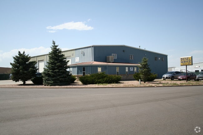


Property Detail
755 N 9Th Ave
Greeley, CO
BRI BIP2-6 L6 BLK2 BRIGHTON INDUSTRIAL PARK LTD
R6296686
Weld
Miscellaneous
Colorado
B and X Area of moderate flood hazard, usually the area between the limits of the 100-year and 500-year floods.
6
2024
1 AC
2025
Weld County
001911
Denver
9,603 SF
NEARBY LISTINGS FOR SALE OR LEASE
DEMOGRAPHICS near 755 N 9Th Ave
1 mile
3 mile
5 mile
2025 Total Population
6,492
36,312
61,674
2030 Population
6,748
38,106
65,744
Pop Growth 2025-2030
+ 3.94%
+ 4.94%
+ 6.60%
Average Age
37
38
38
2025 Total Households
1,891
12,146
20,682
HH Growth 2025-2030
+ 4.18%
+ 5.27%
+ 6.90%
Median Household Inc
$95,181
$97,023
$111,246
Avg Household Size
3.00
2.90
2.90
2025 Avg HH Vehicles
2.00
2.00
2.00
Median Home Value
$456,138
$492,975
$552,785
Median Year Built
1986
1996
2003
Nearby Places
Map Layers
Map Styles
 Street
 Aerial
Transit
 Traffic
 Biking
Places
Listings with unknown addresses are not visible on the map
- Restaurants
- Banks
- Shops
- Fitness
- Groceries
PUBLIC TRANSPORTATION
AIRPORT
Denver International
Drive
Walk
Distance
Denver International
29 min
22.7 mi
SALE & LEASE HISTORY
LISTING DATE
SALE/LEASE

Nov 11, 2024
For Lease
Nearby Properties
Address
Land Use
TOTAL SIZE
Lot Size
Zoning
Address
Land Use
TOTAL SIZE
Lot Size
Zoning
566,409 SF
1.66 AC
Address
Land Use
TOTAL SIZE
Lot Size
Zoning
413,138 SF
20.74 AC
Address
Land Use
TOTAL SIZE
Lot Size
Zoning
113,764 SF
4.24 AC
Address
Land Use
TOTAL SIZE
Lot Size
Zoning
119,714 SF
4.93 AC
Address
Land Use
TOTAL SIZE
Lot Size
Zoning
116,223 SF
7.38 AC
Address
Land Use
TOTAL SIZE
Lot Size
Zoning
71,673 SF
7.59 AC
Address
Land Use
TOTAL SIZE
Lot Size
Zoning
533,981 SF
112.40 AC
Address
Land Use
TOTAL SIZE
Lot Size
Zoning
124,238 SF
62.61 AC
Address
Land Use
TOTAL SIZE
Lot Size
Zoning
161,096 SF
82.69 AC
Address
Land Use
TOTAL SIZE
Lot Size
Zoning
59,923 SF
1.83 AC
Address
Land Use
TOTAL SIZE
Lot Size
Zoning
266,280 SF
12.68 AC
Address
Land Use
TOTAL SIZE
Lot Size
Zoning
223,459 SF
27.46 AC
Address
Land Use
TOTAL SIZE
Lot Size
Zoning
274,367 SF
65.77 AC
Address
Land Use
TOTAL SIZE
Lot Size
Zoning
217,236 SF
55.97 AC
Address
Land Use
TOTAL SIZE
Lot Size
Zoning
281,164 SF
15.57 AC
Address
Land Use
TOTAL SIZE
Lot Size
Zoning
91,534 SF
23.03 AC
Address
Land Use
TOTAL SIZE
Lot Size
Zoning
85,398 SF
15 AC
Address
Land Use
TOTAL SIZE
Lot Size
Zoning
182,210 SF
17.01 AC
Address
Land Use
TOTAL SIZE
Lot Size
Zoning
65,492 SF
7.50 AC
Address
Land Use
TOTAL SIZE
Lot Size
Zoning
175,091 SF
9.43 AC
Address
Land Use
TOTAL SIZE
Lot Size
Zoning
60,400 SF
19.12 AC
Address
Land Use
TOTAL SIZE
Lot Size
Zoning
260,526 SF
9.17 AC
Address
Land Use
TOTAL SIZE
Lot Size
Zoning
70,573 SF
7.83 AC
Address
Land Use
TOTAL SIZE
Lot Size
Zoning
37,126 SF
33.04 AC
Address
Land Use
TOTAL SIZE
Lot Size
Zoning
40,000 SF
4.10 AC
Address
Land Use
TOTAL SIZE
Lot Size
Zoning
34,345 SF
13.11 AC
A1
Address
Land Use
TOTAL SIZE
Lot Size
Zoning
95,310 SF
20.96 AC
A1
Address
Land Use
TOTAL SIZE
Lot Size
Zoning
59,015 SF
9.44 AC
Address
Land Use
TOTAL SIZE
Lot Size
Zoning
65,892 SF
4.87 AC
The World's #1 Commercial Real Estate Marketplace
Connect with us
© 2026 CoStar Group
The information above has been obtained from sources believed reliable. While we do not doubt its accuracy we have not verified it and make no guarantee, warranty or representation about it. It is your responsibility to independently confirm its accuracy and completeness. Any projections, opinions, assumptions, or estimates used are for example only and do not represent the current or future performance of the property. The value of this transaction to you depends on tax and other factors which should be evaluated by your tax, financial, and legal advisors. You and your advisors should conduct a careful, independent investigation of the property to determine to your satisfaction the suitability of the property for your needs.