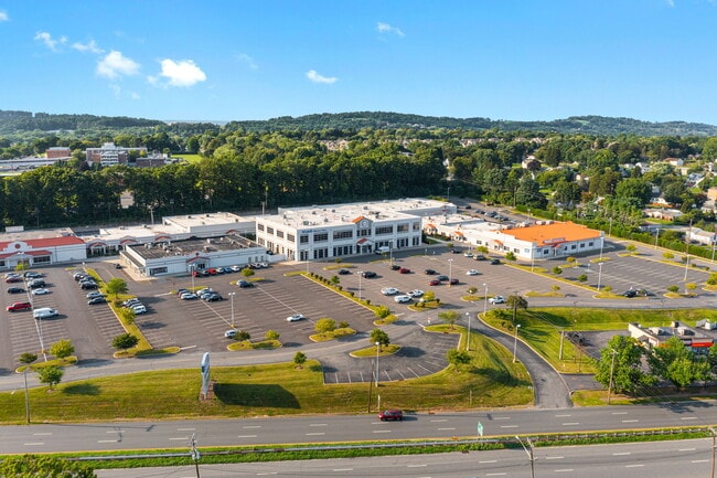
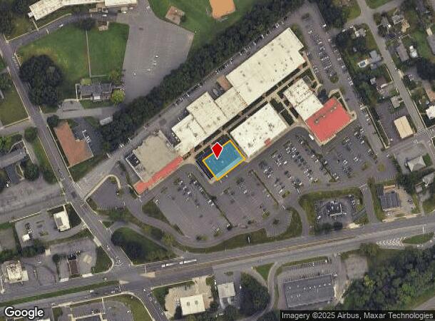
Property Record
755 Us Highway 22 Pkwy, Lopatcong, NJ 08865
NEARBY LISTINGS FOR SALE OR LEASE
Property Detail
755 Us Highway 22 Pkwy
Allentown-Bethlehem-Easton, PA-NJ
Hillcrest Condo
15-00058-0000-00024-07
ADDITIONAL LOTS: RITE AID/4 OTHERS
Commercialnec
Warren
X
New Jersey
34041C0283E
24.7
2024
0.32 AC
2025
Warren County
030800
Northern New Jersey
DEMOGRAPHICS near 755 Us Highway 22 Pkwy
1 Mile
3 Mile
5 Mile
2024 Total Population
11,223
72,459
112,861
2029 Population
11,583
73,781
114,417
Pop Growth 2024-2029
+ 3.21%
+ 1.82%
+ 1.38%
Average Age
42
40
41
2024 Total Households
4,870
26,999
42,629
HH Growth 2024-2029
+ 3.43%
+ 1.97%
+ 1.48%
Median Household Inc
$56,773
$69,951
$78,273
Avg Household Size
2.20
2.40
2.50
2024 Avg HH Vehicles
2.00
2.00
2.00
Median Home Value
$192,353
$230,144
$247,136
Median Year Built
1961
1955
1962
Nearby Places
Map Layers
Map Styles
 Street
 Aerial
- Restaurants
- Banks
- Shops
- Fitness
- Groceries
PUBLIC TRANSPORTATION
AIRPORT
Lehigh Valley International
DRIVE
WALK
Distance
Lehigh Valley International
28 min
16.5 mi
Freight Ports
Port of Philadelphia
DRIVE
WALK
Distance
Port of Philadelphia
104 min
63.7 mi
SALE & LEASE HISTORY
LISTING DATE
SALE/LEASE

Aug 15, 2021
For Sale
Nearby Properties
Address
Land Use
TOTAL SIZE
Lot Size
Zoning
Address
Land Use
TOTAL SIZE
Lot Size
Zoning
330,000 SF
121.88 AC
R150
Address
Land Use
TOTAL SIZE
Lot Size
Zoning
511,200 SF
66.74 AC
HBRM
Address
Land Use
TOTAL SIZE
Lot Size
Zoning
54.61 AC
Address
Land Use
TOTAL SIZE
Lot Size
Zoning
48.27 AC
I2RA
Address
Land Use
TOTAL SIZE
Lot Size
Zoning
9.80 AC
B-1
Address
Land Use
TOTAL SIZE
Lot Size
Zoning
27.73 AC
RA-7
Address
Land Use
TOTAL SIZE
Lot Size
Zoning
20.65 AC
HBRM
Address
Land Use
TOTAL SIZE
Lot Size
Zoning
15,080 SF
34.28 AC
R120
Address
Land Use
TOTAL SIZE
Lot Size
Zoning
16.54 AC
Address
Land Use
TOTAL SIZE
Lot Size
Zoning
87,508 SF
40.79 AC
CCE
Address
Land Use
TOTAL SIZE
Lot Size
Zoning
47.55 AC
B-3
Address
Land Use
TOTAL SIZE
Lot Size
Zoning
48.60 AC
B-3
Address
Land Use
TOTAL SIZE
Lot Size
Zoning
14.60 AC
RA-7
Address
Land Use
TOTAL SIZE
Lot Size
Zoning
28.79 AC
R-1
Address
Land Use
TOTAL SIZE
Lot Size
Zoning
13,916 SF
9.47 AC
RLD
Address
Land Use
TOTAL SIZE
Lot Size
Zoning
17.06 AC
R-75
Address
Land Use
TOTAL SIZE
Lot Size
Zoning
17.65 AC
I-1
Address
Land Use
TOTAL SIZE
Lot Size
Zoning
127,731 SF
56.29 AC
R12
Address
Land Use
TOTAL SIZE
Lot Size
Zoning
7.43 AC
R-50
Address
Land Use
TOTAL SIZE
Lot Size
Zoning
43.49 AC
B-3
Address
Land Use
TOTAL SIZE
Lot Size
Zoning
15.02 AC
ROM
Address
Land Use
TOTAL SIZE
Lot Size
Zoning
5,600 SF
24.18 AC
B-I
Address
Land Use
TOTAL SIZE
Lot Size
Zoning
6,966 SF
8.86 AC
RMD
Address
Land Use
TOTAL SIZE
Lot Size
Zoning
7.21 AC
B-3
Address
Land Use
TOTAL SIZE
Lot Size
Zoning
20.75 AC
B-1
Address
Land Use
TOTAL SIZE
Lot Size
Zoning
0.67 AC
B-I
Address
Land Use
TOTAL SIZE
Lot Size
Zoning
84,805 SF
12.20 AC
CHDD
Address
Land Use
TOTAL SIZE
Lot Size
Zoning
12.16 AC
Address
Land Use
TOTAL SIZE
Lot Size
Zoning
1,852 SF
10.43 AC
PO
Address
Land Use
TOTAL SIZE
Lot Size
Zoning
32.92 AC
HBRM
The World's #1 Commercial Real Estate Marketplace
Connect with us
© 2025 CoStar Group
The information above has been obtained from sources believed reliable. While we do not doubt its accuracy we have not verified it and make no guarantee, warranty or representation about it. It is your responsibility to independently confirm its accuracy and completeness. Any projections, opinions, assumptions, or estimates used are for example only and do not represent the current or future performance of the property. The value of this transaction to you depends on tax and other factors which should be evaluated by your tax, financial, and legal advisors. You and your advisors should conduct a careful, independent investigation of the property to determine to your satisfaction the suitability of the property for your needs.