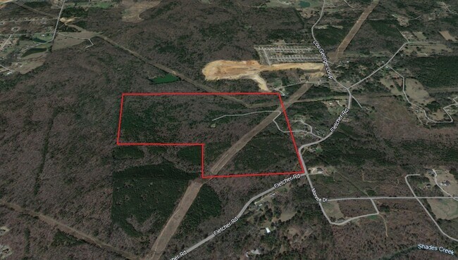
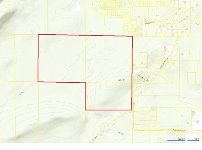
Property Record
7550 Starkey Dr, Bessemer, AL 35022
NEARBY LISTINGS FOR SALE OR LEASE
Property Detail
7550 Starkey Dr
43-00-13-4-000-023.000
N 759 FT OF NW 1/4 OF NE 1/4 SEC 24 TP 20 R 5W
Vacantlandnec
Jefferson
X
Alabama
01073C0667H
40 AC
2023
Bessemer
2024
Birmingham
0142034058
Birmingham-Hoover, AL
DEMOGRAPHICS near 7550 Starkey Dr
1 Mile
3 Mile
5 Mile
2024 Total Population
710
9,732
23,037
2029 Population
700
9,494
22,822
Pop Growth 2024-2029
(1.41%)
(2.45%)
(0.93%)
Average Age
41
41
41
2024 Total Households
269
3,714
8,914
HH Growth 2024-2029
(1.49%)
(2.56%)
(1.13%)
Median Household Inc
$65,333
$67,400
$69,824
Avg Household Size
2.60
2.50
2.50
2024 Avg HH Vehicles
2.00
2.00
2.00
Median Home Value
$236,633
$227,982
$240,708
Median Year Built
1999
2001
1999
Nearby Places
Map Layers
Map Styles
 Street
 Aerial
- Restaurants
- Banks
- Shops
- Fitness
- Groceries
PUBLIC TRANSPORTATION
AIRPORT
Birmingham-Shuttlesworth International
DRIVE
WALK
Distance
Birmingham-Shuttlesworth International
46 min
32.0 mi
Freight Ports
Port of Mobile
DRIVE
WALK
Distance
Port of Mobile
291 min
239.6 mi
SALE & LEASE HISTORY
LISTING DATE
SALE/LEASE

Jan 23, 2024
For Sale
Nearby Properties
Address
Land Use
TOTAL SIZE
Lot Size
Zoning
Address
Land Use
TOTAL SIZE
Lot Size
Zoning
657,600 SF
67.11 AC
I-4
Address
Land Use
TOTAL SIZE
Lot Size
Zoning
499,171 SF
20.23 AC
I4
Address
Land Use
TOTAL SIZE
Lot Size
Zoning
303,730 SF
22.20 AC
I4
Address
Land Use
TOTAL SIZE
Lot Size
Zoning
601,252 SF
41.97 AC
I-4
Address
Land Use
TOTAL SIZE
Lot Size
Zoning
384,230 SF
19.91 AC
I4
Address
Land Use
TOTAL SIZE
Lot Size
Zoning
300,300 SF
13.33 AC
I4
Address
Land Use
TOTAL SIZE
Lot Size
Zoning
284,020 SF
11.20 AC
I4
Address
Land Use
TOTAL SIZE
Lot Size
Zoning
199,420 SF
24.90 AC
I-4
Address
Land Use
TOTAL SIZE
Lot Size
Zoning
298,016 SF
37.36 AC
I4
Address
Land Use
TOTAL SIZE
Lot Size
Zoning
168,300 SF
27.90 AC
I4
Address
Land Use
TOTAL SIZE
Lot Size
Zoning
152,940 SF
33.12 AC
I4
Address
Land Use
TOTAL SIZE
Lot Size
Zoning
240,240 SF
7.33 AC
I4
Address
Land Use
TOTAL SIZE
Lot Size
Zoning
293,440 SF
22.46 AC
I4
Address
Land Use
TOTAL SIZE
Lot Size
Zoning
111,983 SF
1.90 AC
I4/U
Address
Land Use
TOTAL SIZE
Lot Size
Zoning
30,177 SF
2.45 AC
I
Address
Land Use
TOTAL SIZE
Lot Size
Zoning
0.42 AC
U1
Address
Land Use
TOTAL SIZE
Lot Size
Zoning
43,423 SF
8.16 AC
A1
Address
Land Use
TOTAL SIZE
Lot Size
Zoning
51,952 SF
6.24 AC
A1
Address
Land Use
TOTAL SIZE
Lot Size
Zoning
17,700 SF
140 AC
R7
Address
Land Use
TOTAL SIZE
Lot Size
Zoning
51,726 SF
4.40 AC
INST
Address
Land Use
TOTAL SIZE
Lot Size
Zoning
18.80 AC
R7
Address
Land Use
TOTAL SIZE
Lot Size
Zoning
62,588 SF
3.76 AC
A1
Address
Land Use
TOTAL SIZE
Lot Size
Zoning
37,804 SF
7.10 AC
I
Address
Land Use
TOTAL SIZE
Lot Size
Zoning
15,447 SF
19.66 AC
C3
Address
Land Use
TOTAL SIZE
Lot Size
Zoning
41,925 SF
3.84 AC
INST
Address
Land Use
TOTAL SIZE
Lot Size
Zoning
25,194 SF
5 AC
INST
Address
Land Use
TOTAL SIZE
Lot Size
Zoning
41,780 SF
26.70 AC
I1
Address
Land Use
TOTAL SIZE
Lot Size
Zoning
7,380 SF
1.80 AC
A1IR
Address
Land Use
TOTAL SIZE
Lot Size
Zoning
1,745 SF
2.39 AC
C-4
Address
Land Use
TOTAL SIZE
Lot Size
Zoning
10 AC
U1
The World's #1 Commercial Real Estate Marketplace
Connect with us
© 2025 CoStar Group
The information above has been obtained from sources believed reliable. While we do not doubt its accuracy we have not verified it and make no guarantee, warranty or representation about it. It is your responsibility to independently confirm its accuracy and completeness. Any projections, opinions, assumptions, or estimates used are for example only and do not represent the current or future performance of the property. The value of this transaction to you depends on tax and other factors which should be evaluated by your tax, financial, and legal advisors. You and your advisors should conduct a careful, independent investigation of the property to determine to your satisfaction the suitability of the property for your needs.