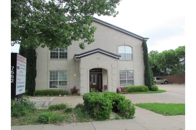
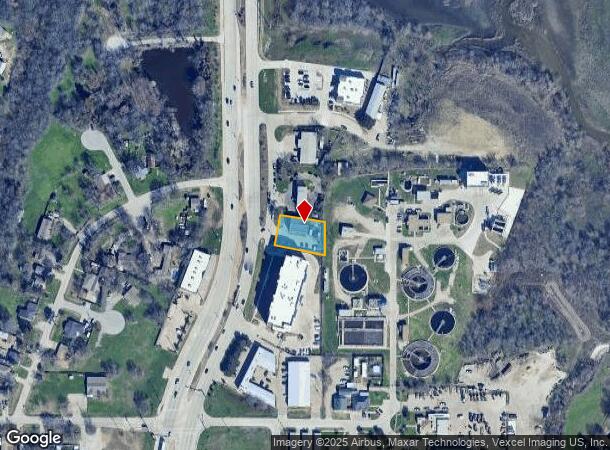
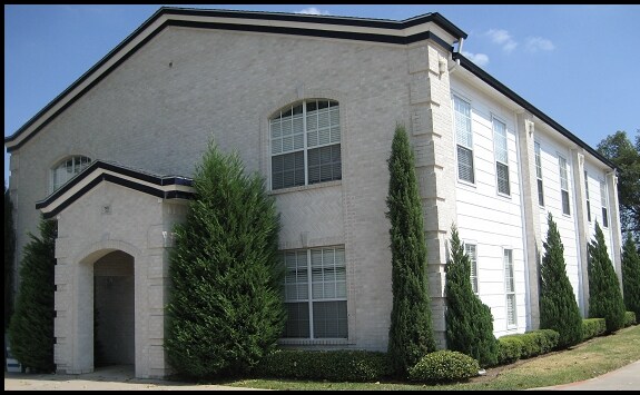
Property Record
7552 Main St, The Colony, TX 75056
Current Lease Availabilities
Property Detail
7552 Main St
Dallas-Fort Worth-Arlington, TX
Garza Lake Estates
R222925
GARZA LAKE ESTATES BLK 3 LOT 15R
Commercialnec
Denton
X
Texas
48113C0025K
15r
2024
0.34 AC
2025
Frisco/The Colony
021521
Dallas/Ft Worth
4,816 SF
NEARBY LISTINGS FOR SALE OR LEASE
DEMOGRAPHICS near 7552 Main St
1 mile
3 mile
5 mile
2024 Total Population
8,897
84,712
235,654
2029 Population
10,676
102,088
286,213
Pop Growth 2024-2029
+ 20.00%
+ 20.51%
+ 21.45%
Average Age
39
39
38
2024 Total Households
3,175
30,350
93,467
HH Growth 2024-2029
+ 20.54%
+ 21.06%
+ 22.21%
Median Household Inc
$101,562
$123,792
$107,915
Avg Household Size
2.80
2.80
2.50
2024 Avg HH Vehicles
2.00
2.00
2.00
Median Home Value
$256,045
$434,691
$453,277
Median Year Built
1982
2005
2009
Nearby Places
Map Layers
Map Styles
 Street
 Aerial
Transit
 Traffic
 Biking
Places
Listings with unknown addresses are not visible on the map
- Restaurants
- Banks
- Shops
- Fitness
- Groceries
PUBLIC TRANSPORTATION
COMMUTER RAIL
Old Town Station (A-train - Denton County Transportation Authority)
Drive
Walk
Distance
Old Town Station (A-train - Denton County Transportation Authority)
15 min
9.1 mi
Hebron Station (A-train - Denton County Transportation Authority)
Drive
Walk
Distance
Hebron Station (A-train - Denton County Transportation Authority)
16 min
10.0 mi
AIRPORT
Dallas-Fort Worth International
Drive
Walk
Distance
Dallas-Fort Worth International
27 min
20.3 mi
Dallas Love Field
Drive
Walk
Distance
Dallas Love Field
38 min
24.9 mi
Freight Ports
Port of Shreveport
Drive
Walk
Distance
Port of Shreveport
241 min
218.2 mi
Nearby Properties
Address
Land Use
TOTAL SIZE
Lot Size
Zoning
Address
Land Use
TOTAL SIZE
Lot Size
Zoning
325,000 SF
47.61 AC
Address
Land Use
TOTAL SIZE
Lot Size
Zoning
526,369 SF
45.84 AC
Address
Land Use
TOTAL SIZE
Lot Size
Zoning
598,569 SF
86.50 AC
Address
Land Use
TOTAL SIZE
Lot Size
Zoning
1,817,951 SF
82 AC
Address
Land Use
TOTAL SIZE
Lot Size
Zoning
419,038 SF
86.50 AC
Address
Land Use
TOTAL SIZE
Lot Size
Zoning
371,385 SF
19.52 AC
Address
Land Use
TOTAL SIZE
Lot Size
Zoning
356,041 SF
18.46 AC
Address
Land Use
TOTAL SIZE
Lot Size
Zoning
462,429 SF
5.70 AC
Address
Land Use
TOTAL SIZE
Lot Size
Zoning
291,446 SF
16.18 AC
Address
Land Use
TOTAL SIZE
Lot Size
Zoning
317,190 SF
13.51 AC
Address
Land Use
TOTAL SIZE
Lot Size
Zoning
344,890 SF
23.63 AC
Address
Land Use
TOTAL SIZE
Lot Size
Zoning
267,413 SF
5.25 AC
Address
Land Use
TOTAL SIZE
Lot Size
Zoning
441,062 SF
21.13 AC
MF-M
Address
Land Use
TOTAL SIZE
Lot Size
Zoning
323,736 SF
14.98 AC
Address
Land Use
TOTAL SIZE
Lot Size
Zoning
638,645 SF
47.87 AC
Address
Land Use
TOTAL SIZE
Lot Size
Zoning
298,494 SF
15.14 AC
Address
Land Use
TOTAL SIZE
Lot Size
Zoning
378,980 SF
4.98 AC
Address
Land Use
TOTAL SIZE
Lot Size
Zoning
251,262 SF
13.97 AC
Address
Land Use
TOTAL SIZE
Lot Size
Zoning
310,913 SF
18.19 AC
2G
Address
Land Use
TOTAL SIZE
Lot Size
Zoning
314,068 SF
14.94 AC
Address
Land Use
TOTAL SIZE
Lot Size
Zoning
252,000 SF
7.01 AC
Address
Land Use
TOTAL SIZE
Lot Size
Zoning
536,530 SF
46.66 AC
Address
Land Use
TOTAL SIZE
Lot Size
Zoning
345,240 SF
23.87 AC
Address
Land Use
TOTAL SIZE
Lot Size
Zoning
330,039 SF
3.65 AC
Address
Land Use
TOTAL SIZE
Lot Size
Zoning
246,565 SF
11 AC
Address
Land Use
TOTAL SIZE
Lot Size
Zoning
99.66 AC
Address
Land Use
TOTAL SIZE
Lot Size
Zoning
93,584 SF
21.41 AC
Address
Land Use
TOTAL SIZE
Lot Size
Zoning
150,506 SF
23.49 AC
Address
Land Use
TOTAL SIZE
Lot Size
Zoning
263,289 SF
4.31 AC
Address
Land Use
TOTAL SIZE
Lot Size
Zoning
166,988 SF
15.66 AC
The World's #1 Commercial Real Estate Marketplace
Connect with us
© 2026 CoStar Group
The information above has been obtained from sources believed reliable. While we do not doubt its accuracy we have not verified it and make no guarantee, warranty or representation about it. It is your responsibility to independently confirm its accuracy and completeness. Any projections, opinions, assumptions, or estimates used are for example only and do not represent the current or future performance of the property. The value of this transaction to you depends on tax and other factors which should be evaluated by your tax, financial, and legal advisors. You and your advisors should conduct a careful, independent investigation of the property to determine to your satisfaction the suitability of the property for your needs.