Property Record
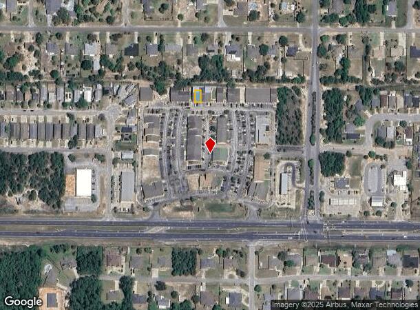
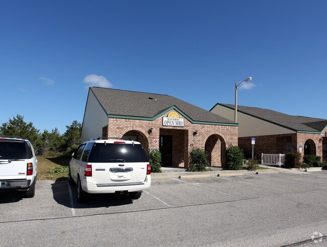
7552 Navarre Pky, Navarre, FL 32566

NEARBY LISTINGS FOR SALE OR LEASE
Property Detail
7552 Navarre Pky
Pensacola-Ferry Pass-Brent, FL
Seasons (The)
24-2S-27-4928-00000-0330
SEASONS (THE) LOT 33 AS DES IN OR 3833 PG 1946
Officebuilding
Santa Rosa
X
Florida
12113C0568H
33
2024
0.04 AC
2025
Navarre
010821
Pensacola
3,240 SF
DEMOGRAPHICS near 7552 Navarre Pky
1 Mile
3 Mile
5 Mile
2024 Total Population
5,333
33,192
52,859
2029 Population
6,089
38,452
61,378
Pop Growth 2024-2029
+ 14.18%
+ 15.85%
+ 16.12%
Average Age
38
40
40
2024 Total Households
2,117
12,636
19,996
HH Growth 2024-2029
+ 14.55%
+ 16.56%
+ 16.69%
Median Household Inc
$84,990
$95,450
$92,525
Avg Household Size
2.50
2.60
2.60
2024 Avg HH Vehicles
2.00
2.00
2.00
Median Home Value
$278,976
$320,867
$314,694
Median Year Built
2003
2002
2002
Nearby Places
Map Layers
Map Styles
 Street
 Aerial
- Restaurants
- Banks
- Shops
- Fitness
- Groceries
PUBLIC TRANSPORTATION
AIRPORT
Pensacola International
DRIVE
WALK
Distance
Pensacola International
48 min
27.2 mi
Eglin AFB/Destin-Ft Walton Beach
DRIVE
WALK
Distance
Eglin AFB/Destin-Ft Walton Beach
57 min
29.0 mi
Freight Ports
Port of Mobile
DRIVE
WALK
Distance
Port of Mobile
101 min
83.1 mi
SALE & LEASE HISTORY
LISTING DATE
SALE/LEASE

Sep 28, 2016
For Sale
Mar 17, 2017
For Sale
Nearby Properties
Address
Land Use
TOTAL SIZE
Lot Size
Zoning
Address
Land Use
TOTAL SIZE
Lot Size
Zoning
344,974 SF
16.11 AC
R3
Address
Land Use
TOTAL SIZE
Lot Size
Zoning
375,552 SF
10.62 AC
PBD
Address
Land Use
TOTAL SIZE
Lot Size
Zoning
242,842 SF
14.77 AC
PBD
Address
Land Use
TOTAL SIZE
Lot Size
Zoning
131,381 SF
8.84 AC
HNB
Address
Land Use
TOTAL SIZE
Lot Size
Zoning
131,381 SF
11.25 AC
HNB
Address
Land Use
TOTAL SIZE
Lot Size
Zoning
23.12 AC
C
Address
Land Use
TOTAL SIZE
Lot Size
Zoning
161,438 SF
5.64 AC
HCD
Address
Land Use
TOTAL SIZE
Lot Size
Zoning
68,134 SF
21.16 AC
R1
Address
Land Use
TOTAL SIZE
Lot Size
Zoning
116,452 SF
4.55 AC
HCD
Address
Land Use
TOTAL SIZE
Lot Size
Zoning
77,417 SF
8.06 AC
HCD
Address
Land Use
TOTAL SIZE
Lot Size
Zoning
65,936 SF
1.86 AC
PBD
Address
Land Use
TOTAL SIZE
Lot Size
Zoning
51,677 SF
17.79 AC
PBD
Address
Land Use
TOTAL SIZE
Lot Size
Zoning
68,334 SF
4.45 AC
HCD
Address
Land Use
TOTAL SIZE
Lot Size
Zoning
85,562 SF
36.21 AC
PBD
Address
Land Use
TOTAL SIZE
Lot Size
Zoning
19,350 SF
9.10 AC
HCD
Address
Land Use
TOTAL SIZE
Lot Size
Zoning
60,854 SF
7.07 AC
HCD
Address
Land Use
TOTAL SIZE
Lot Size
Zoning
14,448 SF
17.20 AC
P
Address
Land Use
TOTAL SIZE
Lot Size
Zoning
48,198 SF
1.76 AC
PBD
Address
Land Use
TOTAL SIZE
Lot Size
Zoning
130,030 SF
36.74 AC
R1A
Address
Land Use
TOTAL SIZE
Lot Size
Zoning
8,714 SF
7 AC
P2-HON
Address
Land Use
TOTAL SIZE
Lot Size
Zoning
39,373 SF
185.18 AC
R1
Address
Land Use
TOTAL SIZE
Lot Size
Zoning
2,046 SF
0.79 AC
HCD
Address
Land Use
TOTAL SIZE
Lot Size
Zoning
3.39 AC
NB-C
Address
Land Use
TOTAL SIZE
Lot Size
Zoning
14,208 SF
4.53 AC
HCD
Address
Land Use
TOTAL SIZE
Lot Size
Zoning
36,749 SF
2.75 AC
HCD
Address
Land Use
TOTAL SIZE
Lot Size
Zoning
26,192 SF
3.82 AC
HCD
Address
Land Use
TOTAL SIZE
Lot Size
Zoning
40,544 SF
2.26 AC
HCD
Address
Land Use
TOTAL SIZE
Lot Size
Zoning
38,588 SF
4.82 AC
HCD
Address
Land Use
TOTAL SIZE
Lot Size
Zoning
400 SF
4.01 AC
HCD
The World's #1 Commercial Real Estate Marketplace
Connect with us
© 2025 CoStar Group
The information above has been obtained from sources believed reliable. While we do not doubt its accuracy we have not verified it and make no guarantee, warranty or representation about it. It is your responsibility to independently confirm its accuracy and completeness. Any projections, opinions, assumptions, or estimates used are for example only and do not represent the current or future performance of the property. The value of this transaction to you depends on tax and other factors which should be evaluated by your tax, financial, and legal advisors. You and your advisors should conduct a careful, independent investigation of the property to determine to your satisfaction the suitability of the property for your needs.