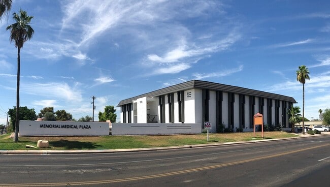
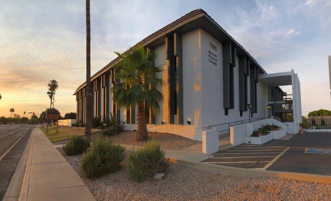
Property Record
7555 E Osborn Rd, Scottsdale, AZ 85251

Current Lease Availabilities
Property Detail
7555 E Osborn Rd
Phoenix-Mesa-Chandler, AZ
SECURITY ACRES AMD MCR 8-59
130-20-001R
Maricopa
Medicalbuilding
Arizona
S-R
1
2025
1.06 AC
2025
Scottsdale South
217600
Phoenix
30,042 SF
NEARBY LISTINGS FOR SALE OR LEASE
DEMOGRAPHICS near 7555 E Osborn Rd
1 mile
3 mile
5 mile
2025 Total Population
23,884
109,133
237,682
2030 Population
25,473
115,259
250,560
Pop Growth 2025-2030
+ 6.65%
+ 5.61%
+ 5.42%
Average Age
39
42
39
2025 Total Households
13,196
54,781
112,322
HH Growth 2025-2030
+ 6.80%
+ 5.82%
+ 5.63%
Median Household Inc
$84,910
$90,901
$82,852
Avg Household Size
1.70
1.90
2.00
2025 Avg HH Vehicles
1.00
2.00
2.00
Median Home Value
$579,575
$631,458
$665,535
Median Year Built
1981
1977
1981
Nearby Places
Map Layers
Map Styles
 Street
 Aerial
Layers
 Traffic
 Biking
Places
Listings with unknown addresses are not visible on the map
- Restaurants
- Banks
- Shops
- Fitness
- Groceries
PUBLIC TRANSPORTATION
AIRPORT
Phoenix Sky Harbor International
Drive
Walk
Distance
Phoenix Sky Harbor International
16 min
8.9 mi
Phoenix-Mesa Gateway
Drive
Walk
Distance
Phoenix-Mesa Gateway
41 min
27.3 mi
Nearby Properties
Address
Land Use
TOTAL SIZE
Lot Size
Zoning
Address
Land Use
TOTAL SIZE
Lot Size
Zoning
Address
Land Use
TOTAL SIZE
Lot Size
Zoning
1,870,689 SF
46.77 AC
I-P
Address
Land Use
TOTAL SIZE
Lot Size
Zoning
2,636,740 SF
21.88 AC
C-DT
Address
Land Use
TOTAL SIZE
Lot Size
Zoning
33,483 SF
7.82 AC
PF
Address
Land Use
TOTAL SIZE
Lot Size
Zoning
1,457,213 SF
41.78 AC
PUD
Address
Land Use
TOTAL SIZE
Lot Size
Zoning
9,160 SF
2.57 AC
DDMU2
Address
Land Use
TOTAL SIZE
Lot Size
Zoning
649,656 SF
10.19 AC
PAD
Address
Land Use
TOTAL SIZE
Lot Size
Zoning
981,325 SF
8.31 AC
Address
Land Use
TOTAL SIZE
Lot Size
Zoning
3.77 AC
PNC
Address
Land Use
TOTAL SIZE
Lot Size
Zoning
44,971 SF
2.06 AC
C-R
Address
Land Use
TOTAL SIZE
Lot Size
Zoning
3,010 SF
35.44 AC
R110
Address
Land Use
TOTAL SIZE
Lot Size
Zoning
307,604 SF
37.83 AC
R-7
Address
Land Use
TOTAL SIZE
Lot Size
Zoning
301,376 SF
8.77 AC
PAD
Address
Land Use
TOTAL SIZE
Lot Size
Zoning
688,550 SF
149.95 AC
R-6
Address
Land Use
TOTAL SIZE
Lot Size
Zoning
776,898 SF
27.32 AC
C-R
Address
Land Use
TOTAL SIZE
Lot Size
Zoning
1,229,384 SF
4.81 AC
Address
Land Use
TOTAL SIZE
Lot Size
Zoning
392,172 SF
7.50 AC
DM2
Address
Land Use
TOTAL SIZE
Lot Size
Zoning
62,497 SF
130.73 AC
R-6
Address
Land Use
TOTAL SIZE
Lot Size
Zoning
439,600 SF
8.52 AC
DDCC2
Address
Land Use
TOTAL SIZE
Lot Size
Zoning
617,776 SF
4.53 AC
DDMU2
Address
Land Use
TOTAL SIZE
Lot Size
Zoning
639,643 SF
5.43 AC
PAD
Address
Land Use
TOTAL SIZE
Lot Size
Zoning
289,633 SF
9.11 AC
R-10
Address
Land Use
TOTAL SIZE
Lot Size
Zoning
530,384 SF
5.24 AC
C-DT
Address
Land Use
TOTAL SIZE
Lot Size
Zoning
Address
Land Use
TOTAL SIZE
Lot Size
Zoning
590,903 SF
9.41 AC
C-DT
Address
Land Use
TOTAL SIZE
Lot Size
Zoning
438,373 SF
11.35 AC
Address
Land Use
TOTAL SIZE
Lot Size
Zoning
245,175 SF
6.94 AC
DDRU2
Address
Land Use
TOTAL SIZE
Lot Size
Zoning
18,758 SF
312
Address
Land Use
TOTAL SIZE
Lot Size
Zoning
153,890 SF
8.54 AC
C-R
Address
Land Use
TOTAL SIZE
Lot Size
Zoning
514,973 SF
4.14 AC
DDMU2
The World's #1 Commercial Real Estate Marketplace
Connect with us
© 2026 CoStar Group
The information above has been obtained from sources believed reliable. While we do not doubt its accuracy we have not verified it and make no guarantee, warranty or representation about it. It is your responsibility to independently confirm its accuracy and completeness. Any projections, opinions, assumptions, or estimates used are for example only and do not represent the current or future performance of the property. The value of this transaction to you depends on tax and other factors which should be evaluated by your tax, financial, and legal advisors. You and your advisors should conduct a careful, independent investigation of the property to determine to your satisfaction the suitability of the property for your needs.