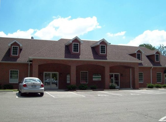
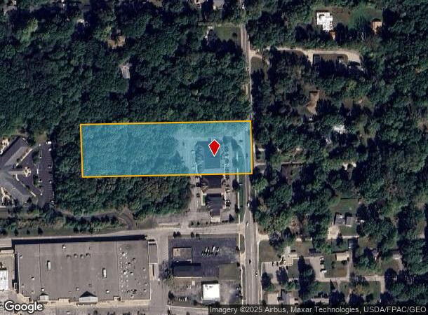
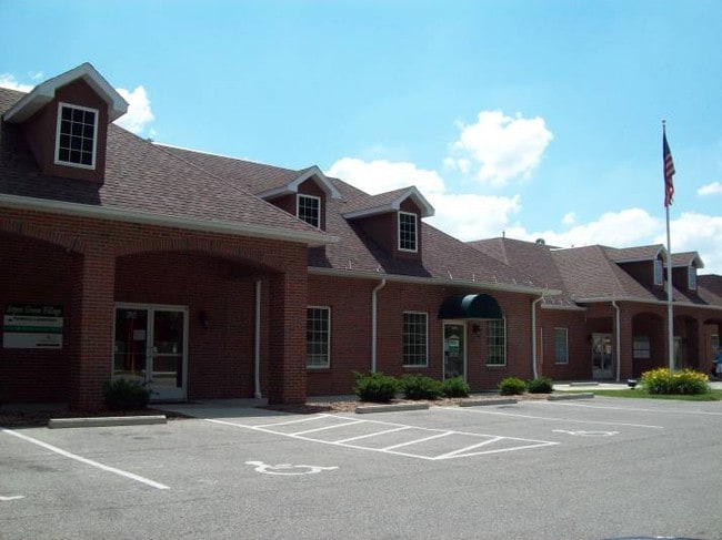
Property Record
7581 Secor Rd, Lambertville, MI 48144
Current Lease Availabilities
NEARBY LISTINGS FOR SALE OR LEASE
-
-
-
-
-
No Photo
-
View all Lambertville listings for lease on LoopNet.com
Property Detail
7581 Secor Rd
02-030-134-10
T8S R7E SEC 30 3.54 AC COM AT THE SE COR OF THE SE 1/4 OF SEC 30, T8S R7E, TH N 00 DEG E 1099.17 FT TO POB; TH S 89 DEG 53'
Medicalbuilding
Monroe
X
Michigan
26115C0344E
3.54 AC
2025
Monroe County
2025
Detroit
833300
Monroe, MI
12,400 SF
DEMOGRAPHICS near 7581 Secor Rd
1 Mile
3 Mile
5 Mile
2024 Total Population
5,490
41,099
113,731
2029 Population
5,512
40,867
112,347
Pop Growth 2024-2029
+ 0.40%
(0.56%)
(1.22%)
Average Age
44
42
41
2024 Total Households
2,190
17,249
48,708
HH Growth 2024-2029
+ 0.37%
(0.61%)
(1.27%)
Median Household Inc
$95,249
$68,986
$64,379
Avg Household Size
2.50
2.30
2.30
2024 Avg HH Vehicles
2.00
2.00
2.00
Median Home Value
$229,225
$178,781
$157,542
Median Year Built
1980
1970
1963
Nearby Places
Map Layers
Map Styles
 Street
 Aerial
- Restaurants
- Banks
- Shops
- Fitness
- Groceries
PUBLIC TRANSPORTATION
AIRPORT
Eugene F Kranz Toledo Express
DRIVE
WALK
Distance
Eugene F Kranz Toledo Express
33 min
23.6 mi
Freight Ports
Port of Baltimore
DRIVE
WALK
Distance
Port of Baltimore
1 min
407.2 mi
Nearby Properties
Address
Land Use
TOTAL SIZE
Lot Size
Zoning
Address
Land Use
TOTAL SIZE
Lot Size
Zoning
165,739 SF
17.77 AC
Address
Land Use
TOTAL SIZE
Lot Size
Zoning
223,900 SF
17.26 AC
Address
Land Use
TOTAL SIZE
Lot Size
Zoning
293,770 SF
13.95 AC
10-RS6
Address
Land Use
TOTAL SIZE
Lot Size
Zoning
222,493 SF
29.88 AC
10-IC
Address
Land Use
TOTAL SIZE
Lot Size
Zoning
61,718 SF
7 AC
Address
Land Use
TOTAL SIZE
Lot Size
Zoning
6.58 AC
Address
Land Use
TOTAL SIZE
Lot Size
Zoning
170,528 SF
15 AC
Address
Land Use
TOTAL SIZE
Lot Size
Zoning
64,980 SF
5.80 AC
Address
Land Use
TOTAL SIZE
Lot Size
Zoning
99,366 SF
1.57 AC
10-RS12
Address
Land Use
TOTAL SIZE
Lot Size
Zoning
49,875 SF
3.97 AC
Address
Land Use
TOTAL SIZE
Lot Size
Zoning
18,970 SF
3.72 AC
Address
Land Use
TOTAL SIZE
Lot Size
Zoning
97,790 SF
5 AC
10-RM36
Address
Land Use
TOTAL SIZE
Lot Size
Zoning
53,933 SF
5.26 AC
Address
Land Use
TOTAL SIZE
Lot Size
Zoning
5.31 AC
Address
Land Use
TOTAL SIZE
Lot Size
Zoning
124,772 SF
4.22 AC
10-IC
Address
Land Use
TOTAL SIZE
Lot Size
Zoning
12,658 SF
2.19 AC
Address
Land Use
TOTAL SIZE
Lot Size
Zoning
30,108 SF
4.43 AC
Address
Land Use
TOTAL SIZE
Lot Size
Zoning
54,786 SF
7 AC
10-RS6
Address
Land Use
TOTAL SIZE
Lot Size
Zoning
34,634 SF
37.38 AC
B2
Address
Land Use
TOTAL SIZE
Lot Size
Zoning
53,246 SF
7 AC
10-RS6
Address
Land Use
TOTAL SIZE
Lot Size
Zoning
6,164 SF
124.64 AC
Address
Land Use
TOTAL SIZE
Lot Size
Zoning
125,354 SF
4.14 AC
10-CR
Address
Land Use
TOTAL SIZE
Lot Size
Zoning
58,048 SF
2 AC
10-CR
Address
Land Use
TOTAL SIZE
Lot Size
Zoning
126,625 SF
12.32 AC
10-CRSO
Address
Land Use
TOTAL SIZE
Lot Size
Zoning
71,463 SF
9.05 AC
10-MX
Address
Land Use
TOTAL SIZE
Lot Size
Zoning
42,066 SF
7.26 AC
10-MX
Address
Land Use
TOTAL SIZE
Lot Size
Zoning
21,566 SF
4.07 AC
10-CR
Address
Land Use
TOTAL SIZE
Lot Size
Zoning
47,124 SF
1 AC
10-CR
Address
Land Use
TOTAL SIZE
Lot Size
Zoning
47,404 SF
1 AC
10-CR
Address
Land Use
TOTAL SIZE
Lot Size
Zoning
6,420 SF
2.12 AC
The World's #1 Commercial Real Estate Marketplace
Connect with us
© 2026 CoStar Group
The information above has been obtained from sources believed reliable. While we do not doubt its accuracy we have not verified it and make no guarantee, warranty or representation about it. It is your responsibility to independently confirm its accuracy and completeness. Any projections, opinions, assumptions, or estimates used are for example only and do not represent the current or future performance of the property. The value of this transaction to you depends on tax and other factors which should be evaluated by your tax, financial, and legal advisors. You and your advisors should conduct a careful, independent investigation of the property to determine to your satisfaction the suitability of the property for your needs.