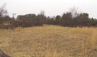
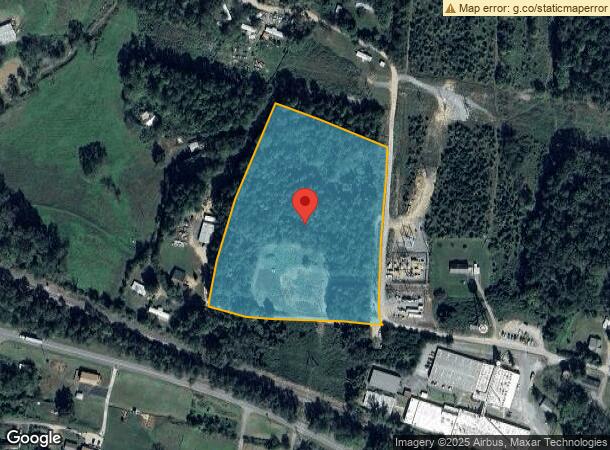
Property Record
7557 Shuford Rd, Connelly Springs, NC 28612
NEARBY LISTINGS FOR SALE OR LEASE
-
-
View all Connelly Springs listings for sale on LoopNet.com
Property Detail
7557 Shuford Rd
20213
7557 REEP RD CONNELLY SPRINGS, NC 28612
Vacantlandnec
Burke
X
North Carolina
3710276200J
7.01 AC
2025
Burke County
2025
Charlotte
021202
Hickory-Lenoir-Morganton, NC
DEMOGRAPHICS near 7557 Shuford Rd
1 Mile
3 Mile
5 Mile
2024 Total Population
1,146
8,966
23,989
2029 Population
1,133
8,922
24,031
Pop Growth 2024-2029
(1.13%)
(0.49%)
+ 0.18%
Average Age
45
44
44
2024 Total Households
461
3,556
9,613
HH Growth 2024-2029
(1.30%)
(0.51%)
+ 0.18%
Median Household Inc
$53,387
$52,553
$56,358
Avg Household Size
2.40
2.40
2.40
2024 Avg HH Vehicles
2.00
2.00
2.00
Median Home Value
$144,782
$145,994
$148,853
Median Year Built
1983
1984
1979
Nearby Places
Map Layers
Map Styles
 Street
 Aerial
- Restaurants
- Banks
- Shops
- Fitness
- Groceries
Nearby Properties
Address
Land Use
TOTAL SIZE
Lot Size
Zoning
Address
Land Use
TOTAL SIZE
Lot Size
Zoning
52,542 SF
RESIDENTIA
Address
Land Use
TOTAL SIZE
Lot Size
Zoning
RESIDENTIA
Address
Land Use
TOTAL SIZE
Lot Size
Zoning
73,872 SF
NO ZONING
Address
Land Use
TOTAL SIZE
Lot Size
Zoning
36,767 SF
7.49 AC
RESIDENTIA
Address
Land Use
TOTAL SIZE
Lot Size
Zoning
42,565 SF
5.10 AC
GENERAL BU
Address
Land Use
TOTAL SIZE
Lot Size
Zoning
51,668 SF
CENTRAL BU
Address
Land Use
TOTAL SIZE
Lot Size
Zoning
205,525 SF
11.79 AC
GENERAL MA
Address
Land Use
TOTAL SIZE
Lot Size
Zoning
7,416 SF
RES LOW DE
Address
Land Use
TOTAL SIZE
Lot Size
Zoning
151,117 SF
26.59 AC
GENERAL MA
Address
Land Use
TOTAL SIZE
Lot Size
Zoning
76.07 AC
GENERAL MA
Address
Land Use
TOTAL SIZE
Lot Size
Zoning
335,352 SF
55.48 AC
INDUSTRIAL
Address
Land Use
TOTAL SIZE
Lot Size
Zoning
12,472 SF
RESIDENTIA
Address
Land Use
TOTAL SIZE
Lot Size
Zoning
38,464 SF
10.37 AC
GENERAL MA
Address
Land Use
TOTAL SIZE
Lot Size
Zoning
26,338 SF
RESIDENTIA
Address
Land Use
TOTAL SIZE
Lot Size
Zoning
10,500 SF
RESIDENTIA
Address
Land Use
TOTAL SIZE
Lot Size
Zoning
4,320 SF
RESIDENTIA
Address
Land Use
TOTAL SIZE
Lot Size
Zoning
3,281 SF
1.75 AC
GENERAL BU
Address
Land Use
TOTAL SIZE
Lot Size
Zoning
357,667 SF
25.47 AC
GENERAL MA
Address
Land Use
TOTAL SIZE
Lot Size
Zoning
295,979 SF
14.96 AC
GENERAL MA
Address
Land Use
TOTAL SIZE
Lot Size
Zoning
3,588 SF
11.85 AC
INDUSTRIAL
Address
Land Use
TOTAL SIZE
Lot Size
Zoning
14,284 SF
RURAL MIXE
Address
Land Use
TOTAL SIZE
Lot Size
Zoning
16,500 SF
RESIDENTIA
Address
Land Use
TOTAL SIZE
Lot Size
Zoning
6,000 SF
5.69 AC
INDUSTRIAL
Address
Land Use
TOTAL SIZE
Lot Size
Zoning
2,400 SF
0.90 AC
HIGHWAY BU
Address
Land Use
TOTAL SIZE
Lot Size
Zoning
10,166 SF
RURAL MIXE
Address
Land Use
TOTAL SIZE
Lot Size
Zoning
9,301 SF
2.44 AC
GENERAL BU
Address
Land Use
TOTAL SIZE
Lot Size
Zoning
10,000 SF
INDUSTRIAL
Address
Land Use
TOTAL SIZE
Lot Size
Zoning
7,200 SF
HIGHWAY BU
Address
Land Use
TOTAL SIZE
Lot Size
Zoning
7,240 SF
RES MEDIUM
Address
Land Use
TOTAL SIZE
Lot Size
Zoning
4,884 SF
2.26 AC
GENERAL BU
The World's #1 Commercial Real Estate Marketplace
Connect with us
© 2025 CoStar Group
The information above has been obtained from sources believed reliable. While we do not doubt its accuracy we have not verified it and make no guarantee, warranty or representation about it. It is your responsibility to independently confirm its accuracy and completeness. Any projections, opinions, assumptions, or estimates used are for example only and do not represent the current or future performance of the property. The value of this transaction to you depends on tax and other factors which should be evaluated by your tax, financial, and legal advisors. You and your advisors should conduct a careful, independent investigation of the property to determine to your satisfaction the suitability of the property for your needs.