Property Record
7557 Willowdale Ave Se, Magnolia, OH 44643
NEARBY LISTINGS FOR SALE OR LEASE
-
-
View all Magnolia listings for sale on LoopNet.com
Property Detail
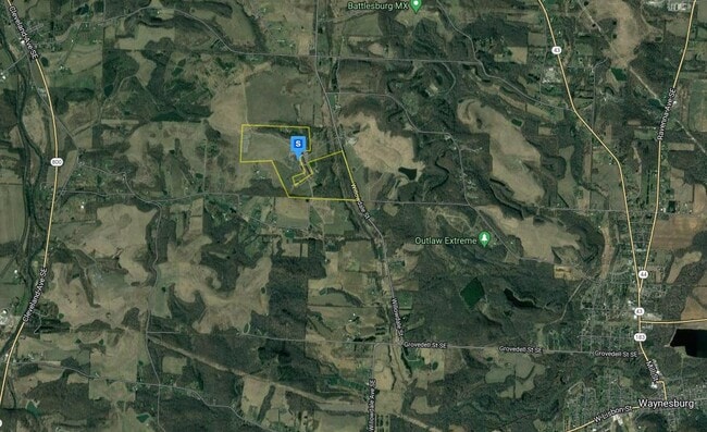
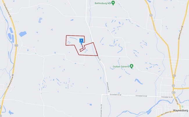
7557 Willowdale Ave Se
Canton-Massillon, OH
18NE 56.97A; 18NW 94.80A (TOTAL 151.77A)
10015469
Stark
Industrialgeneral
Ohio
0
27.26 AC
2025
Stark County
714902
Cleveland
115,843 SF
DEMOGRAPHICS near 7557 Willowdale Ave Se
1 Mile
3 Mile
5 Mile
2024 Total Population
148
3,853
11,152
2029 Population
147
3,807
10,988
Pop Growth 2024-2029
(0.68%)
(1.19%)
(1.47%)
Average Age
44
43
43
2024 Total Households
61
1,550
4,498
HH Growth 2024-2029
0.00%
(1.23%)
(1.47%)
Median Household Inc
$55,555
$63,472
$62,725
Avg Household Size
2.50
2.50
2.40
2024 Avg HH Vehicles
2.00
2.00
2.00
Median Home Value
$171,874
$162,138
$153,182
Median Year Built
1967
1962
1961
Nearby Places
Map Layers
Map Styles
 Street
 Aerial
- Restaurants
- Banks
- Shops
- Fitness
- Groceries
PUBLIC TRANSPORTATION
AIRPORT
Akron-Canton Regional
DRIVE
WALK
Distance
Akron-Canton Regional
35 min
21.4 mi
Freight Ports
Port of Toledo
DRIVE
WALK
Distance
Port of Toledo
207 min
168.6 mi
Nearby Properties
Address
Land Use
TOTAL SIZE
Lot Size
Zoning
Address
Land Use
TOTAL SIZE
Lot Size
Zoning
3,540 SF
159.25 AC
Address
Land Use
TOTAL SIZE
Lot Size
Zoning
1,380 SF
139.98 AC
Address
Land Use
TOTAL SIZE
Lot Size
Zoning
133.82 AC
Address
Land Use
TOTAL SIZE
Lot Size
Zoning
103.11 AC
Address
Land Use
TOTAL SIZE
Lot Size
Zoning
27,063 SF
3.22 AC
Address
Land Use
TOTAL SIZE
Lot Size
Zoning
46,256 SF
8.48 AC
Address
Land Use
TOTAL SIZE
Lot Size
Zoning
12,044 SF
6.64 AC
Address
Land Use
TOTAL SIZE
Lot Size
Zoning
8,580 SF
80.48 AC
Address
Land Use
TOTAL SIZE
Lot Size
Zoning
2,160 SF
151.95 AC
Address
Land Use
TOTAL SIZE
Lot Size
Zoning
14,284 SF
36.46 AC
Address
Land Use
TOTAL SIZE
Lot Size
Zoning
22,498 SF
0.34 AC
Address
Land Use
TOTAL SIZE
Lot Size
Zoning
10,444 SF
1.50 AC
Address
Land Use
TOTAL SIZE
Lot Size
Zoning
11,506 SF
35.06 AC
Address
Land Use
TOTAL SIZE
Lot Size
Zoning
12,882 SF
4.88 AC
Address
Land Use
TOTAL SIZE
Lot Size
Zoning
1,200 SF
164.42 AC
Address
Land Use
TOTAL SIZE
Lot Size
Zoning
3,476 SF
35.58 AC
Address
Land Use
TOTAL SIZE
Lot Size
Zoning
3,508 SF
43.34 AC
Address
Land Use
TOTAL SIZE
Lot Size
Zoning
6,617 SF
40.19 AC
Address
Land Use
TOTAL SIZE
Lot Size
Zoning
4,493 SF
12.12 AC
Address
Land Use
TOTAL SIZE
Lot Size
Zoning
19,725 SF
2.11 AC
Address
Land Use
TOTAL SIZE
Lot Size
Zoning
924 SF
252.74 AC
Address
Land Use
TOTAL SIZE
Lot Size
Zoning
2,896 SF
151.77 AC
Address
Land Use
TOTAL SIZE
Lot Size
Zoning
9,179 SF
2.03 AC
Address
Land Use
TOTAL SIZE
Lot Size
Zoning
2,252 SF
129.93 AC
Address
Land Use
TOTAL SIZE
Lot Size
Zoning
16,148 SF
4.86 AC
Address
Land Use
TOTAL SIZE
Lot Size
Zoning
13,526 SF
0.40 AC
Address
Land Use
TOTAL SIZE
Lot Size
Zoning
13,140 SF
1.86 AC
Address
Land Use
TOTAL SIZE
Lot Size
Zoning
4,313 SF
46.36 AC
Address
Land Use
TOTAL SIZE
Lot Size
Zoning
3,788 SF
46.10 AC
The World's #1 Commercial Real Estate Marketplace
Connect with us
© 2025 CoStar Group
The information above has been obtained from sources believed reliable. While we do not doubt its accuracy we have not verified it and make no guarantee, warranty or representation about it. It is your responsibility to independently confirm its accuracy and completeness. Any projections, opinions, assumptions, or estimates used are for example only and do not represent the current or future performance of the property. The value of this transaction to you depends on tax and other factors which should be evaluated by your tax, financial, and legal advisors. You and your advisors should conduct a careful, independent investigation of the property to determine to your satisfaction the suitability of the property for your needs.