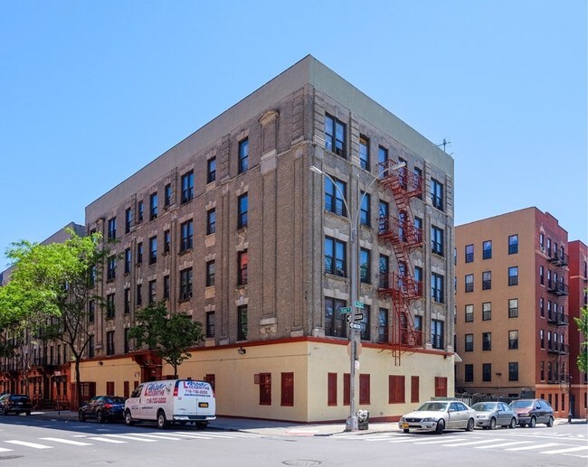
Property Record
756 Fox St, Bronx, NY 10455

Property Detail
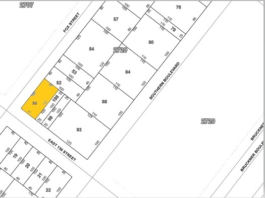
756 Fox St
02720-0050
Bronx
Multifamilydwelling
New York
R7-1
50
B and X Area of moderate flood hazard, usually the area between the limits of the 100-year and 500-year floods.
0.10 AC
2024
Woodstock
2025
Westchester/So Connecticut
008500
New York-Jersey City-White Plains, NY-NJ
20,250 SF
NEARBY LISTINGS FOR SALE OR LEASE
DEMOGRAPHICS near 756 Fox St
1 mile
3 mile
5 mile
2024 Total Population
123,775
1,095,023
2,601,457
2029 Population
115,621
1,015,012
2,416,059
Pop Growth 2024-2029
(6.59%)
(7.31%)
(7.13%)
Average Age
36
38
40
2024 Total Households
42,307
397,950
1,009,135
HH Growth 2024-2029
(7.38%)
(7.89%)
(7.51%)
Median Household Inc
$32,317
$39,027
$56,906
Avg Household Size
2.70
2.60
2.40
2024 Avg HH Vehicles
.00
.00
.00
Median Home Value
$426,774
$573,863
$718,261
Median Year Built
1973
1953
1951
Nearby Places
Map Layers
Map Styles
 Street
 Aerial
Transit
 Traffic
 Biking
Places
Listings with unknown addresses are not visible on the map
- Restaurants
- Banks
- Shops
- Fitness
- Groceries
PUBLIC TRANSPORTATION
TRANSIT/SUBWAY
Longwood Avenue (6 - New York MTA Subway (The Subway))
Drive
Walk
Distance
Longwood Avenue (6 - New York MTA Subway (The Subway))
1 min
3 min
0.2 mi
Prospect Avenue (2,5 Line) (2 - New York MTA Subway (The Subway), 5 - New York MTA Subway (The Subway))
Drive
Walk
Distance
Prospect Avenue (2,5 Line) (2 - New York MTA Subway (The Subway), 5 - New York MTA Subway (The Subway))
1 min
8 min
0.4 mi
East 149 Street (6 - New York MTA Subway (The Subway))
Drive
Walk
Distance
East 149 Street (6 - New York MTA Subway (The Subway))
2 min
9 min
0.4 mi
Intervale Avenue (2 - New York MTA Subway (The Subway), 5 - New York MTA Subway (The Subway))
Drive
Walk
Distance
Intervale Avenue (2 - New York MTA Subway (The Subway), 5 - New York MTA Subway (The Subway))
2 min
10 min
0.5 mi
Hunts Point Avenue (6 - New York MTA Subway (The Subway))
Drive
Walk
Distance
Hunts Point Avenue (6 - New York MTA Subway (The Subway))
2 min
11 min
0.6 mi
COMMUTER RAIL
Melrose Station (Harlem Line - Metro-North Commuter Railroad Company (Metro-North))
Drive
Walk
Distance
Melrose Station (Harlem Line - Metro-North Commuter Railroad Company (Metro-North))
6 min
1.7 mi
Yankees-E 153rd Street Station (Hudson Line - Metro-North Commuter Railroad Company (Metro-North))
Drive
Walk
Distance
Yankees-E 153rd Street Station (Hudson Line - Metro-North Commuter Railroad Company (Metro-North))
6 min
3.6 mi
AIRPORT
LaGuardia
Drive
Walk
Distance
LaGuardia
15 min
7.2 mi
John F Kennedy International
Drive
Walk
Distance
John F Kennedy International
28 min
18.5 mi
Newark Liberty International
Drive
Walk
Distance
Newark Liberty International
32 min
25.8 mi
Freight Ports
NY - Red Hook Container Terminal
Drive
Walk
Distance
NY - Red Hook Container Terminal
28 min
15.4 mi
SALE & LEASE HISTORY
LISTING DATE
SALE/LEASE

Jun 11, 2019
For Sale
Nearby Properties
Address
Land Use
TOTAL SIZE
Lot Size
Zoning
Address
Land Use
TOTAL SIZE
Lot Size
Zoning
5,519,372 SF
409.21 AC
C8-2
Address
Land Use
TOTAL SIZE
Lot Size
Zoning
3,693,539 SF
8.37 AC
R8
Address
Land Use
TOTAL SIZE
Lot Size
Zoning
400,160 SF
10.96 AC
R7-2
Address
Land Use
TOTAL SIZE
Lot Size
Zoning
2,278,432 SF
5.99 AC
R7-2
Address
Land Use
TOTAL SIZE
Lot Size
Zoning
873,000 SF
9.95 AC
R7-2
Address
Land Use
TOTAL SIZE
Lot Size
Zoning
891,040 SF
5.63 AC
R8
Address
Land Use
TOTAL SIZE
Lot Size
Zoning
0.36 AC
R8
Address
Land Use
TOTAL SIZE
Lot Size
Zoning
1,311,800 SF
9.89 AC
C4-4
Address
Land Use
TOTAL SIZE
Lot Size
Zoning
207.09 AC
PARK
Address
Land Use
TOTAL SIZE
Lot Size
Zoning
1,012,000 SF
7.79 AC
R6
Address
Land Use
TOTAL SIZE
Lot Size
Zoning
507,265 SF
4.04 AC
C4-4
Address
Land Use
TOTAL SIZE
Lot Size
Zoning
892,550 SF
2.93 AC
M13R8
Address
Land Use
TOTAL SIZE
Lot Size
Zoning
948 SF
282.37 AC
PARK
Address
Land Use
TOTAL SIZE
Lot Size
Zoning
2,531,670 SF
17.15 AC
R7-2
Address
Land Use
TOTAL SIZE
Lot Size
Zoning
390,750 SF
265 AC
PARK
Address
Land Use
TOTAL SIZE
Lot Size
Zoning
620,000 SF
3.31 AC
R7-2
Address
Land Use
TOTAL SIZE
Lot Size
Zoning
480,769 SF
1.21 AC
R8
Address
Land Use
TOTAL SIZE
Lot Size
Zoning
276,285 SF
1.26 AC
R7-2
Address
Land Use
TOTAL SIZE
Lot Size
Zoning
1,392,950 SF
19.67 AC
M2-1
Address
Land Use
TOTAL SIZE
Lot Size
Zoning
293,848 SF
2.98 AC
C8-3
Address
Land Use
TOTAL SIZE
Lot Size
Zoning
426,172 SF
14.30 AC
M3-1
Address
Land Use
TOTAL SIZE
Lot Size
Zoning
491,007 SF
11.85 AC
M3-1
Address
Land Use
TOTAL SIZE
Lot Size
Zoning
286,481 SF
0.62 AC
C6-2
Address
Land Use
TOTAL SIZE
Lot Size
Zoning
566,233 SF
13.25 AC
M3-1
Address
Land Use
TOTAL SIZE
Lot Size
Zoning
291,885 SF
8.86 AC
R8
Address
Land Use
TOTAL SIZE
Lot Size
Zoning
630,000 SF
1.88 AC
C1-9
Address
Land Use
TOTAL SIZE
Lot Size
Zoning
139,333 SF
1.17 AC
C6-3
Address
Land Use
TOTAL SIZE
Lot Size
Zoning
127,000 SF
16.53 AC
M3-1
Address
Land Use
TOTAL SIZE
Lot Size
Zoning
447,145 SF
8.05 AC
M3-1
Address
Land Use
TOTAL SIZE
Lot Size
Zoning
1,291,359 SF
12 AC
R7-2
The World's #1 Commercial Real Estate Marketplace
Connect with us
© 2026 CoStar Group
The information above has been obtained from sources believed reliable. While we do not doubt its accuracy we have not verified it and make no guarantee, warranty or representation about it. It is your responsibility to independently confirm its accuracy and completeness. Any projections, opinions, assumptions, or estimates used are for example only and do not represent the current or future performance of the property. The value of this transaction to you depends on tax and other factors which should be evaluated by your tax, financial, and legal advisors. You and your advisors should conduct a careful, independent investigation of the property to determine to your satisfaction the suitability of the property for your needs.