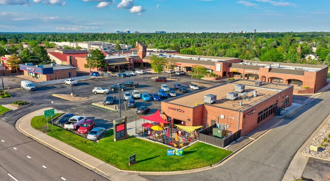
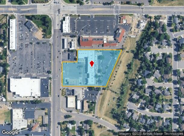
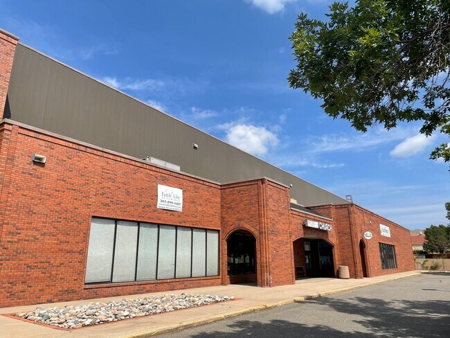
Property Record
7562 S University Blvd, Centennial, CO 80122
NEARBY LISTINGS FOR SALE OR LEASE
Property Detail
7562 S University Blvd
Denver-Aurora-Lakewood, CO
Carolyns Plat
2077-36-2-34-001
SUBDIVISIONCD 009045 SUBDIVISIONNAME CAROLYNS PLAT BLOCK 001 LOT 001 LOT 1 BLK 1 CAROLYNS PLAT
Storebuilding
Arapahoe
X
Colorado
08005C0454L
001,1
2023
4.01 AC
2024
South
005630
Denver
66,616 SF
DEMOGRAPHICS near 7562 S University Blvd
1 Mile
3 Mile
5 Mile
2024 Total Population
14,605
105,857
278,196
2029 Population
14,465
110,109
294,086
Pop Growth 2024-2029
(0.96%)
+ 4.02%
+ 5.71%
Average Age
44
43
41
2024 Total Households
5,909
41,736
112,166
HH Growth 2024-2029
(0.93%)
+ 4.16%
+ 5.44%
Median Household Inc
$107,635
$121,690
$116,552
Avg Household Size
2.40
2.50
2.40
2024 Avg HH Vehicles
2.00
2.00
2.00
Median Home Value
$629,712
$657,966
$660,548
Median Year Built
1977
1983
1990
Nearby Places
Map Layers
Map Styles
 Street
 Aerial
- Restaurants
- Banks
- Shops
- Fitness
- Groceries
PUBLIC TRANSPORTATION
AIRPORT
Denver International
DRIVE
WALK
Distance
Denver International
44 min
33.7 mi
Freight Ports
Tulsa Port Of Catoosa
DRIVE
WALK
Distance
Tulsa Port Of Catoosa
736 min
719.3 mi
SALE & LEASE HISTORY
LISTING DATE
SALE/LEASE

Sep 24, 2016
For Lease
Oct 28, 2019
For Sale
Feb 05, 2019
For Lease
Aug 16, 2022
For Lease
Nearby Properties
Address
Land Use
TOTAL SIZE
Lot Size
Zoning
Address
Land Use
TOTAL SIZE
Lot Size
Zoning
390,078 SF
38.27 AC
Address
Land Use
TOTAL SIZE
Lot Size
Zoning
207,637 SF
28.17 AC
PDU
Address
Land Use
TOTAL SIZE
Lot Size
Zoning
248,965 SF
70.73 AC
Address
Land Use
TOTAL SIZE
Lot Size
Zoning
622,103 SF
24.61 AC
PDU
Address
Land Use
TOTAL SIZE
Lot Size
Zoning
253,902 SF
34.30 AC
PDU
Address
Land Use
TOTAL SIZE
Lot Size
Zoning
488,998 SF
32.43 AC
PDU
Address
Land Use
TOTAL SIZE
Lot Size
Zoning
169,233 SF
12.17 AC
PDU
Address
Land Use
TOTAL SIZE
Lot Size
Zoning
475,502 SF
36 AC
PDU
Address
Land Use
TOTAL SIZE
Lot Size
Zoning
167,287 SF
13.65 AC
Address
Land Use
TOTAL SIZE
Lot Size
Zoning
150,767 SF
14.49 AC
PDU
Address
Land Use
TOTAL SIZE
Lot Size
Zoning
177,772 SF
16 AC
Address
Land Use
TOTAL SIZE
Lot Size
Zoning
163,695 SF
22.90 AC
Address
Land Use
TOTAL SIZE
Lot Size
Zoning
329,937 SF
35.07 AC
PUD
Address
Land Use
TOTAL SIZE
Lot Size
Zoning
572,657 SF
0.21 AC
LPD-C
Address
Land Use
TOTAL SIZE
Lot Size
Zoning
411,924 SF
26.85 AC
LPDI
Address
Land Use
TOTAL SIZE
Lot Size
Zoning
192,108 SF
20.03 AC
Address
Land Use
TOTAL SIZE
Lot Size
Zoning
147,856 SF
5.49 AC
PDU
Address
Land Use
TOTAL SIZE
Lot Size
Zoning
375,468 SF
23.28 AC
PDU
Address
Land Use
TOTAL SIZE
Lot Size
Zoning
398,850 SF
22.94 AC
PDU
Address
Land Use
TOTAL SIZE
Lot Size
Zoning
312,130 SF
20.63 AC
PDU
Address
Land Use
TOTAL SIZE
Lot Size
Zoning
250,402 SF
21 AC
Address
Land Use
TOTAL SIZE
Lot Size
Zoning
151,211 SF
12.50 AC
PUD
Address
Land Use
TOTAL SIZE
Lot Size
Zoning
196,318 SF
4.50 AC
ARP
Address
Land Use
TOTAL SIZE
Lot Size
Zoning
206,632 SF
33.68 AC
Address
Land Use
TOTAL SIZE
Lot Size
Zoning
111,989 SF
11.22 AC
PDU
Address
Land Use
TOTAL SIZE
Lot Size
Zoning
61,607 SF
11.60 AC
LPD-C
Address
Land Use
TOTAL SIZE
Lot Size
Zoning
463,840 SF
17.63 AC
PDU
Address
Land Use
TOTAL SIZE
Lot Size
Zoning
146,156 SF
4.61 AC
Address
Land Use
TOTAL SIZE
Lot Size
Zoning
248,058 SF
12.24 AC
Address
Land Use
TOTAL SIZE
Lot Size
Zoning
282,692 SF
13.01 AC
The World's #1 Commercial Real Estate Marketplace
Connect with us
© 2025 CoStar Group
The information above has been obtained from sources believed reliable. While we do not doubt its accuracy we have not verified it and make no guarantee, warranty or representation about it. It is your responsibility to independently confirm its accuracy and completeness. Any projections, opinions, assumptions, or estimates used are for example only and do not represent the current or future performance of the property. The value of this transaction to you depends on tax and other factors which should be evaluated by your tax, financial, and legal advisors. You and your advisors should conduct a careful, independent investigation of the property to determine to your satisfaction the suitability of the property for your needs.