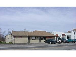
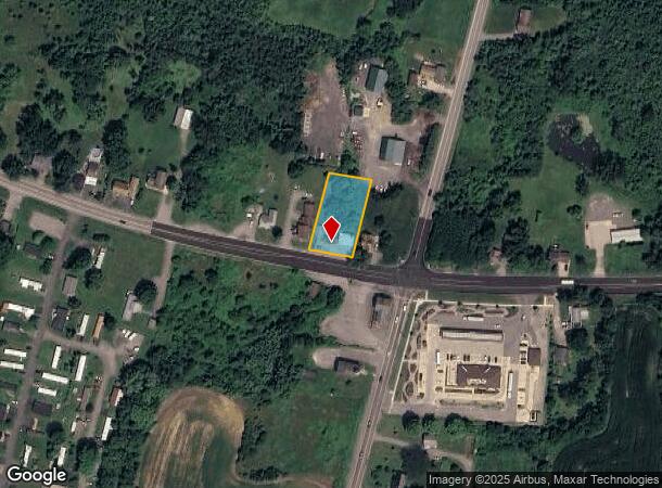
Property Record
7562 W Ridge Rd, Brockport, NY 14420
NEARBY LISTINGS FOR SALE OR LEASE
-
-
View all Brockport listings for sale on LoopNet.com
Property Detail
7562 W Ridge Rd
262489-055-030-0001-005-210
TOWN LOT 2, TOWNSHIP 4 UNRECORDED MAP 1987-13
Autorepair
Monroe
X
New York
36055C0135G
5.210
2025
0.54 AC
2024
Northwest
015200
Rochester
1,710 SF
Rochester, NY
DEMOGRAPHICS near 7562 W Ridge Rd
1 Mile
3 Mile
5 Mile
2024 Total Population
510
12,590
27,661
2029 Population
507
12,514
27,356
Pop Growth 2024-2029
(0.59%)
(0.60%)
(1.10%)
Average Age
42
41
40
2024 Total Households
191
5,318
10,643
HH Growth 2024-2029
(1.05%)
(0.70%)
(1.12%)
Median Household Inc
$72,413
$62,838
$67,748
Avg Household Size
2.70
2.30
2.40
2024 Avg HH Vehicles
2.00
2.00
2.00
Median Home Value
$181,927
$172,791
$174,637
Median Year Built
1988
1970
1973
Nearby Places
- Restaurants
- Banks
- Shops
- Fitness
- Groceries
PUBLIC TRANSPORTATION
AIRPORT
Frederick Douglass/Greater Rochester International
DRIVE
WALK
Distance
Frederick Douglass/Greater Rochester International
24 min
18.1 mi
Freight Ports
Albany, NY Port
DRIVE
WALK
Distance
Albany, NY Port
290 min
244.4 mi
Nearby Properties
Address
Land Use
TOTAL SIZE
Lot Size
Zoning
Address
Land Use
TOTAL SIZE
Lot Size
Zoning
218,648 SF
25.55 AC
05 - COMME
Address
Land Use
TOTAL SIZE
Lot Size
Zoning
86,408 SF
18.90 AC
COM
Address
Land Use
TOTAL SIZE
Lot Size
Zoning
139,634 SF
19.94 AC
05 - COMME
Address
Land Use
TOTAL SIZE
Lot Size
Zoning
614,268 SF
55.10 AC
06 - INDUS
Address
Land Use
TOTAL SIZE
Lot Size
Zoning
226,580 SF
8.70 AC
06 - INDUS
Address
Land Use
TOTAL SIZE
Lot Size
Zoning
7,616 SF
3.80 AC
02 - SINGL
Address
Land Use
TOTAL SIZE
Lot Size
Zoning
29,621 SF
21.57 AC
06 - INDUS
Address
Land Use
TOTAL SIZE
Lot Size
Zoning
267,019 SF
6.80 AC
06 - INDUS
Address
Land Use
TOTAL SIZE
Lot Size
Zoning
2,573 SF
6.66 AC
05 - COMME
Address
Land Use
TOTAL SIZE
Lot Size
Zoning
10,360 SF
5.19 AC
05 - COMME
Address
Land Use
TOTAL SIZE
Lot Size
Zoning
134,904 SF
7.50 AC
06 - INDUS
Address
Land Use
TOTAL SIZE
Lot Size
Zoning
30,960 SF
7.36 AC
RS-10
Address
Land Use
TOTAL SIZE
Lot Size
Zoning
8,448 SF
3.90 AC
05 - COMME
Address
Land Use
TOTAL SIZE
Lot Size
Zoning
56,290 SF
4.99 AC
C
Address
Land Use
TOTAL SIZE
Lot Size
Zoning
25,702 SF
3.96 AC
05 - COMME
Address
Land Use
TOTAL SIZE
Lot Size
Zoning
28,626 SF
5.23 AC
05 - COMME
Address
Land Use
TOTAL SIZE
Lot Size
Zoning
4,624 SF
3.40 AC
05 - COMME
Address
Land Use
TOTAL SIZE
Lot Size
Zoning
2,444 SF
500.50 AC
08 - GOVER
Address
Land Use
TOTAL SIZE
Lot Size
Zoning
10,800 SF
135.13 AC
RS-20
Address
Land Use
TOTAL SIZE
Lot Size
Zoning
44,400 SF
3.13 AC
HC
Address
Land Use
TOTAL SIZE
Lot Size
Zoning
37.16 AC
RS-20
Address
Land Use
TOTAL SIZE
Lot Size
Zoning
18,356 SF
1.30 AC
05 - COMME
Address
Land Use
TOTAL SIZE
Lot Size
Zoning
5,660 SF
2.97 AC
HC
Address
Land Use
TOTAL SIZE
Lot Size
Zoning
6,416 SF
4.09 AC
05 - COMME
Address
Land Use
TOTAL SIZE
Lot Size
Zoning
27.69 AC
01 - NOT Z
Address
Land Use
TOTAL SIZE
Lot Size
Zoning
28,857 SF
3.60 AC
05 - COMME
Address
Land Use
TOTAL SIZE
Lot Size
Zoning
23,687 SF
22.52 AC
C
Address
Land Use
TOTAL SIZE
Lot Size
Zoning
15,808 SF
11 AC
C
Address
Land Use
TOTAL SIZE
Lot Size
Zoning
19.70 AC
Address
Land Use
TOTAL SIZE
Lot Size
Zoning
2,842 SF
0.11 AC
05 - COMME
The World's #1 Commercial Real Estate Marketplace
Connect with us
© 2025 CoStar Group
The information above has been obtained from sources believed reliable. While we do not doubt its accuracy we have not verified it and make no guarantee, warranty or representation about it. It is your responsibility to independently confirm its accuracy and completeness. Any projections, opinions, assumptions, or estimates used are for example only and do not represent the current or future performance of the property. The value of this transaction to you depends on tax and other factors which should be evaluated by your tax, financial, and legal advisors. You and your advisors should conduct a careful, independent investigation of the property to determine to your satisfaction the suitability of the property for your needs.