Property Record
757 Crestwood St, Jacksonville, FL 32208


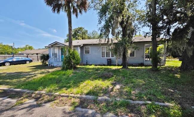
This Property Is For Sale
NEARBY LISTINGS FOR SALE OR LEASE
Property Detail
757 Crestwood St
Jacksonville, FL
Norwood
031855-0000
Duval
Duplex
Florida
X
0.14 AC
12031C0193J
45th & Moncrief
1,402 SF
Jacksonville (Florida)
DEMOGRAPHICS near 757 Crestwood St
1 Mile
3 Mile
5 Mile
2024 Total Population
9,986
82,916
191,180
2029 Population
10,538
88,111
202,293
Pop Growth 2024-2029
+ 5.53%
+ 6.27%
+ 5.81%
Average Age
37
38
39
2024 Total Households
3,986
32,862
76,982
HH Growth 2024-2029
+ 5.52%
+ 6.41%
+ 6.07%
Median Household Inc
$30,810
$30,971
$37,611
Avg Household Size
2.40
2.40
2.30
2024 Avg HH Vehicles
1.00
1.00
1.00
Median Home Value
$99,933
$101,167
$146,717
Median Year Built
1957
1960
1966
Nearby Places
Map Layers
Map Styles
 Street
 Aerial
- Restaurants
- Banks
- Shops
- Fitness
- Groceries
PUBLIC TRANSPORTATION
COMMUTER RAIL
Jacksonville (Silver Meteor - Amtrak, Silver Star - Amtrak)
DRIVE
WALK
Distance
Jacksonville (Silver Meteor - Amtrak, Silver Star - Amtrak)
11 min
5.1 mi
AIRPORT
Jacksonville International
DRIVE
WALK
Distance
Jacksonville International
18 min
11.2 mi
Freight Ports
Jacksonville Port
DRIVE
WALK
Distance
Jacksonville Port
9 min
3.6 mi
Nearby Properties
Address
Land Use
TOTAL SIZE
Lot Size
Zoning
Address
Land Use
TOTAL SIZE
Lot Size
Zoning
705,940 SF
25.12 AC
PBF-1
Address
Land Use
TOTAL SIZE
Lot Size
Zoning
336,852 SF
32.69 AC
IL
Address
Land Use
TOTAL SIZE
Lot Size
Zoning
313,472 SF
35.44 AC
CCBD
Address
Land Use
TOTAL SIZE
Lot Size
Zoning
163,471 SF
7.85 AC
PBF-2
Address
Land Use
TOTAL SIZE
Lot Size
Zoning
144,400 SF
10.32 AC
PBF-2
Address
Land Use
TOTAL SIZE
Lot Size
Zoning
313,741 SF
37.05 AC
RMD-C
Address
Land Use
TOTAL SIZE
Lot Size
Zoning
311,068 SF
18.91 AC
PBF-1
Address
Land Use
TOTAL SIZE
Lot Size
Zoning
119,362 SF
20.32 AC
RMD-C
Address
Land Use
TOTAL SIZE
Lot Size
Zoning
77,356 SF
2.15 AC
PBF-2
Address
Land Use
TOTAL SIZE
Lot Size
Zoning
317,474 SF
17.74 AC
IL
Address
Land Use
TOTAL SIZE
Lot Size
Zoning
679,901 SF
18.30 AC
PBF-1
Address
Land Use
TOTAL SIZE
Lot Size
Zoning
258,700 SF
25.43 AC
RMD-D
Address
Land Use
TOTAL SIZE
Lot Size
Zoning
183,696 SF
43.74 AC
CCG-2
Address
Land Use
TOTAL SIZE
Lot Size
Zoning
5,946 SF
118.58 AC
PBF-1
Address
Land Use
TOTAL SIZE
Lot Size
Zoning
110,290 SF
3.72 AC
PBF-1
Address
Land Use
TOTAL SIZE
Lot Size
Zoning
1,312 SF
56.81 AC
RMD-A
Address
Land Use
TOTAL SIZE
Lot Size
Zoning
764,894 SF
48.70 AC
IW
Address
Land Use
TOTAL SIZE
Lot Size
Zoning
571,166 SF
16.73 AC
IL
Address
Land Use
TOTAL SIZE
Lot Size
Zoning
172,026 SF
47.46 AC
IH
Address
Land Use
TOTAL SIZE
Lot Size
Zoning
154,437 SF
29.28 AC
IL
Address
Land Use
TOTAL SIZE
Lot Size
Zoning
13,764 SF
305.34 AC
IW
Address
Land Use
TOTAL SIZE
Lot Size
Zoning
40,166 SF
48.24 AC
IW
Address
Land Use
TOTAL SIZE
Lot Size
Zoning
138,076 SF
20.68 AC
RLD-60
Address
Land Use
TOTAL SIZE
Lot Size
Zoning
51,492 SF
50.81 AC
IW
Address
Land Use
TOTAL SIZE
Lot Size
Zoning
405,447 SF
14.04 AC
IL
Address
Land Use
TOTAL SIZE
Lot Size
Zoning
175,436 SF
10.62 AC
RMD-D
Address
Land Use
TOTAL SIZE
Lot Size
Zoning
189,046 SF
9.43 AC
RMD-D
Address
Land Use
TOTAL SIZE
Lot Size
Zoning
165,626 SF
10.12 AC
PUD
Address
Land Use
TOTAL SIZE
Lot Size
Zoning
27,722 SF
1.61 AC
PBF-1
Address
Land Use
TOTAL SIZE
Lot Size
Zoning
392,885 SF
61.13 AC
PBF-1
The World's #1 Commercial Real Estate Marketplace
Connect with us
© 2025 CoStar Group
The information above has been obtained from sources believed reliable. While we do not doubt its accuracy we have not verified it and make no guarantee, warranty or representation about it. It is your responsibility to independently confirm its accuracy and completeness. Any projections, opinions, assumptions, or estimates used are for example only and do not represent the current or future performance of the property. The value of this transaction to you depends on tax and other factors which should be evaluated by your tax, financial, and legal advisors. You and your advisors should conduct a careful, independent investigation of the property to determine to your satisfaction the suitability of the property for your needs.