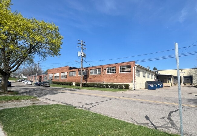
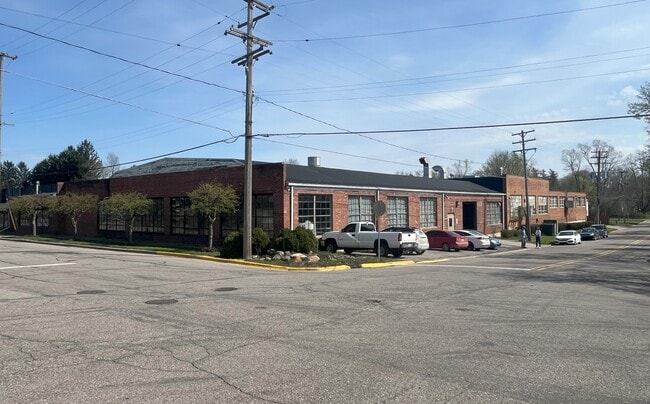
Property Record
757 E Duncan St, Manchester, MI 48158
Current Lease Availabilities
Property Detail
757 E Duncan St
Ann Arbor, MI
OLD SID - PM 16-620-034-00 MA 9-21B LOTS 13 & 14 BLOCK F ALFRED C. TORREYS ADDITION.
16-01-350-002
WASHTENAW
Industrialacreage
Michigan
I-3 URB
13-14
B and X Area of moderate flood hazard, usually the area between the limits of the 100-year and 500-year floods.
0.83 AC
2025
Washtenaw W of 23
2025
Detroit
431000
NEARBY LISTINGS FOR SALE OR LEASE
DEMOGRAPHICS near 757 E Duncan St
1 mile
3 mile
5 mile
2025 Total Population
1,834
3,475
5,941
2030 Population
1,824
3,458
5,932
Pop Growth 2025-2030
(0.55%)
(0.49%)
(0.15%)
Average Age
45
45
46
2025 Total Households
837
1,503
2,468
HH Growth 2025-2030
(0.36%)
(0.40%)
(0.12%)
Median Household Inc
$82,042
$86,723
$93,155
Avg Household Size
2.20
2.30
2.40
2025 Avg HH Vehicles
2.00
2.00
2.00
Median Home Value
$235,687
$272,643
$305,969
Median Year Built
1971
1975
1975
Nearby Places
Map Layers
Map Styles
 Street
 Aerial
Layers
 Traffic
 Biking
Places
Listings with unknown addresses are not visible on the map
- Restaurants
- Banks
- Shops
- Fitness
- Groceries
Nearby Properties
Address
Land Use
TOTAL SIZE
Lot Size
Zoning
Address
Land Use
TOTAL SIZE
Lot Size
Zoning
89,091 SF
8.36 AC
I-2 GEN
Address
Land Use
TOTAL SIZE
Lot Size
Zoning
231,551 SF
20.94 AC
I-2 GEN
Address
Land Use
TOTAL SIZE
Lot Size
Zoning
78,345 SF
7.32 AC
CM COMM
Address
Land Use
TOTAL SIZE
Lot Size
Zoning
2,881 SF
61.48 AC
AG AGR
Address
Land Use
TOTAL SIZE
Lot Size
Zoning
3,176 SF
28.45 AC
AR AGR
Address
Land Use
TOTAL SIZE
Lot Size
Zoning
6,966 SF
53.16 AC
Address
Land Use
TOTAL SIZE
Lot Size
Zoning
180 SF
18.96 AC
AG AGR
Address
Land Use
TOTAL SIZE
Lot Size
Zoning
18,824 SF
5.35 AC
BI
Address
Land Use
TOTAL SIZE
Lot Size
Zoning
22,701 SF
AG AGR
Address
Land Use
TOTAL SIZE
Lot Size
Zoning
19,570 SF
9.23 AC
I-2 GEN
Address
Land Use
TOTAL SIZE
Lot Size
Zoning
37 AC
R-1B SI
Address
Land Use
TOTAL SIZE
Lot Size
Zoning
28,172 SF
4.31 AC
R-2B MU
Address
Land Use
TOTAL SIZE
Lot Size
Zoning
1,825 SF
AG
Address
Land Use
TOTAL SIZE
Lot Size
Zoning
43,197 SF
4.20 AC
I-3 URB
Address
Land Use
TOTAL SIZE
Lot Size
Zoning
2,143 SF
80 AC
AR AGR
Address
Land Use
TOTAL SIZE
Lot Size
Zoning
8,946 SF
2.92 AC
C-2 GEN
Address
Land Use
TOTAL SIZE
Lot Size
Zoning
2,409 SF
110.78 AC
AG
Address
Land Use
TOTAL SIZE
Lot Size
Zoning
2,525 SF
50.61 AC
AG
Address
Land Use
TOTAL SIZE
Lot Size
Zoning
2,604 SF
159.93 AC
FH
Address
Land Use
TOTAL SIZE
Lot Size
Zoning
1,892 SF
120.81 AC
AG
Address
Land Use
TOTAL SIZE
Lot Size
Zoning
3,224 SF
80 AC
FH
Address
Land Use
TOTAL SIZE
Lot Size
Zoning
8,256 SF
11 AC
Address
Land Use
TOTAL SIZE
Lot Size
Zoning
2,671 SF
145.40 AC
AG
Address
Land Use
TOTAL SIZE
Lot Size
Zoning
3,900 SF
40 AC
BI
Address
Land Use
TOTAL SIZE
Lot Size
Zoning
2,456 SF
80 AC
AR AGR
Address
Land Use
TOTAL SIZE
Lot Size
Zoning
7,212 SF
1.90 AC
R-1B SI
Address
Land Use
TOTAL SIZE
Lot Size
Zoning
163,282 SF
15.39 AC
I-2 GEN
Address
Land Use
TOTAL SIZE
Lot Size
Zoning
2,978 SF
48.42 AC
AG
Address
Land Use
TOTAL SIZE
Lot Size
Zoning
16,000 SF
1.90 AC
C-2 GEN
The World's #1 Commercial Real Estate Marketplace
Connect with us
© 2026 CoStar Group
The information above has been obtained from sources believed reliable. While we do not doubt its accuracy we have not verified it and make no guarantee, warranty or representation about it. It is your responsibility to independently confirm its accuracy and completeness. Any projections, opinions, assumptions, or estimates used are for example only and do not represent the current or future performance of the property. The value of this transaction to you depends on tax and other factors which should be evaluated by your tax, financial, and legal advisors. You and your advisors should conduct a careful, independent investigation of the property to determine to your satisfaction the suitability of the property for your needs.