Property Record
757 Salisbury St, Worcester, MA 01609
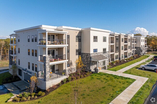

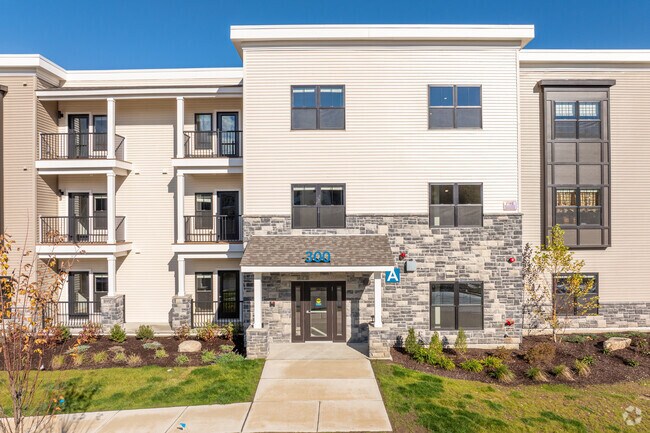
Property Detail
757 Salisbury St
WORC-000050-000023-000001
Worcester
Apartment
Massachusetts
RS-10
1
B and X Area of moderate flood hazard, usually the area between the limits of the 100-year and 500-year floods.
17.36 AC
2025
West Tatnuck
2025
Boston
730700
Worcester, MA
NEARBY LISTINGS FOR SALE OR LEASE
DEMOGRAPHICS near 757 Salisbury St
1 mile
3 mile
5 mile
2025 Total Population
6,699
67,430
206,079
2030 Population
6,844
68,248
208,355
Pop Growth 2025-2030
+ 2.16%
+ 1.21%
+ 1.10%
Average Age
42
40
39
2025 Total Households
2,082
24,832
79,190
HH Growth 2025-2030
+ 2.40%
+ 1.19%
+ 1.17%
Median Household Inc
$124,825
$103,815
$75,674
Avg Household Size
2.50
2.40
2.40
2025 Avg HH Vehicles
2.00
2.00
1.00
Median Home Value
$461,774
$438,837
$403,006
Median Year Built
1980
1953
1951
Nearby Places
Map Layers
Map Styles
 Street
 Aerial
Layers
 Traffic
 Biking
Places
Listings with unknown addresses are not visible on the map
- Restaurants
- Banks
- Shops
- Fitness
- Groceries
PUBLIC TRANSPORTATION
COMMUTER RAIL
Worcester Union Station (Lake Shore Limited - Amtrak)
Drive
Walk
Distance
Worcester Union Station (Lake Shore Limited - Amtrak)
9 min
4.5 mi
Worcester (Framingham/Worcester Line - Massachusetts Bay Transportation Authority Commuter Rail (Purple Line))
Drive
Walk
Distance
Worcester (Framingham/Worcester Line - Massachusetts Bay Transportation Authority Commuter Rail (Purple Line))
9 min
4.7 mi
AIRPORT
Worcester Regional
Drive
Walk
Distance
Worcester Regional
13 min
5.2 mi
Freight Ports
Port of Boston
Drive
Walk
Distance
Port of Boston
69 min
49.5 mi
Nearby Properties
Address
Land Use
TOTAL SIZE
Lot Size
Zoning
Address
Land Use
TOTAL SIZE
Lot Size
Zoning
49.51 AC
IN-S
Address
Land Use
TOTAL SIZE
Lot Size
Zoning
50.11 AC
RS-7
Address
Land Use
TOTAL SIZE
Lot Size
Zoning
3.85 AC
RG-5
Address
Land Use
TOTAL SIZE
Lot Size
Zoning
117,645 SF
3.11 AC
BO-1
Address
Land Use
TOTAL SIZE
Lot Size
Zoning
16,404 SF
10.80 AC
RS-10
Address
Land Use
TOTAL SIZE
Lot Size
Zoning
126,849 SF
15.18 AC
R15
Address
Land Use
TOTAL SIZE
Lot Size
Zoning
291,410 SF
21.73 AC
RL-7
Address
Land Use
TOTAL SIZE
Lot Size
Zoning
44,584 SF
90.22 AC
Address
Land Use
TOTAL SIZE
Lot Size
Zoning
177.12 AC
RL-7
Address
Land Use
TOTAL SIZE
Lot Size
Zoning
175,200 SF
2.26 AC
BL-1
Address
Land Use
TOTAL SIZE
Lot Size
Zoning
286,338 SF
33.45 AC
RL-7
Address
Land Use
TOTAL SIZE
Lot Size
Zoning
120,732 SF
28.92 AC
RS-10
Address
Land Use
TOTAL SIZE
Lot Size
Zoning
121,780 SF
1.39 AC
BG-6
Address
Land Use
TOTAL SIZE
Lot Size
Zoning
188,980 SF
20 AC
RL-7
Address
Land Use
TOTAL SIZE
Lot Size
Zoning
64,709 SF
1.80 AC
RS-10
Address
Land Use
TOTAL SIZE
Lot Size
Zoning
10.70 AC
RS-7
Address
Land Use
TOTAL SIZE
Lot Size
Zoning
153,482 SF
5.95 AC
MG-1
Address
Land Use
TOTAL SIZE
Lot Size
Zoning
145,068 SF
16.35 AC
BG-3
Address
Land Use
TOTAL SIZE
Lot Size
Zoning
121,504 SF
3.75 AC
BG-3
Address
Land Use
TOTAL SIZE
Lot Size
Zoning
741.61 AC
R40
Address
Land Use
TOTAL SIZE
Lot Size
Zoning
11 AC
RS-7
Address
Land Use
TOTAL SIZE
Lot Size
Zoning
96,541 SF
5.24 AC
MG-5
Address
Land Use
TOTAL SIZE
Lot Size
Zoning
137,290 SF
10.51 AC
RS-7
Address
Land Use
TOTAL SIZE
Lot Size
Zoning
11.28 AC
RL-7
Address
Land Use
TOTAL SIZE
Lot Size
Zoning
29.20 AC
RS-7
Address
Land Use
TOTAL SIZE
Lot Size
Zoning
12.23 AC
RS-7
Address
Land Use
TOTAL SIZE
Lot Size
Zoning
235,155 SF
11.61 AC
MG-2
Address
Land Use
TOTAL SIZE
Lot Size
Zoning
2,202 SF
11.79 AC
RS-10
Address
Land Use
TOTAL SIZE
Lot Size
Zoning
1,244 SF
40.52 AC
RL-7
Address
Land Use
TOTAL SIZE
Lot Size
Zoning
75,740 SF
2.06 AC
BG-6
The World's #1 Commercial Real Estate Marketplace
Connect with us
© 2026 CoStar Group
The information above has been obtained from sources believed reliable. While we do not doubt its accuracy we have not verified it and make no guarantee, warranty or representation about it. It is your responsibility to independently confirm its accuracy and completeness. Any projections, opinions, assumptions, or estimates used are for example only and do not represent the current or future performance of the property. The value of this transaction to you depends on tax and other factors which should be evaluated by your tax, financial, and legal advisors. You and your advisors should conduct a careful, independent investigation of the property to determine to your satisfaction the suitability of the property for your needs.