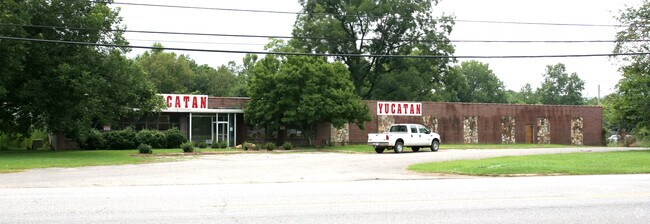
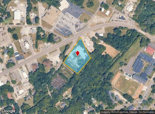
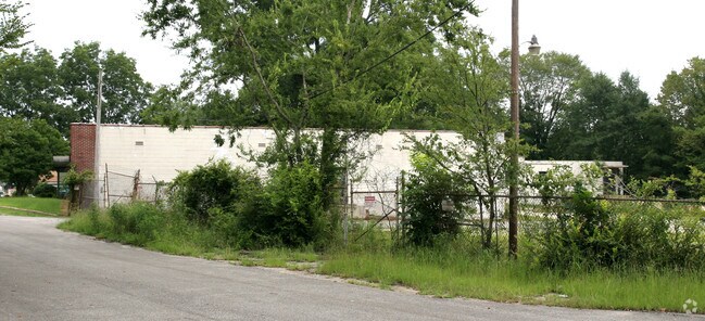
Property Record
7575 Parkway Dr, Leeds, AL 35094
NEARBY LISTINGS FOR SALE OR LEASE
Property Detail
7575 Parkway Dr
25-00-21-2-010-005.000
BEG AT INT OF SE R/W AN UNNAMED PUBLIC RD & S R/W OF PARKWAY DRIVE SE TH ELY ALONG PARKWAY DR 16.5 FT TH SELY 286.5 FT TH SWLY 270 FT TH NWLY 247.5 F T THNELY ALONG SD UNNAMED RD 301.7 FT TH SELY 17 FT TH NELY 96.3 FT TO P O B SEC 21 TP 17 R 1E SECT
Lightindustrial
Jefferson
AE
Alabama
01115C0341H
1.95 AC
2023
Trussville
2024
Birmingham
011003
Birmingham-Hoover, AL
21,543 SF
DEMOGRAPHICS near 7575 Parkway Dr
1 Mile
3 Mile
5 Mile
2024 Total Population
3,749
12,497
26,049
2029 Population
3,717
12,515
26,400
Pop Growth 2024-2029
(0.85%)
+ 0.14%
+ 1.35%
Average Age
39
40
40
2024 Total Households
1,576
5,066
10,208
HH Growth 2024-2029
(0.89%)
+ 0.08%
+ 1.36%
Median Household Inc
$45,060
$60,663
$64,434
Avg Household Size
2.40
2.40
2.50
2024 Avg HH Vehicles
2.00
2.00
2.00
Median Home Value
$128,094
$180,532
$187,603
Median Year Built
1969
1982
1990
Nearby Places
Map Layers
Map Styles
 Street
 Aerial
- Restaurants
- Banks
- Shops
- Fitness
- Groceries
PUBLIC TRANSPORTATION
AIRPORT
Birmingham-Shuttlesworth International
DRIVE
WALK
Distance
Birmingham-Shuttlesworth International
20 min
14.3 mi
Freight Ports
Port of Mobile
DRIVE
WALK
Distance
Port of Mobile
291 min
265.6 mi
Nearby Properties
Address
Land Use
TOTAL SIZE
Lot Size
Zoning
Address
Land Use
TOTAL SIZE
Lot Size
Zoning
356,967 SF
34.71 AC
I3S&
Address
Land Use
TOTAL SIZE
Lot Size
Zoning
146,749 SF
23.99 AC
B2
Address
Land Use
TOTAL SIZE
Lot Size
Zoning
52,828 SF
12.70 AC
B2
Address
Land Use
TOTAL SIZE
Lot Size
Zoning
28,666 SF
4.41 AC
B2
Address
Land Use
TOTAL SIZE
Lot Size
Zoning
15.90 AC
Address
Land Use
TOTAL SIZE
Lot Size
Zoning
123,425 SF
15.80 AC
Address
Land Use
TOTAL SIZE
Lot Size
Zoning
51,801 SF
7.45 AC
Address
Land Use
TOTAL SIZE
Lot Size
Zoning
57,399 SF
2.49 AC
Address
Land Use
TOTAL SIZE
Lot Size
Zoning
59,487 SF
9.20 AC
B2-R
Address
Land Use
TOTAL SIZE
Lot Size
Zoning
46,031 SF
8.30 AC
Address
Land Use
TOTAL SIZE
Lot Size
Zoning
22.57 AC
I3
Address
Land Use
TOTAL SIZE
Lot Size
Zoning
82,025 SF
Address
Land Use
TOTAL SIZE
Lot Size
Zoning
184,068 SF
62 AC
M2
Address
Land Use
TOTAL SIZE
Lot Size
Zoning
243,530 SF
29 AC
M2
Address
Land Use
TOTAL SIZE
Lot Size
Zoning
77,822 SF
6.12 AC
R-3
Address
Land Use
TOTAL SIZE
Lot Size
Zoning
139,086 SF
15 AC
M2
Address
Land Use
TOTAL SIZE
Lot Size
Zoning
6,000 SF
8.30 AC
Address
Land Use
TOTAL SIZE
Lot Size
Zoning
29,580 SF
5.74 AC
Address
Land Use
TOTAL SIZE
Lot Size
Zoning
122,300 SF
5.70 AC
M2-I
Address
Land Use
TOTAL SIZE
Lot Size
Zoning
80,643 SF
4.22 AC
R3
Address
Land Use
TOTAL SIZE
Lot Size
Zoning
82,256 SF
6.60 AC
B-2
Address
Land Use
TOTAL SIZE
Lot Size
Zoning
12,960 SF
4.45 AC
B2
Address
Land Use
TOTAL SIZE
Lot Size
Zoning
113,550 SF
10 AC
M-2
Address
Land Use
TOTAL SIZE
Lot Size
Zoning
14.18 AC
B2
Address
Land Use
TOTAL SIZE
Lot Size
Zoning
141,610 SF
4.40 AC
M1-R
Address
Land Use
TOTAL SIZE
Lot Size
Zoning
6.66 AC
Address
Land Use
TOTAL SIZE
Lot Size
Zoning
35,483 SF
1.39 AC
The World's #1 Commercial Real Estate Marketplace
Connect with us
© 2025 CoStar Group
The information above has been obtained from sources believed reliable. While we do not doubt its accuracy we have not verified it and make no guarantee, warranty or representation about it. It is your responsibility to independently confirm its accuracy and completeness. Any projections, opinions, assumptions, or estimates used are for example only and do not represent the current or future performance of the property. The value of this transaction to you depends on tax and other factors which should be evaluated by your tax, financial, and legal advisors. You and your advisors should conduct a careful, independent investigation of the property to determine to your satisfaction the suitability of the property for your needs.