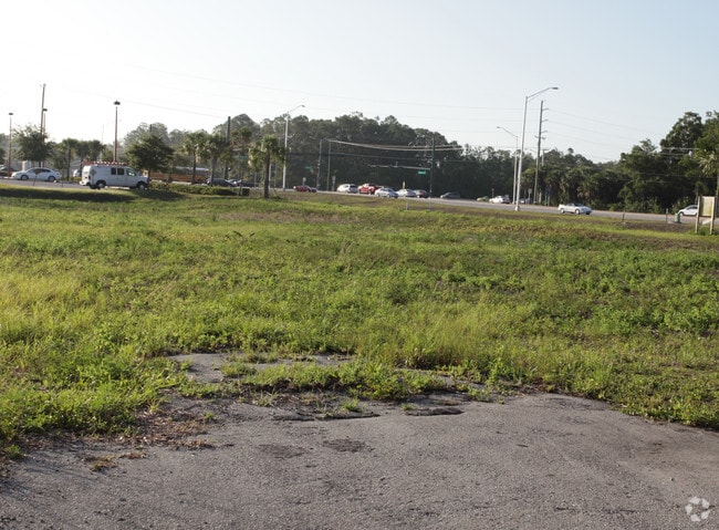
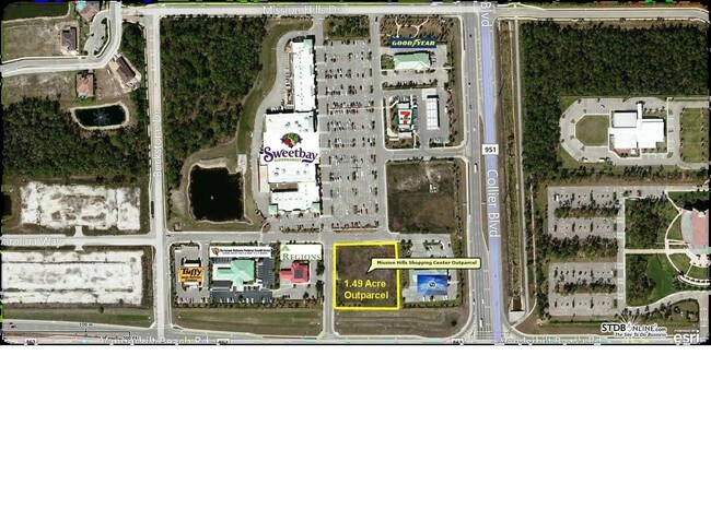
Property Record
7575 Vanderbilt Beach Rd, Naples, FL 34119

Property Detail
7575 Vanderbilt Beach Rd
60204200484
MISSION HILLS SHOPPING CENTER TRACT 8
Storemultistory
Collier
PUD
Florida
C and X Area of minimal flood hazard, usually depicted on FIRMs as above the 500-year flood level.
1
2024
1.49 AC
2025
North Naples
010416
Southwest Florida
6,939 SF
Naples-Marco Island, FL
NEARBY LISTINGS FOR SALE OR LEASE
DEMOGRAPHICS near 7575 Vanderbilt Beach Rd
1 mile
3 mile
5 mile
2025 Total Population
6,295
35,878
100,388
2030 Population
6,710
38,296
106,559
Pop Growth 2025-2030
+ 6.59%
+ 6.74%
+ 6.15%
Average Age
43
45
45
2025 Total Households
2,266
13,630
38,717
HH Growth 2025-2030
+ 6.27%
+ 6.09%
+ 5.74%
Median Household Inc
$91,254
$104,242
$95,756
Avg Household Size
2.60
2.50
2.50
2025 Avg HH Vehicles
2.00
2.00
2.00
Median Home Value
$610,819
$673,988
$639,684
Median Year Built
2005
2004
2001
Nearby Places
Map Layers
Map Styles
 Street
 Aerial
Layers
 Traffic
 Biking
Places
Listings with unknown addresses are not visible on the map
- Restaurants
- Banks
- Shops
- Fitness
- Groceries
PUBLIC TRANSPORTATION
AIRPORT
Southwest Florida International
Drive
Walk
Distance
Southwest Florida International
39 min
27.9 mi
Nearby Properties
Address
Land Use
TOTAL SIZE
Lot Size
Zoning
Address
Land Use
TOTAL SIZE
Lot Size
Zoning
465,208 SF
17.72 AC
Address
Land Use
TOTAL SIZE
Lot Size
Zoning
463,985 SF
28.48 AC
Address
Land Use
TOTAL SIZE
Lot Size
Zoning
312,140 SF
15 AC
Address
Land Use
TOTAL SIZE
Lot Size
Zoning
275,219 SF
16.20 AC
Address
Land Use
TOTAL SIZE
Lot Size
Zoning
376,493 SF
65.03 AC
RSF-3
Address
Land Use
TOTAL SIZE
Lot Size
Zoning
52,982 SF
10.58 AC
Address
Land Use
TOTAL SIZE
Lot Size
Zoning
142,737 SF
37.48 AC
A
Address
Land Use
TOTAL SIZE
Lot Size
Zoning
41,465 SF
3.36 AC
PUD
Address
Land Use
TOTAL SIZE
Lot Size
Zoning
115,552 SF
13.20 AC
PUD
Address
Land Use
TOTAL SIZE
Lot Size
Zoning
104,470 SF
13.06 AC
PUD
Address
Land Use
TOTAL SIZE
Lot Size
Zoning
22,099 SF
7.73 AC
PUD
Address
Land Use
TOTAL SIZE
Lot Size
Zoning
113,867 SF
6.90 AC
PUD
Address
Land Use
TOTAL SIZE
Lot Size
Zoning
86,254 SF
18.57 AC
A
Address
Land Use
TOTAL SIZE
Lot Size
Zoning
52,370 SF
7.82 AC
PUD
Address
Land Use
TOTAL SIZE
Lot Size
Zoning
54,140 SF
50.66 AC
PUD
Address
Land Use
TOTAL SIZE
Lot Size
Zoning
46,820 SF
7.02 AC
PUD
Address
Land Use
TOTAL SIZE
Lot Size
Zoning
39,728 SF
5.74 AC
Address
Land Use
TOTAL SIZE
Lot Size
Zoning
61,688 SF
2.65 AC
Address
Land Use
TOTAL SIZE
Lot Size
Zoning
40,045 SF
35.33 AC
A-MHO
Address
Land Use
TOTAL SIZE
Lot Size
Zoning
59,616 SF
2.51 AC
Address
Land Use
TOTAL SIZE
Lot Size
Zoning
98,809 SF
18 AC
PUD
Address
Land Use
TOTAL SIZE
Lot Size
Zoning
56,819 SF
13.52 AC
E
Address
Land Use
TOTAL SIZE
Lot Size
Zoning
84,474 SF
18.16 AC
PUD
Address
Land Use
TOTAL SIZE
Lot Size
Zoning
35,947 SF
17.33 AC
A
Address
Land Use
TOTAL SIZE
Lot Size
Zoning
80,145 SF
9.30 AC
PUD
Address
Land Use
TOTAL SIZE
Lot Size
Zoning
110,133 SF
2.30 AC
Address
Land Use
TOTAL SIZE
Lot Size
Zoning
92,070 SF
2.37 AC
Address
Land Use
TOTAL SIZE
Lot Size
Zoning
104,640 SF
1.82 AC
Address
Land Use
TOTAL SIZE
Lot Size
Zoning
78,454 SF
19.27 AC
E
Address
Land Use
TOTAL SIZE
Lot Size
Zoning
87,843 SF
21.47 AC
PUD
The World's #1 Commercial Real Estate Marketplace
Connect with us
© 2026 CoStar Group
The information above has been obtained from sources believed reliable. While we do not doubt its accuracy we have not verified it and make no guarantee, warranty or representation about it. It is your responsibility to independently confirm its accuracy and completeness. Any projections, opinions, assumptions, or estimates used are for example only and do not represent the current or future performance of the property. The value of this transaction to you depends on tax and other factors which should be evaluated by your tax, financial, and legal advisors. You and your advisors should conduct a careful, independent investigation of the property to determine to your satisfaction the suitability of the property for your needs.