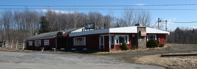
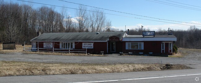
Property Record
7576 State Route 13, Blossvale, NY 13308

Property Detail
7576 State Route 13
Utica-Rome, NY
7576ST RD13300X300X275 N 3900 E 3950 S 3880 W RD 13
217-000-0002-023-000-0000
ONEIDA
Gasolinefuelbulkstorage
New York
C
23.000
A Areas with a 1% annual chance of flooding and a 26% chance of flooding over the life of a 30-year mortgage.
5.14 AC
2025
Outlying Oneida County
2025
Utica/Rome
026700
NEARBY LISTINGS FOR SALE OR LEASE
DEMOGRAPHICS near 7576 State Route 13
1 mile
3 mile
5 mile
2025 Total Population
421
3,042
5,835
2030 Population
434
3,067
5,891
Pop Growth 2025-2030
+ 3.09%
+ 0.82%
+ 0.96%
Average Age
48
46
46
2025 Total Households
198
1,348
2,494
HH Growth 2025-2030
+ 3.03%
+ 0.74%
+ 0.88%
Median Household Inc
$103,220
$72,077
$77,059
Avg Household Size
2.10
2.20
2.30
2025 Avg HH Vehicles
2.00
2.00
2.00
Median Home Value
$308,696
$165,877
$164,545
Median Year Built
1956
1964
1964
Nearby Places
Map Layers
Map Styles
 Street
 Aerial
Layers
 Traffic
 Biking
Places
Listings with unknown addresses are not visible on the map
- Restaurants
- Banks
- Shops
- Fitness
- Groceries
PUBLIC TRANSPORTATION
AIRPORT
Syracuse Hancock International
Drive
Walk
Distance
Syracuse Hancock International
47 min
28.9 mi
Freight Ports
Albany, NY Port
Drive
Walk
Distance
Albany, NY Port
155 min
127.4 mi
Nearby Properties
Address
Land Use
TOTAL SIZE
Lot Size
Zoning
Address
Land Use
TOTAL SIZE
Lot Size
Zoning
24,404 SF
0.28 AC
N-2C
Address
Land Use
TOTAL SIZE
Lot Size
Zoning
4,000 SF
4.10 AC
01 - NOT Z
Address
Land Use
TOTAL SIZE
Lot Size
Zoning
13,740 SF
10.40 AC
01 - NOT Z
Address
Land Use
TOTAL SIZE
Lot Size
Zoning
5,692 SF
17.70 AC
V
Address
Land Use
TOTAL SIZE
Lot Size
Zoning
12,988 SF
V
Address
Land Use
TOTAL SIZE
Lot Size
Zoning
1,440 SF
77.40 AC
H
Address
Land Use
TOTAL SIZE
Lot Size
Zoning
17,583 SF
0.50 AC
V
Address
Land Use
TOTAL SIZE
Lot Size
Zoning
Address
Land Use
TOTAL SIZE
Lot Size
Zoning
6,440 SF
1.81 AC
V
Address
Land Use
TOTAL SIZE
Lot Size
Zoning
Address
Land Use
TOTAL SIZE
Lot Size
Zoning
1,215 SF
3.61 AC
V
Address
Land Use
TOTAL SIZE
Lot Size
Zoning
5,000 SF
28.31 AC
C
Address
Land Use
TOTAL SIZE
Lot Size
Zoning
7,004 SF
13.63 AC
01 - NOT Z
Address
Land Use
TOTAL SIZE
Lot Size
Zoning
10,732 SF
1.50 AC
V
Address
Land Use
TOTAL SIZE
Lot Size
Zoning
864 SF
44.45 AC
WR
Address
Land Use
TOTAL SIZE
Lot Size
Zoning
400 SF
19.50 AC
WR
Address
Land Use
TOTAL SIZE
Lot Size
Zoning
1,155 SF
3 AC
V
Address
Land Use
TOTAL SIZE
Lot Size
Zoning
2,500 SF
2.98 AC
C
Address
Land Use
TOTAL SIZE
Lot Size
Zoning
4,960 SF
6.50 AC
V
Address
Land Use
TOTAL SIZE
Lot Size
Zoning
4.20 AC
V
Address
Land Use
TOTAL SIZE
Lot Size
Zoning
3.50 AC
V
Address
Land Use
TOTAL SIZE
Lot Size
Zoning
10,000 SF
127.12 AC
C
Address
Land Use
TOTAL SIZE
Lot Size
Zoning
0.59 AC
V
Address
Land Use
TOTAL SIZE
Lot Size
Zoning
4,080 SF
4.70 AC
V
Address
Land Use
TOTAL SIZE
Lot Size
Zoning
7,538 SF
0.91 AC
V
Address
Land Use
TOTAL SIZE
Lot Size
Zoning
13,236 SF
V
Address
Land Use
TOTAL SIZE
Lot Size
Zoning
9,204 SF
0.94 AC
V
Address
Land Use
TOTAL SIZE
Lot Size
Zoning
7,400 SF
4.01 AC
C
Address
Land Use
TOTAL SIZE
Lot Size
Zoning
0.01 AC
C
Address
Land Use
TOTAL SIZE
Lot Size
Zoning
6,906 SF
0.69 AC
V
The World's #1 Commercial Real Estate Marketplace
Connect with us
© 2026 CoStar Group
The information above has been obtained from sources believed reliable. While we do not doubt its accuracy we have not verified it and make no guarantee, warranty or representation about it. It is your responsibility to independently confirm its accuracy and completeness. Any projections, opinions, assumptions, or estimates used are for example only and do not represent the current or future performance of the property. The value of this transaction to you depends on tax and other factors which should be evaluated by your tax, financial, and legal advisors. You and your advisors should conduct a careful, independent investigation of the property to determine to your satisfaction the suitability of the property for your needs.