Property Record
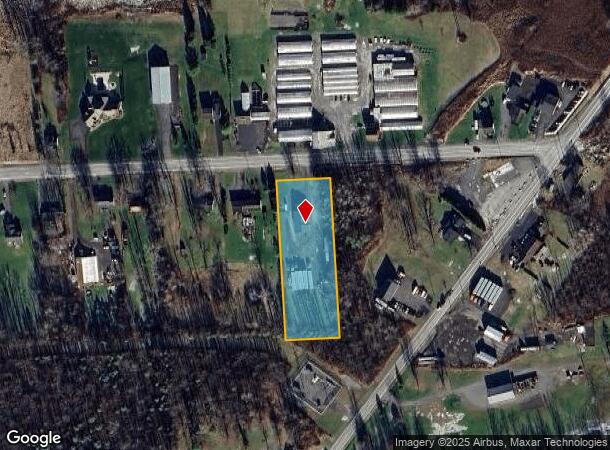
7580 E Taft Rd, East Syracuse, NY 13057
NEARBY LISTINGS FOR SALE OR LEASE
Property Detail
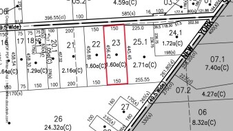
7580 E Taft Rd
312289-064-000-0002-023-000-0000
FL 100 1138332
Miscresidentialimprovement
Onondaga
X
New York
36067C0232F
23.000
2025
1.60 AC
2024
Other Market Areas
010400
Syracuse, NY
DEMOGRAPHICS near 7580 E Taft Rd
1 Mile
3 Mile
5 Mile
2024 Total Population
306
5,254
22,841
2029 Population
305
5,228
22,856
Pop Growth 2024-2029
(0.33%)
(0.49%)
+ 0.07%
Average Age
44
43
43
2024 Total Households
115
2,095
9,404
HH Growth 2024-2029
0.00%
(0.53%)
+ 0.05%
Median Household Inc
$49,999
$55,485
$59,525
Avg Household Size
2.50
2.50
2.40
2024 Avg HH Vehicles
2.00
2.00
2.00
Median Home Value
$125,000
$130,534
$144,523
Median Year Built
1962
1965
1966
Nearby Places
- Restaurants
- Banks
- Shops
- Fitness
- Groceries
PUBLIC TRANSPORTATION
AIRPORT
Syracuse Hancock International
DRIVE
WALK
Distance
Syracuse Hancock International
16 min
9.1 mi
Freight Ports
Albany, NY Port
DRIVE
WALK
Distance
Albany, NY Port
171 min
137.9 mi
Nearby Properties
Address
Land Use
TOTAL SIZE
Lot Size
Zoning
Address
Land Use
TOTAL SIZE
Lot Size
Zoning
80,845 SF
14.04 AC
06 - INDUS
Address
Land Use
TOTAL SIZE
Lot Size
Zoning
5.39 AC
06 - INDUS
Address
Land Use
TOTAL SIZE
Lot Size
Zoning
69,910 SF
16.01 AC
06 - INDUS
Address
Land Use
TOTAL SIZE
Lot Size
Zoning
49,160 SF
7.23 AC
06 - INDUS
Address
Land Use
TOTAL SIZE
Lot Size
Zoning
37.36 AC
RA
Address
Land Use
TOTAL SIZE
Lot Size
Zoning
33.18 AC
C
Address
Land Use
TOTAL SIZE
Lot Size
Zoning
70,364 SF
92.06 AC
AG
Address
Land Use
TOTAL SIZE
Lot Size
Zoning
23.21 AC
C
Address
Land Use
TOTAL SIZE
Lot Size
Zoning
54,386 SF
9.45 AC
C
Address
Land Use
TOTAL SIZE
Lot Size
Zoning
20.28 AC
C
Address
Land Use
TOTAL SIZE
Lot Size
Zoning
38.54 AC
CB
Address
Land Use
TOTAL SIZE
Lot Size
Zoning
32,940 SF
4.78 AC
R4
Address
Land Use
TOTAL SIZE
Lot Size
Zoning
79,216 SF
27.95 AC
06 - INDUS
Address
Land Use
TOTAL SIZE
Lot Size
Zoning
21,595 SF
92.88 AC
RA
Address
Land Use
TOTAL SIZE
Lot Size
Zoning
5,256 SF
5.56 AC
Address
Land Use
TOTAL SIZE
Lot Size
Zoning
24,997 SF
6.84 AC
06 - INDUS
Address
Land Use
TOTAL SIZE
Lot Size
Zoning
16,890 SF
2.07 AC
Address
Land Use
TOTAL SIZE
Lot Size
Zoning
6,794 SF
79.10 AC
RA
Address
Land Use
TOTAL SIZE
Lot Size
Zoning
700 SF
45.42 AC
04
Address
Land Use
TOTAL SIZE
Lot Size
Zoning
92.61 AC
06 - INDUS
Address
Land Use
TOTAL SIZE
Lot Size
Zoning
22,586 SF
34.20 AC
B
Address
Land Use
TOTAL SIZE
Lot Size
Zoning
5,507 SF
1.26 AC
A
Address
Land Use
TOTAL SIZE
Lot Size
Zoning
6,093 SF
271.33 AC
Address
Land Use
TOTAL SIZE
Lot Size
Zoning
22,374 SF
21.98 AC
06 - INDUS
Address
Land Use
TOTAL SIZE
Lot Size
Zoning
6.71 AC
CA
Address
Land Use
TOTAL SIZE
Lot Size
Zoning
4,850 SF
1.73 AC
Address
Land Use
TOTAL SIZE
Lot Size
Zoning
1,436 SF
3.20 AC
Address
Land Use
TOTAL SIZE
Lot Size
Zoning
9,648 SF
13.23 AC
CA
Address
Land Use
TOTAL SIZE
Lot Size
Zoning
3,008 SF
131.14 AC
RA
Address
Land Use
TOTAL SIZE
Lot Size
Zoning
8,400 SF
5.26 AC
BUS
The World's #1 Commercial Real Estate Marketplace
Connect with us
© 2025 CoStar Group
The information above has been obtained from sources believed reliable. While we do not doubt its accuracy we have not verified it and make no guarantee, warranty or representation about it. It is your responsibility to independently confirm its accuracy and completeness. Any projections, opinions, assumptions, or estimates used are for example only and do not represent the current or future performance of the property. The value of this transaction to you depends on tax and other factors which should be evaluated by your tax, financial, and legal advisors. You and your advisors should conduct a careful, independent investigation of the property to determine to your satisfaction the suitability of the property for your needs.