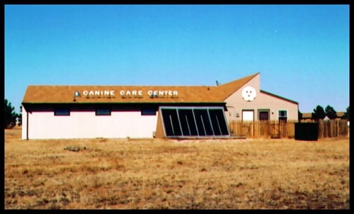
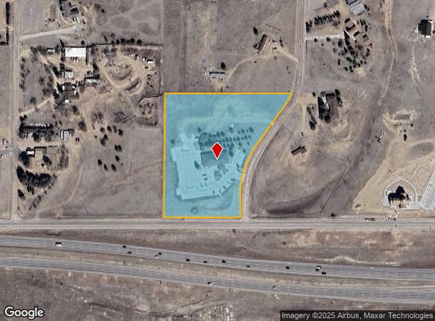
Property Record
7580 Ponca Rd, Colorado Springs, CO 80908
NEARBY LISTINGS FOR SALE OR LEASE
-
-
-
7452 Solace Forest View, Colorado Spgs
Colorado Springs, CO 80927
Rent Upon Request
1.58 AC Lots
Land
-
-
NEC E. Woodmen Rd. & Marksheffel rd
Colorado Springs, CO 80908
$1,050,000 - $3,550,000
1.28 - 3.13 AC Lot
Land
-
-
-
View all Colorado Springs listings for sale on LoopNet.com
Property Detail
7580 Ponca Rd
Colorado Springs, CO
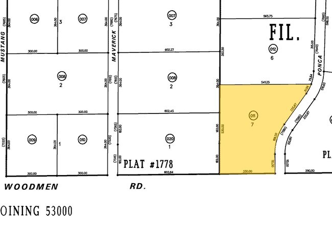
Pawnee Rancheros Fil No 1
53040-03-011
LOT 7 BLK 1 PAWNEE RANCHEROS FIL 1 SUBJ TO 16.0 FT EASEMENT + R/W TO MT STATES TELEPHONE + TELEGRAPH CO DES BK 2880-123
Religious
El Paso
X
Colorado
08041C0533G
7
0
4.81 AC
2025
Northeast
007603
Colorado Springs
6,498 SF
DEMOGRAPHICS near 7580 Ponca Rd
1 Mile
3 Mile
5 Mile
2024 Total Population
6,417
48,136
150,583
2029 Population
7,017
51,290
158,461
Pop Growth 2024-2029
+ 9.35%
+ 6.55%
+ 5.23%
Average Age
33
35
36
2024 Total Households
2,055
16,080
52,360
HH Growth 2024-2029
+ 9.49%
+ 6.72%
+ 5.39%
Median Household Inc
$117,771
$108,818
$105,805
Avg Household Size
3.10
3.00
2.80
2024 Avg HH Vehicles
2.00
2.00
2.00
Median Home Value
$469,529
$445,952
$422,669
Median Year Built
2011
2010
2005
Nearby Places
Map Layers
Map Styles
 Street
 Aerial
- Restaurants
- Banks
- Shops
- Fitness
- Groceries
PUBLIC TRANSPORTATION
AIRPORT
City of Colorado Springs Municipal
DRIVE
WALK
Distance
City of Colorado Springs Municipal
20 min
11.0 mi
Freight Ports
Tulsa Port Of Catoosa
DRIVE
WALK
Distance
Tulsa Port Of Catoosa
722 min
682.5 mi
Nearby Properties
Address
Land Use
TOTAL SIZE
Lot Size
Zoning
Address
Land Use
TOTAL SIZE
Lot Size
Zoning
1,129,761 SF
32.88 AC
MX-M HR AO
Address
Land Use
TOTAL SIZE
Lot Size
Zoning
356,093 SF
16.27 AC
R-5 AO SS
Address
Land Use
TOTAL SIZE
Lot Size
Zoning
262,950 SF
13.23 AC
PDZ AO
Address
Land Use
TOTAL SIZE
Lot Size
Zoning
80,503 SF
14.36 AC
PDZ AO
Address
Land Use
TOTAL SIZE
Lot Size
Zoning
35,197 SF
8.38 AC
PDZ AO
Address
Land Use
TOTAL SIZE
Lot Size
Zoning
58,630 SF
17.84 AC
A-5 CAD-O
Address
Land Use
TOTAL SIZE
Lot Size
Zoning
Address
Land Use
TOTAL SIZE
Lot Size
Zoning
44,844 SF
21.84 AC
PDZ AO
Address
Land Use
TOTAL SIZE
Lot Size
Zoning
48,363 SF
5.60 AC
A AO SS
Address
Land Use
TOTAL SIZE
Lot Size
Zoning
116,367 SF
0.09 AC
Address
Land Use
TOTAL SIZE
Lot Size
Zoning
408,505 SF
20.39 AC
MX-M AO
Address
Land Use
TOTAL SIZE
Lot Size
Zoning
27,950 SF
17.19 AC
MX-M AO
Address
Land Use
TOTAL SIZE
Lot Size
Zoning
352,714 SF
22.77 AC
PDZ AO
Address
Land Use
TOTAL SIZE
Lot Size
Zoning
83,825 SF
5.16 AC
MX-M HR AO
Address
Land Use
TOTAL SIZE
Lot Size
Zoning
329,040 SF
19.99 AC
PDZ AO
Address
Land Use
TOTAL SIZE
Lot Size
Zoning
76,727 SF
2.71 AC
PBC HR AO
Address
Land Use
TOTAL SIZE
Lot Size
Zoning
89,482 SF
10.85 AC
MX-M/CR AO
Address
Land Use
TOTAL SIZE
Lot Size
Zoning
69,546 SF
7 AC
MX-M AO
Address
Land Use
TOTAL SIZE
Lot Size
Zoning
304,846 SF
11.14 AC
MX-L/CR AO
Address
Land Use
TOTAL SIZE
Lot Size
Zoning
195,448 SF
19.86 AC
CR
Address
Land Use
TOTAL SIZE
Lot Size
Zoning
22,550 SF
2.05 AC
MX-M AO
Address
Land Use
TOTAL SIZE
Lot Size
Zoning
63,170 SF
3.91 AC
MX-M AO
Address
Land Use
TOTAL SIZE
Lot Size
Zoning
11,998 SF
3.66 AC
RR-5 CAD-O
Address
Land Use
TOTAL SIZE
Lot Size
Zoning
15,747 SF
4.29 AC
RR-5 CAD-O
Address
Land Use
TOTAL SIZE
Lot Size
Zoning
48.62 AC
PDZ AO
Address
Land Use
TOTAL SIZE
Lot Size
Zoning
16,529 SF
5.76 AC
OR AO
Address
Land Use
TOTAL SIZE
Lot Size
Zoning
36,097 SF
10 AC
RR-5 CAD-O
Address
Land Use
TOTAL SIZE
Lot Size
Zoning
3,736 SF
15.43 AC
A-5 CAD-O
Address
Land Use
TOTAL SIZE
Lot Size
Zoning
95,365 SF
12 AC
MX-L/CR AO
Address
Land Use
TOTAL SIZE
Lot Size
Zoning
44,844 SF
21.85 AC
PUD
The World's #1 Commercial Real Estate Marketplace
Connect with us
© 2025 CoStar Group
The information above has been obtained from sources believed reliable. While we do not doubt its accuracy we have not verified it and make no guarantee, warranty or representation about it. It is your responsibility to independently confirm its accuracy and completeness. Any projections, opinions, assumptions, or estimates used are for example only and do not represent the current or future performance of the property. The value of this transaction to you depends on tax and other factors which should be evaluated by your tax, financial, and legal advisors. You and your advisors should conduct a careful, independent investigation of the property to determine to your satisfaction the suitability of the property for your needs.