Property Record
759 E 400 S, Springville, UT 84663
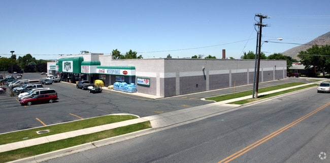


Property Detail
759 E 400 S
Provo-Orem-Lehi, UT
COM N 610.51 FT & E 2.14 FT FR SW COR SEC 34, T7S, R3E, SLM; S 89 DEG 4033E 505.46 FT; N 3340E 307.06 FT; W 304.47 FT; S 1 DEG 0543E 139.62 FT; N 89 DEG 3521W 206.66 FT; S 166.07 FT TO BEG. AREA 2.90 ACRES.
23-045-0006
Utah
Supermarket
Utah
2024
2.90 AC
2025
Utah County
003105
Salt Lake City
45,230 SF
NEARBY LISTINGS FOR SALE OR LEASE
DEMOGRAPHICS near 759 E 400 S
1 mile
3 mile
5 mile
2025 Total Population
14,586
50,250
95,642
2030 Population
15,742
55,344
105,292
Pop Growth 2025-2030
+ 7.93%
+ 10.14%
+ 10.09%
Average Age
34
33
33
2025 Total Households
4,523
14,271
27,171
HH Growth 2025-2030
+ 8.67%
+ 10.71%
+ 10.77%
Median Household Inc
$86,008
$102,574
$99,735
Avg Household Size
3.20
3.50
3.50
2025 Avg HH Vehicles
2.00
2.00
2.00
Median Home Value
$484,924
$555,385
$531,236
Median Year Built
1975
1999
1999
Nearby Places
Map Layers
Map Styles
 Street
 Aerial
Transit
 Traffic
 Biking
Places
Listings with unknown addresses are not visible on the map
- Restaurants
- Banks
- Shops
- Fitness
- Groceries
PUBLIC TRANSPORTATION
COMMUTER RAIL
Provo Central Station (FrontRunner - Utah Transit Authority (UTA))
Drive
Walk
Distance
Provo Central Station (FrontRunner - Utah Transit Authority (UTA))
11 min
7.5 mi
Provo Amtrak (California Zephyr - Amtrak)
Drive
Walk
Distance
Provo Amtrak (California Zephyr - Amtrak)
12 min
7.5 mi
AIRPORT
Provo Municipal
Drive
Walk
Distance
Provo Municipal
15 min
9.5 mi
Freight Ports
Port of Stockton
Drive
Walk
Distance
Port of Stockton
764 min
746.1 mi
Nearby Properties
Address
Land Use
TOTAL SIZE
Lot Size
Zoning
Address
Land Use
TOTAL SIZE
Lot Size
Zoning
69,236 SF
30.28 AC
Address
Land Use
TOTAL SIZE
Lot Size
Zoning
286,188 SF
13.63 AC
Address
Land Use
TOTAL SIZE
Lot Size
Zoning
269,742 SF
16.30 AC
Address
Land Use
TOTAL SIZE
Lot Size
Zoning
671,002 SF
59.02 AC
Address
Land Use
TOTAL SIZE
Lot Size
Zoning
370,735 SF
18.54 AC
Address
Land Use
TOTAL SIZE
Lot Size
Zoning
301,852 SF
20.24 AC
Address
Land Use
TOTAL SIZE
Lot Size
Zoning
170,774 SF
9.70 AC
Address
Land Use
TOTAL SIZE
Lot Size
Zoning
177,428 SF
9.83 AC
Address
Land Use
TOTAL SIZE
Lot Size
Zoning
210,644 SF
19.55 AC
Address
Land Use
TOTAL SIZE
Lot Size
Zoning
125,729 SF
12.84 AC
Address
Land Use
TOTAL SIZE
Lot Size
Zoning
240,674 SF
19.41 AC
Address
Land Use
TOTAL SIZE
Lot Size
Zoning
238,651 SF
14.45 AC
Address
Land Use
TOTAL SIZE
Lot Size
Zoning
151,447 SF
16.14 AC
Address
Land Use
TOTAL SIZE
Lot Size
Zoning
141,566 SF
7.89 AC
Address
Land Use
TOTAL SIZE
Lot Size
Zoning
231,991 SF
13.76 AC
Address
Land Use
TOTAL SIZE
Lot Size
Zoning
79,260 SF
5.24 AC
Address
Land Use
TOTAL SIZE
Lot Size
Zoning
151,447 SF
8.61 AC
Address
Land Use
TOTAL SIZE
Lot Size
Zoning
124,255 SF
9.87 AC
Address
Land Use
TOTAL SIZE
Lot Size
Zoning
128,650 SF
10 AC
Address
Land Use
TOTAL SIZE
Lot Size
Zoning
120,613 SF
5.13 AC
Address
Land Use
TOTAL SIZE
Lot Size
Zoning
170,273 SF
9.19 AC
Address
Land Use
TOTAL SIZE
Lot Size
Zoning
136,548 SF
7.67 AC
Address
Land Use
TOTAL SIZE
Lot Size
Zoning
100,937 SF
6.71 AC
Address
Land Use
TOTAL SIZE
Lot Size
Zoning
112,709 SF
8.10 AC
Address
Land Use
TOTAL SIZE
Lot Size
Zoning
155,605 SF
18.90 AC
Address
Land Use
TOTAL SIZE
Lot Size
Zoning
72,453 SF
14.17 AC
Address
Land Use
TOTAL SIZE
Lot Size
Zoning
92,788 SF
5.53 AC
Address
Land Use
TOTAL SIZE
Lot Size
Zoning
113,013 SF
5.89 AC
Address
Land Use
TOTAL SIZE
Lot Size
Zoning
96,879 SF
7.91 AC
Address
Land Use
TOTAL SIZE
Lot Size
Zoning
82,610 SF
2.46 AC
The World's #1 Commercial Real Estate Marketplace
Connect with us
© 2026 CoStar Group
The information above has been obtained from sources believed reliable. While we do not doubt its accuracy we have not verified it and make no guarantee, warranty or representation about it. It is your responsibility to independently confirm its accuracy and completeness. Any projections, opinions, assumptions, or estimates used are for example only and do not represent the current or future performance of the property. The value of this transaction to you depends on tax and other factors which should be evaluated by your tax, financial, and legal advisors. You and your advisors should conduct a careful, independent investigation of the property to determine to your satisfaction the suitability of the property for your needs.