Property Record
7592 Melton Rd, Gary, IN 46403
NEARBY LISTINGS FOR SALE OR LEASE
-
-
View all Gary listings for sale on LoopNet.com
Property Detail
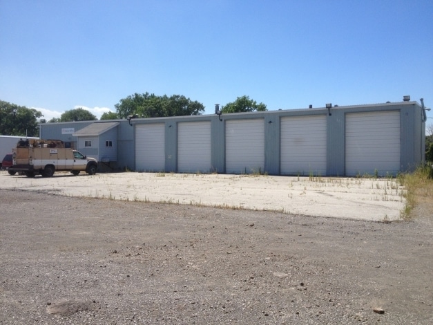
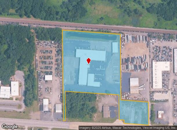
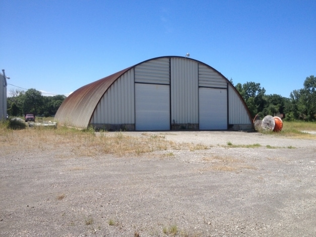
7592 Melton Rd
45-09-05-476-001.000-004
PT OF SE1/4 BTWN R.R. & U.S. HWY 20 S.5 T.36 R.7 9.957 AC
Warehouse
Lake
X
Indiana
18089C0176F
1
2024
9.96 AC
2025
Indiana
010207
Chicago
62,714 SF
Chicago-Naperville-Elgin, IL-IN-WI
DEMOGRAPHICS near 7592 Melton Rd
1 Mile
3 Mile
5 Mile
2024 Total Population
2,704
32,824
92,059
2029 Population
2,755
33,301
93,898
Pop Growth 2024-2029
+ 1.89%
+ 1.45%
+ 2.00%
Average Age
37
40
40
2024 Total Households
1,181
13,373
37,184
HH Growth 2024-2029
+ 1.86%
+ 1.56%
+ 2.07%
Median Household Inc
$35,158
$48,552
$49,997
Avg Household Size
2.30
2.40
2.40
2024 Avg HH Vehicles
1.00
2.00
2.00
Median Home Value
$93,384
$142,742
$158,661
Median Year Built
1966
1961
1967
Nearby Places
Map Layers
Map Styles
 Street
 Aerial
- Restaurants
- Banks
- Shops
- Fitness
- Groceries
PUBLIC TRANSPORTATION
COMMUTER RAIL
Miller (Gary) Station (South Shore Line - Northern Indiana Commuter Transportation District (South Shore Line))
DRIVE
WALK
Distance
Miller (Gary) Station (South Shore Line - Northern Indiana Commuter Transportation District (South Shore Line))
4 min
1.5 mi
Ogden Dunes (Portage) Station (South Shore Line - Northern Indiana Commuter Transportation District (South Shore Line))
DRIVE
WALK
Distance
Ogden Dunes (Portage) Station (South Shore Line - Northern Indiana Commuter Transportation District (South Shore Line))
8 min
4.3 mi
AIRPORT
Chicago Midway International
DRIVE
WALK
Distance
Chicago Midway International
54 min
34.9 mi
Freight Ports
Port Milwaukee
DRIVE
WALK
Distance
Port Milwaukee
154 min
120.2 mi
Nearby Properties
Address
Land Use
TOTAL SIZE
Lot Size
Zoning
Address
Land Use
TOTAL SIZE
Lot Size
Zoning
33,035 SF
2.93 AC
Address
Land Use
TOTAL SIZE
Lot Size
Zoning
164,916 SF
R33
Address
Land Use
TOTAL SIZE
Lot Size
Zoning
59,580 SF
9.55 AC
Address
Land Use
TOTAL SIZE
Lot Size
Zoning
6,356 SF
454.89 AC
Address
Land Use
TOTAL SIZE
Lot Size
Zoning
198,129 SF
81.48 AC
Address
Land Use
TOTAL SIZE
Lot Size
Zoning
48,955 SF
14.50 AC
Address
Land Use
TOTAL SIZE
Lot Size
Zoning
124,160 SF
87 SF
Address
Land Use
TOTAL SIZE
Lot Size
Zoning
31,884 SF
23.22 AC
Address
Land Use
TOTAL SIZE
Lot Size
Zoning
37,351 SF
13.74 AC
Address
Land Use
TOTAL SIZE
Lot Size
Zoning
247,594 SF
15.35 AC
Address
Land Use
TOTAL SIZE
Lot Size
Zoning
230,260 SF
44 SF
Address
Land Use
TOTAL SIZE
Lot Size
Zoning
236,684 SF
9.10 AC
Address
Land Use
TOTAL SIZE
Lot Size
Zoning
6,880 SF
6.71 AC
Address
Land Use
TOTAL SIZE
Lot Size
Zoning
Address
Land Use
TOTAL SIZE
Lot Size
Zoning
4,676 SF
4.91 AC
Address
Land Use
TOTAL SIZE
Lot Size
Zoning
14,306 SF
1.78 AC
Address
Land Use
TOTAL SIZE
Lot Size
Zoning
91,104 SF
8.35 AC
1908
Address
Land Use
TOTAL SIZE
Lot Size
Zoning
16,808 SF
1.12 AC
Address
Land Use
TOTAL SIZE
Lot Size
Zoning
4,980 SF
5.05 AC
Address
Land Use
TOTAL SIZE
Lot Size
Zoning
26,056 SF
1.13 AC
R33
Address
Land Use
TOTAL SIZE
Lot Size
Zoning
153,600 SF
11.82 AC
Address
Land Use
TOTAL SIZE
Lot Size
Zoning
104,328 SF
3.12 AC
Address
Land Use
TOTAL SIZE
Lot Size
Zoning
12.26 AC
Address
Land Use
TOTAL SIZE
Lot Size
Zoning
67,073 SF
4.51 AC
Address
Land Use
TOTAL SIZE
Lot Size
Zoning
39,400 SF
0.84 AC
Address
Land Use
TOTAL SIZE
Lot Size
Zoning
72,120 SF
1.15 AC
1805
Address
Land Use
TOTAL SIZE
Lot Size
Zoning
47,158 SF
0.94 AC
Address
Land Use
TOTAL SIZE
Lot Size
Zoning
37,800 SF
1.12 AC
1806
Address
Land Use
TOTAL SIZE
Lot Size
Zoning
2,400 SF
27.24 AC
The World's #1 Commercial Real Estate Marketplace
Connect with us
© 2025 CoStar Group
The information above has been obtained from sources believed reliable. While we do not doubt its accuracy we have not verified it and make no guarantee, warranty or representation about it. It is your responsibility to independently confirm its accuracy and completeness. Any projections, opinions, assumptions, or estimates used are for example only and do not represent the current or future performance of the property. The value of this transaction to you depends on tax and other factors which should be evaluated by your tax, financial, and legal advisors. You and your advisors should conduct a careful, independent investigation of the property to determine to your satisfaction the suitability of the property for your needs.